Aucklanders are waking under the cloud of possible thunderstorms as the Queen's Birthday wintry weekend blast begins to hit.
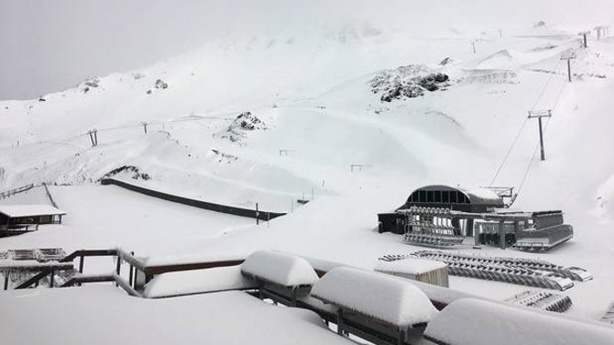
Elsewhere snow has been falling on the mountains while the West Coast has had heavy rain.
A MetService severe thunderstorm watch is in place from Hamilton to Cape Reinga that could affect the morning commute and any motorists attempting to make an early long weekend getaway.
A front had moved overhead with embedded thunderstorms, the forecaster said.
Even while most of you are asleep, we're still here watching the weather 24/7!
— MetService (@MetService) May 30, 2019
You might be in for a few bright flashes, booms and rumbles in this line of rautupu (thunderstorms) moving onto the North Island.https://t.co/prKU7O2R01
^Tui pic.twitter.com/9CZbUtqctt
"A few of these thunderstorms may be severe bringing brief heavy rain, hail and squally wind gusts," it said.
Flash flooding and destructive winds were possible.
Take extra care on the roads with thunderstorms possible this morning. Please drive to the conditions. ^TPhttps://t.co/5PaXSvPfqn
— NZTA Akld & Nthlnd (@NZTAAkl) May 30, 2019
It's left Auckland looking at a high of 18C today before the winter freeze hits, sending temperatures to 14C and 13C on Saturday and Sunday.
Monday is tipped to be the pick of the long weekend weather with a break in the rain and high of 16C.
The NZ Transport Agency is also urging motorists to be careful across the country as roads turn potentially hazardous with heavy long weekend traffic and changeable weather.
☔ Have the umbrella handy on Friday! A mostly dry Thursday in the North Island is turning wet overnight 🌧️ pic.twitter.com/8wIyXZb9z3
— NIWA Weather (@NiwaWeather) May 30, 2019
It's warning holidaying motorists heading north out of Auckland to expect heavy traffic from 1pm-6pm today. Traffic is then tipped to be heavy with returning weekenders coming south into Auckland on Monday between 10.30am-6pm.
Those long weekenders heading south out of the city should expect heavy traffic today from 10.30am through to 7.30pm.
Police national manager of road policing Superintendent Steve Greally also issued a statement telling motorists to "stay alert, be patient, and don't rush".
"More than 160 people have died on our roads this year. Tragically, many of those deaths could have been prevented if everyone took these four simple and proven road safety actions that prevent serious injury and death on our roads," he said.
Winter driving with the long Queens Birthday Weekend ahead https://t.co/gGS0g9md39
— NZTA News (@nzta_news) May 30, 2019
"Make sure everyone has their seatbelts on, remove distractions and stay focused on driving, don't get behind the wheel if you've been drinking or are tired, and drive at a safe speed for the conditions."
Long weekenders heading north can expect highs of 15C and 14C in Whangarei this Saturday and Sunday, before the rain clears on Monday for a high of 16C.
Whitianga in the Coromandel is expected to reach a high of 14C on Saturday and Sunday before a cloudy Monday with a top of 15C.
Traffic heading north and south between Wellington and the Kapiti Coast is also expected to be heavy over each day of the long weekend, NZTA said.
The capital can expect a windy and wet high of 15C today, before the temperature drops to 12C and 9C on Saturday and Sunday. Monday should be mainly fine with a high of 13C.
Saturday's when NZ reaches 'peak cold'...but wait, there's another polar blast next week too? (+4 Maps) https://t.co/49IrzLc96N via @weatherwatchnz #Kiwi #NewZealand #weather
— WeatherWatch.co.nz (@WeatherWatchNZ) May 30, 2019
In the South Island, Christchurch is tipped for a high of 14C today before the temperature plummets to a wet and wintry 8C and 9C on Sunday before the weather turns fine on Monday for a top of 12C.
Overnight temperatures will drop to a freezing 1C on Saturday and Sunday nights.
Elsewhere in the South Island, the West Coast has been hit with deluges of rain after overnight heavy rain warnings from the ranges west of Nelson to Buller and Fox Glacier.
Snowfall was expected to affect State Highway 8 at Lindis Pass with falls to about 600m yesterday along with the Crown Range Rd and Milford Rd (SH94).
The freezing weekend across the country has been likened to a weather hangover by National Institute of Water and Atmospheric Research (Niwa) meteorologist Chris Brandolini after months of warmer than average temperatures.
2019 Winter Climate Outlook for NZ! 🏔️
— NIWA Weather (@NiwaWeather) May 30, 2019
❄️ A fast and furious start, but...
📈 A colder than average season is unlikely.
☔ Rainfall near or below normal, except West Coast.
☀️ July may bring more settled weather.
🌊 El Niño influence continues, but may fade toward neutral. pic.twitter.com/oal9FuWRuQ
However, despite a second cold snap being due to hit late next week, the overall outlook for winter was for temperatures to be normal or above average, he said.
Take your Radio, Podcasts and Music with you
Get the iHeart App
Get more of the radio, music and podcasts you love with the FREE iHeart app. Scan the QR code to download now.

Download from the app stores
Stream unlimited music, thousands of radio stations and podcasts all in one app. iHeart is easy to use and all FREE


