Kiwis who have been basking in a "mardi gras" of recent warmer than average temperatures can expect this weekend's wintry blast to be like the party hangover, forecasters say.
The cold blast expected to hit in full on Saturday will send temperatures plummeting by more than 10C and dump snow on the mountains in what will be colder than usual start to June.
Auckland can expect a wet and wintry top of 14C on Saturday.
Hello Auckland! Tomorrow morning sees some rain, risk locally heavy, with possible squally thunderstorms as well. If you are out and about in the morning drive safely and to the conditions, don’t forget your brolly 🌂 and keep a check on the @MetService for updates. ^Matthew https://t.co/cxfWq6dLWM
— Auckland CDEM (@AucklandCDEM) May 30, 2019
And Police have issued a statement warning Queen's Birthday Weekend drivers to beware heavy traffic and "changeable weather conditions".
"The roads will be busy, particularly on Friday evening," says Police's National Manager of Road Policing Superintendent Steve Greally.
"If you're driving, stay alert, be patient, and don't rush."
He said Police would be active throughout the weekend, targeting high-risk driving behaviours and focusing on highways and open roads.
"More than 160 people have died on our roads this year. Tragically, many of those deaths could have been prevented if everyone took these four simple and proven road safety actions that prevent serious injury and death on our roads," says Superintendent Greally.
"Make sure everyone has their seatbelts on; remove distractions and stay focused on driving; don't get behind the wheel if you've been drinking or are tired; and drive at a safe speed for the conditions."
It has been a wet 24 hours for the west of the South Island and High Country. Here are some 24 hour rainfall totals https://t.co/Yjbq0jxdqz ^PL pic.twitter.com/NUMccK37gd
— MetService (@MetService) May 29, 2019
The winter season as a whole is expected to be milder than usual with good chances of either normal or less than normal rainfall for most regions, National Institute of Water and Atmospheric Research (Niwa) meteorologist Chris Brandolini said.
So far May was on track to be the third warmest May on record since 1909, while the autumn season was on track to be the third or fourth warmest autumn on record.
This was likely to make this weekend's cold snap feel even colder.
"We've had this kind of weather Mardi Gras and party for the past two or three months - now the weekend is going to be the hangover."
The cold chill would likely last through the weekend as a second freeze was expected to hit in the latter half of next week.
"But as we get into week two of June, things are going to likely rebound and turn milder, and we think that will likely be more indicative of the winter season," Brandolini said.
Christchurch and the east of the South Island was the region with the greatest chance of having above average temperatures.
Most of the rest of the country was likely to either have typical winter temperatures or above average temperatures.
A cold southerly starts moving up the country during Friday, and lasts through Sunday. Here's a look at minimum temperatures you can expect at a place near you this Sunday morning. You should also keep up with any severe weather prior to Sunday at https://t.co/qHyE5zhh6X. ^AB pic.twitter.com/FgrPHS2bxB
— MetService (@MetService) May 29, 2019
"So a colder than average winter for New Zealand is quite unlikely, we only give it about a 15 per cent chance," Brandolini said.
Niwa expected July to bring more warmer and settled weather than usual, although this could lead to more frosts, fogs and cold nights due to their being less clouds and moisture in the sky.
Rainfall for the winter season for the east and north of the North Island was likely to either be near normal or below normal, Brandolini said.
Near normal rainfall was also likely in Canterbury and the upper South Island.
"Put differently, a wetter than average winter looks pretty unlikely," he said.
"The other area where we think below average rainfall is a realistic possibility is the upper South Island."
"Now this is important because it's been very dry recently."
"There will be many locations across the North Island that will have a near record dry autumn."
#NewZealand: Here comes the Snow, Cold and Rain. We have the latest Maps (x5) https://t.co/PRxzlJUyG5 via @weatherwatchnz #UPDATE #weather #storm
— WeatherWatch.co.nz (@WeatherWatchNZ) May 29, 2019
If the winter continued to be dry, it could affect farmers, who irrigate their crops in spring - in areas such as the South Island and Hawke's Bay - and rely on winter rain to recharge the country's rivers and underground water reserves.
The West Coast in the South Island was the one part of the country where Niwa was expecting greater than normal rainfall.
This was partly due to the El Nino weather pattern bringing in more westerly winds from the Southern Ocean, which tend to dump rain when they run into the mountains of the West Coast.
The fact the Tasman Sea was also still warmer than average meant the skies above it were also likely to be filled with more moisture.
This process tended to "energise" cold southerly lows when they blew in and could increase "the risk for significant rainfall events", Brandolini said.
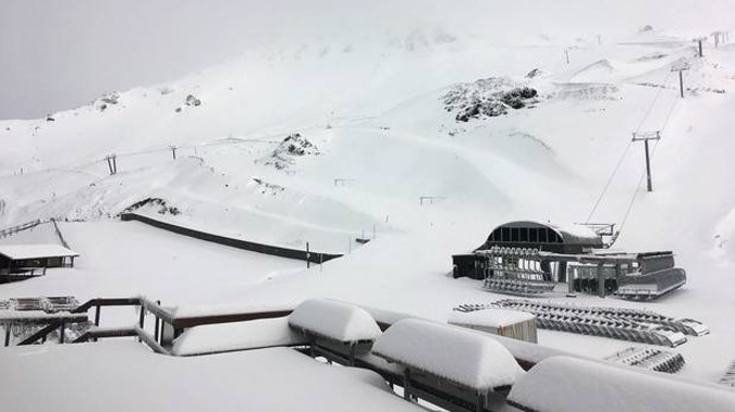
The big freeze this weekend was likely to give the ski season a good start, but Brandolini said we'd have to wait to see if the snowfall persisted.
"The ski season is real tricky. If you are a ski field, you can have a real crap year, but then if you get a big dump right before the school holidays that could save your bacon," he said.
"So it is tough one to tip how a ski field is going to be impacted."
The winter round-up comes as MetService has issued severe weather warnings for large swathes of the South Island this morning.
"The State Highway network is currently being impacted by heavy rain and strong winds, with a number of strong wind warnings across the South Island," the South Island Advisory service said.
SH73 close to Arthur's Pass, SH7 at the Hanmer Turnoff to Springs Junction, SH6 Ross to Haast, SH87 Outram to Kyeburn, and SH85 Palmerston to Kyeburn were all close due to strong winds or surface flooding.
Heavy rain warnings are in place for the West Coast, Fiordland, the headwaters of the Otago and Canterbury lakes and rivers, the ranges west of Nelson and the Buller area.
A strong wind warning was also in place for the Canterbury High Country.
Take your Radio, Podcasts and Music with you
Get the iHeart App
Get more of the radio, music and podcasts you love with the FREE iHeart app. Scan the QR code to download now.

Download from the app stores
Stream unlimited music, thousands of radio stations and podcasts all in one app. iHeart is easy to use and all FREE


