Parts of the South Island can expect a windier, wetter and wilder start to the week, with temperatures plunging by as much as 15C in the space of 24 hours.
After balmy weekend warmth that delivered highs in the mid-20s, southern New Zealand was in for a sharp change, while the north enjoyed generally settled weather.
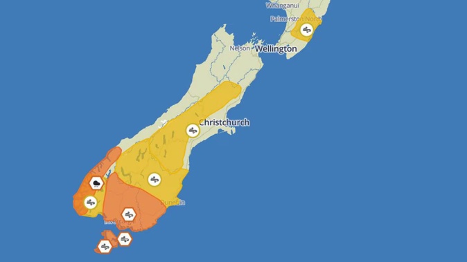
A southerly front was due to move up the South Island’s west coast on Monday, with an orange heavy rain warning in place for Fiordland on Sunday night.
MetService also issued heavy wind warnings overnight on Sunday for the Canterbury High Country, Clutha and Southland, where northwesterly gusts had potential to reach speeds of 120km/h.
“For Invercargill, the strongest winds are more likely to arrive on Monday morning, when those north-westerlies turn to a south-westerly direction, and the rain moves through,” MetService forecaster Dan Corrigan said.
Temperatures, too, were set to take a big drop.
Niwa reported locations like South Canterbury, which experienced autumnal warmth reaching into the late 20s on Sunday afternoon, could expect temperatures hovering closer to 14C on Monday afternoon.
Corrigan said clear skies over the weekend had already brought some big swings: MetService’s weather station at Dunedin Airport registered just 1C at 5am on Sunday, before reaching 24C in the afternoon.
Meanwhile, the first half of the week looked much less dramatic for the north, with mainly cloudy weather forecast on Monday and a chance of showers developing from Taranaki south in the afternoon.
“Most of the day, wherever you are in the North Island, it’s going to be fairly seasonal weather - not too windy and pretty dry – over the next couple of days,” Corrigan said.
“The change for the North Island mainly happens on Wednesday, when the front from the south moves up the country – but by the time it gets up to Auckland, it’ll be a pretty weak feature.”
The bigger feature on the horizon was a system that could move in from the Tasman Sea on Friday – possibly bringing heavy rain to the North Island.
“I know there are quite a lot of places around the country looking for more rain after quite a dry summer, so we’ll be keeping an eye on that system coming across on Friday,” Corrigan said.
Niwa forecaster Tristan Meyer said that system could a soggy end to the week for the lower North Island, particularly.
“On Friday and into Saturday, as that rain band comes through, we could get some of the heaviest rain we’ve seen in a little bit for parts of the Wellington region.”
Further afield, meteorologists had been closely watching a low near Vanuatu and New Caledonia due to potential to deepen into another tropical cyclone – but that risk was currently assessed as low by MetService.
Jamie Morton is a specialist in science and environmental reporting. He joined the Herald in 2011 and writes about everything from conservation and climate change to natural hazards and new technology.
Take your Radio, Podcasts and Music with you