In a week of torrential rain, the biggest deluge fell in West Auckland’s New Lynn, a Herald on Sunday analysis of Auckland flood data shows.
The area with the most red-stickered homes was the Albert-Eden-Puketāpapa ward area, which stretches across the isthmus from Hillsborough to Pt Chev, and back to Greenlane.
Māngere locals needed the most rescues in the flooding, while Henderson residents needed the most assistance from the fire brigade after a river in the area rose quickly, the data showed.
The Herald used data provided by Fire and Emergency NZ (Fenz) and Auckland Emergency Management, along with publicly available data from Auckland Council and MetService, to understand the extent of the storm and the resulting damage.
It showed which river rose the most and which had the highest flow rates as torrential rain belted Auckland. The data showed how much rain fell across the city and the terrifying situations Aucklanders found themselves in before Fenz was called for help.
The first reports of what would become a five-day-long unprecedented weather event in Auckland came on Friday morning, when images of submerged cars on Auckland motorways, people wading waist-deep in floodwater and collapsed buildings emerged.
As record-setting amounts of rain continued and floodwaters kept rising, people lost their homes, vehicles, treasured possessions, and even their lives.
Hundreds went without water and power while many were trapped as water lapped at their doors, toppled trees, blocked roads and lifts malfunctioned.
Emergency services in Auckland scrambled to help. At one point, every fire truck in Auckland was responding to weather-related callouts.
Between 3pm January 27 and 2.40pm February 2, 2311 flood-related calls for help were made to Fenz in Auckland.
- ‘Like thunder’: Residents escape Auckland home after large slip
- Auckland floods: what homeowners must and mustn't do - builder
- Auckland floods: What does a state of emergency mean?
- Auckland is in clean-up mode
The thousands of Fenz incident summaries provide insight into the terrifying moments Kiwis experienced across the city and the significant response required from firefighters as the torrential rain caused city-wide damage.
/cloudfront-ap-southeast-2.images.arcpublishing.com/nzme/ZREXDU5YXVEGTJYG6VSVNQTFS4.JPG)
Contractors try to clear surface flooding on Porana Road, Wairau Park, Glenfield. Photo / Brett Phibbs
Most of the calls came from Henderson and were about flooding. According to incident summary data provided to the Herald by Fenz, calls came in about people, including elderly and children, stuck in flooded houses, vehicles and lifts.
In one Henderson report, three houses were underwater, and flooding was “like a big river”; an observation subsequently supported by Auckland Council’s river level data that showed at least one river in the West Auckland suburb was running almost 6 metres above normal.
In another Henderson report, a Hilux truck was submerged in water and the driver was standing on top of it, requiring an “urgent response”.
On Friday night, calls for help often came in every minute, if not at the same time. Some incidents included rescuing groups of 43 and 55 trapped people in a single location.
/cloudfront-ap-southeast-2.images.arcpublishing.com/nzme/33XK3ZAXBZEKVCHHGJNGFQWUDY.jpg)
Hanging on the edge - landslides threaten homes on Colwill Road, Massey. Photo / Brett Phibbs
In one summary, there were four people requiring rescuing who could not swim as flooding approached the top storey of an Epsom house.
In another incident, Fenz were called to rescue an 80-year-old person alone in a flooded house.
Six adults and an elderly person needing help in Māngere required an “urgent response” just before 11pm while in the same suburb a person with dementia needed urgent evacuation.
There were reports of trees falling on houses and power lines, cars floating in floodwaters or hanging precariously, landslides, sink holes, a collapsed pool and sewage flooding into a dining area.
People with different and complex needs - including residents who use wheelchairs, are blind, had medical conditions, were sick or bedbound - called for help. A person with tetraplegia and water up to their knees in Māngere on Friday night required rescuing.
Of the 77 sites monitored and reported by Auckland Council, Hunua east recorded the most rainfall during the Auckland flood period – 639.6mm.
/cloudfront-ap-southeast-2.images.arcpublishing.com/nzme/GFT572IF45CQPGAQZG7VBSQXCY.png)
Firefighters use ropes to help rescue residents trapped by flooding in Ranui, West Auckland. Photo / Hayden Woodward
The highest levels of rain recorded in urban Auckland were in New Lynn (449.5mm), Coxs Bay (443mm), Albert Park in central Auckland (420mm), Mt Roskill (419.5mm) and Onehunga (403.5mm).
On Friday, Mayor Wayne Brown, who has been scrutinised for his response to the flooding and has since apologised, extended the State of Emergency in Auckland for another seven days as the city recovers.
Brown said “this was a downpour like none of us has ever seen before” before acknowledging that it was connected to climate change.
“Severe damage has occurred in all parts of our region. The downpour was by far the biggest in Auckland’s history. It was well beyond what even our emergency people had imagined or planned for.”
In the Albert-Eden-Puketāpapa ward area, 1.5 per cent (877) buildings were inspected. Red stickers were put on 56 buildings, meaning they cannot be used or entered as the moderate or heavy damage poses a significant risk to health or life.
Thirty-six buildings in the North Shore, 30 in Waitākere and 28 in Ōrākei were red-stickered due to the Auckland floods.
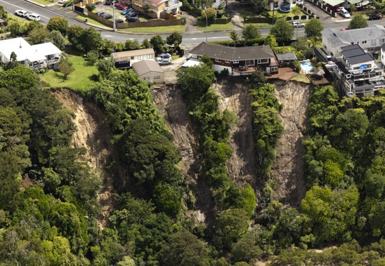
Aerial images taken by Herald photographers after the most intense dousing of rain on Friday revealed another perspective of the damage caused by the deluge.
Cliffs had been scoured away, leaving homes hanging precariously, and large parts of the city were completely underwater.
/cloudfront-ap-southeast-2.images.arcpublishing.com/nzme/7KW6MIGZVFGERK5NKPKIAG4B7I.jpg)
Public health warnings have been placed in the massive lake that has formed in the Auckland Domain. Photo / NZME
Niwa described last Friday’s rainfall as a one-in-200 year event, rounding out January to become the wettest month on record in at least 170 years.
Data from Auckland Council’s Environmental Data Portal showed the Kaipara and Hateo rivers reached the highest levels and had the biggest water flow over the past week. At the peak, the Kaipara river, which runs through Waimauku, reached 9.3m-6.6m higher than normal.
Four of Auckland’s 43 river monitoring sites appear to have been so inundated with water that they recorded nonsense measurements, including river levels of over 3km.
The Hateo River, which feeds into the Kaipara Harbour, increased 8.5m to reach 9.2m.
In Riverhead, the pressure of raging floodwaters in the Rangitopuni Stream caused a bridge to collapse. As the bridge was swiftly washed away, debris crashed into large trees, toppling them over.
The stream, one of the fastest-rising in Auckland over the past week, rose 7.3m to reach a water level of 8.1m.
Thank you to Fire and Emergency NZ, MetService, Auckland Emergency Management and Auckland Council for supplying data.
Take your Radio, Podcasts and Music with you