New Zealand is waking up to a bitterly cold day with temperatures well into the negatives and snow closing major roads.
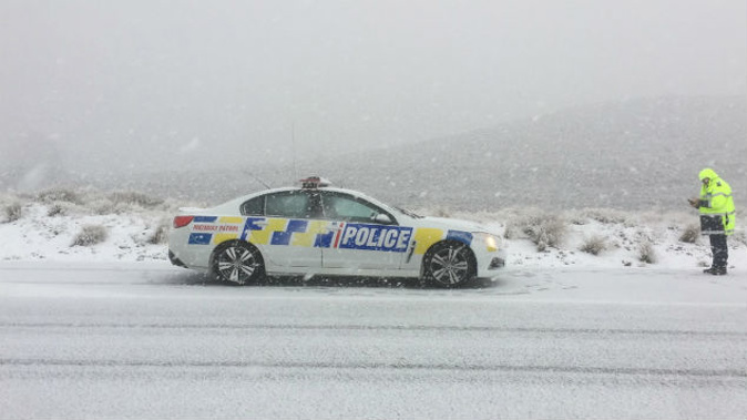
The Desert Road on State Highway 1 is closed between Waiouru and Rangipo this morning due to snow and ice after a cold front made its way up from the South Island onto the North Island overnight.
Snow was falling to 300m about Otago, Fiordland and Southland this morning, MetService meteorologist Michael Martens said.
It was still too early to know exactly where it had fallen and how much, but there were reports of snow falling in Queenstown, he said.
"We are expecting more reports to come in as people start waking up."
The coldest areas this morning were around Otago and South Canterbury with temperatures between 0 and -3C.
Ranfurly dropped to -3.1C, Pukaki -3C, Timaru -2.3C and Alexandra -1.8C.
There are road snow warnings in place for Lewis Pass (SH7), Arthur's Pass (SH73), Porters Pass (SH73), Haast Pass (SH6), Lindis Pass (SH8), Crown Range Rd and Milford Road (SH94).
Heavy snow - 20cm to 40cm - was expected above 400m in Fiordland, Westland south of Haast, Southland north of the Mavora Lakes and the western ranges of Otago south of Mount Aspiring today. Greater amounts were forecast above 600m.
In the North Island, central areas, including in valleys and the high country, were seeing temperatures around freezing level this morning.
A station in Upper Hutt recorded -0.7C, and the Desert Rd was sitting about -0.5C.
More snow was expected to have fallen in central areas, including National Park Village, which had recorded 20cm last night.
The Desert Road was subject to a snow warning with another few cm falling overnight.
Auckland hovered around 9C to 11C overnight, but would warm up to 17C through the day with showers from the afternoon.
Wellington will get to 15C with showers later today, while Christchurch will be mostly fine with northwesterlies and high of 14C.
Eastern parts of the North Island look the pick of the bunch with Gisborne and Napier mostly dry with northwesterlies and temperatures of 16C and 18C respectively.
The cold snap was not going anywhere anytime soon, Martens said.
"The cold pool that brought heavy showers in the north and snow over the Desert Rd is moving east, but another one has already moved onto the South Island.
"There will be another burst of cold air today, with showers and hail, spreading onto the North Island by this evening."
The front was forecast to move across the North Island this afternoon and evening, bringing a burst of heavy rain to western and central areas.
There was a moderate risk of thunderstorms from Horowhenua to Northland and across to eastern Bay of Plenty. These thunderstorms could produce rainfall rates of 10 to 20mm/hr, strong wind gusts of 90 km/h and small hail.
There was also a moderate risk of thunderstorms down to Kapiti, Wellington and the Marlborough Sounds at night.
In the South Island there was a moderate risk of thunderstorms about southern and western areas from coastal Southland and Fiordland to western Nelson, bringing heavy rain or snow, small hail and strong winds.
There would be a short break Friday afternoon and Saturday morning, before another system pushed through in the afternoon.
"The weekend is looking pretty unsettled and cold," Martens said.
"Most western areas will see showers as these fronts approach from the west, and then eastern areas will get showers as the ."
Southern areas at altitude will see more snow, while areas closer to sea level will be treated to sleety showers.
"We are finally back into winter," Martens said.
Coming with these winter storms were some massive ocean swells.
A burst of heavy swell was pushing up the west coast from Fiordland to Northland through today.
Another pulse late Friday and into Saturday could see swells of six metres around Piha.
"It has a long period too, 16 seconds, so the waves will be quite powerful," Martens said.
Today's weather
• Whangārei
A few showers, more frequent from afternoon. Evening thunderstorms and hail possible. Westerlies. 17C high, 12C overnight.
• Auckland
A few showers, more frequent from afternoon. Evening thunderstorms and hail possible. Westerlies. 17C high, 12C overnight.
• Hamilton
A few showers, more frequent from afternoon. Evening thunderstorms and hail possible. Westerlies. 15C high, 9C overnight.
• Tauranga
Fine until afternoon, then a few showers. Westerlies picking up morning. 16C high, 10C overnight.
• New Plymouth
Showers becoming frequent this afternoon, possibly heavy and thundery. Westerlies. 16C high, 9C overnight.
• Napier
Fine, then cloud increasing and chance evening showers. Northwest becoming strong and gusty. 18C high, 10C overnight.
• Wellington
Fine, then showers developing afternoon. Thunderstorms possible tonight. Northwesterlies rising to gale. 15C high, 9C overnight.
• Nelson
Cloudy periods, then showers from midday. Westerlies. 14C high, 3C overnight.
• Christchurch
Fine with high cloud. Strengthening northwesterlies. 14C high, 0C overnight.
• Dunedin
Showers, less frequent from afternoon, then clearing evening. Strong gusty westerlies. 11C high, 3C overnight.
Take your Radio, Podcasts and Music with you
Get the iHeart App
Get more of the radio, music and podcasts you love with the FREE iHeart app. Scan the QR code to download now.

Download from the app stores
Stream unlimited music, thousands of radio stations and podcasts all in one app. iHeart is easy to use and all FREE