Follow
the podcast on
![]()
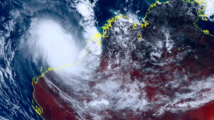
Tropical Cyclone Ilsa has made landfall in Western Australia with warnings it is the strongest storm seen in the state for almost 15 years.
It powered up to a category 5 storm, the strongest possible category, as it neared land.
Ilsa crossed land just after midnight (WA time) on Friday morning with winds speeds approaching 300kmh. It hit the Pilbara region near the Pardoo Roadhouse and De Grey, 150 km north of Port Hedland and 450km south of Broome.
The storm is now officially record breaking, the Bureau of Meteorology (BOM), has confirmed.
It set a new preliminary Australian 10-minute sustained wind speed record of 218km/h at Bedout Island, just off the WA coast. Cyclone George in 2007 hit 194km/h for 10 minutes at the same location.
“The very destructive core of Ilsa, with extreme gusts up to 295 km/h is impacting areas near Pardoo Roadhouse and De Grey during the next few hours, before tracking inland,” the BOM said.
Winds of around 150km/h could be felt inland in areas including Marble Bar and Telfer. While 90km/h winds may hit Port Hedland.
/cloudfront-ap-southeast-2.images.arcpublishing.com/nzme/WUE2GJHHOVAYVJ4TG37EFYS5EI.jpg)
Cyclone Ilsa was expected to strike Western Australia by Friday. Photo / Australian Government Bureau of Meteorology
From 150 to 300mm of rain is likely around coastal areas near Illsa’s eye during Friday.
WA’s Department of Fire and Emergency Services (DFES) issued a red alert just hours ahead of Tropical Cyclone Ilsa making landfall warning of fierce winds up which had already reached 285km/h.
Extremely destructive winds of up to 315km/h are expected around the centre of Ilsa
The red alert covers people between Bidyadanga and Port Hedland (not including Bidyadanga) and inland to Marble Bar and Nullagine.
“Stay indoors now. It is too late to leave,” said the DFES.
Those in the red alert zone need to seek shelter immediately, and hunker down until the danger has passed.
“The forecast for tomorrow is that it will maintain tropical cyclone intensity as it tracks past Telfer and further inland. Telfer could experience destructive winds up to 170 kmh,” said DFES.
The Bureau of Meteorology’s Todd Smith said Ilsa would cause a lot of damage to the landscape, and buildings that weren’t up to code.
“We know that this system is really packing a punch,” he said.
“Category five cyclones are incredibly dangerous, with wind gusts in excess of 250km/h,” he said.
“That’s going to cause a heap of damage to trees, vegetation, if there were any caravans around they would be destroyed.
“Any houses that aren’t built to code are going to suffer extensive damage from that kind of wind strength.”
- Benedict Brook & Alex Blair, news.com.au
Take your Radio, Podcasts and Music with you


