Western Australians are on high alert as Tropical Cyclone Ilsa is expected to intensify to a category 3 system within hours.
The Bureau of Meteorology forecasts the severe tropical cyclone is expected to reach landfall between Port Hedland and Broome late Thursday or early Friday.
Currently listed as a category 2 cyclone, the system is already recording winds near the centre of 100 km per hour with wind gusts to 140 km per hour.
The Bureau forecasts winds could reach nearly up to 300km/hr when it reaches the coast. It is expected to become a category 3 cyclone by Wednesday night before reaching landfall.
The Bureau states there is a “very destructive core” at the centre of the cyclone.
“Extreme gusts up to 270 km/hr is expected to cross the coast between Bidyadanga and De Grey on Thursday night, and inland to Telfer Friday morning,” the Bureau stated.
/cloudfront-ap-southeast-2.images.arcpublishing.com/nzme/WUE2GJHHOVAYVJ4TG37EFYS5EI.jpg)
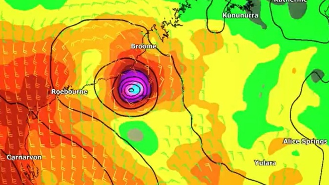
Cyclone Ilsa is expected to reach Western Australia by Thursday or Friday. Photo / Australian Government Bureau of Meteorology
Those areas that could be directly impacted include Beagle Bay to Whim Creek, including Port Hedland and Broome, and inland adjacent areas to Telfer.
Department of Fire and Emergency Services Commissioner Darren Klemm said remote Aboriginal communities, pastoral stations, mines and tourism operators in its path had been contacted.
He said DEFS has deployed 26 people to the region, including six emergency service vehicles and SES volunteers are expected to arrive into Port Hedland on Wednesday
“We’ve sent additional aircraft into Karratha, that’s two helicopters and one has been retrofitted with the capability to undertake medical evacuation should that be required,” Klemm said.
He urged people in the cyclone’s path to prepare an emergency evacuation kit, including storing “enough food and water for five days”.
Meanwhile, workers at Wallal Downs cattle station, Newcrest’s Telfer mine and caravan parks are being evacuated, along with non-critical workers at BHP’s sites across the region.
Residents in those areas should expect damage to trees, vegetation, any buildings or infrastructure that aren’t up to code, caravans and cars.
“Tropical Cyclone Ilsa is expected to intensify into a severe tropical cyclone Wednesday morning as it continues to move southwest towards the Pilbara coast,” the Bureau stated on Wednesday.
“Ilsa is forecast to track to the south and then turn to the southeast during Thursday, towards the east Pilbara coast.
“A severe impact is likely along the coast and adjacent inland parts between Port Hedland and Broome, during late Thursday or early Friday.
“During Friday, Ilsa is forecast to maintain tropical cyclone intensity as it tracks towards Telfer and further inland across the Northern Interior district.”
Heavy rainfall and thunderstorms are expected over the western Kimberley, and may extend to the eastern Pilbara from Thursday and Northern Interior from Friday. Possible high tides are also are forecast for the coast between Broome and Port Hedland during Wednesday and Thursday.
The Bureau warns in some locations the tide may be close to the highest astronomical tide of the year.
Sky News meteorologist Bradlyn Oakes said the cyclone is currently creating a heavy rain system which has struck land already
“It’s currently bringing quite heavy precipitation to coastal areas, we’re watching those rain gauges continue to tick up,” Oakes said.
“Gusting winds around the centre of this storm system, bringing the potential to storm surges and flash flooding as well as potential for thunderstorms.
“As it continues to make its way across the coastline and then into interior areas of the country, we’re likely to see it intensify to a category 4 storm, which can bring winds over 200km which can be quite damaging.”
Meanwhile, in the southeast residents can expect rain and possible severe thunderstorms across Wednesday and Thursday.
Oakes said the rain started to fall in South Australia on Tuesday night, and is expected to make its way across to Victoria and areas in New South Wales.
“There’s some potential of thunderstorms in the south east today,” she said.
“The highest risk of those (thunderstorms) being severe are in the south east corner of South Australia but there is a chance over into Victoria and New South Wales.
“Those showery conditions are really going to ramp up.”
Take your Radio, Podcasts and Music with you
Get the iHeart App
Get more of the radio, music and podcasts you love with the FREE iHeart app. Scan the QR code to download now.

Download from the app stores
Stream unlimited music, thousands of radio stations and podcasts all in one app. iHeart is easy to use and all FREE


