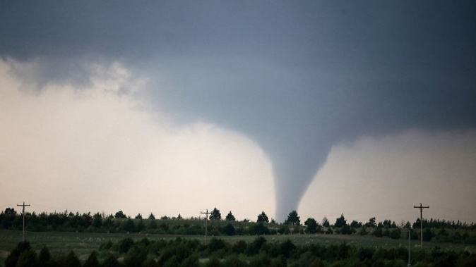
Soon after a stunning tornado touched down south of North Platte, Nebraska, storm chasers hailed it as “the tornado of the year” – a photogenic funnel that dazzled onlookers for 45 minutes but caused no structural damage.
Dozens of storm chasers surrounded the twister, capturing up-close footage of a monstrous tornado.
Even though the tornado probably had winds exceeding 289km/h, it didn’t hit much, and the worst damage was to trees and power poles.
Subsequently, the National Weather Service rated the damage as EF2 on the 0 through 5 Enhanced Fujita scale.
Over the tornado’s entire lifetime, it only travelled 4.8km. It ambled along at 6.4km/h – barely walking pace. The tornado’s maximum diameter was 45m – half the width of a football stadium. Theoretically, it could have even been possible to outrun at times.
That allowed chasers to venture extremely close to the voracious vortex, capturing unbelievable video footage of the sunlit tornado.
It formed in an environment that presented no obvious large-scale features supportive of strong or violent tornadoes. Instead, it was a sneaky “mesoscale accident”.
In meteorology, the term “mesoscale” refers to smaller, more localised phenomena.
Big, sprawling storm systems are referred to as “synoptic scale” when they span large swathes of the country at the same time, perhaps hundreds to a thousand or more kilometres.
By contrast, “mesoscale” systems are usually about 300km or less across. Some might only span a few counties.
The synoptic-scale environment featured subsidence, or broad, weak sinking motion – which reduced the number of thunderstorms that initially formed.
That’s why the lone thunderstorm that popped about 25km south of North Platte in western Nebraska was the only thunderstorm around. That isolation was key to its longevity because it didn’t have to compete with neighbouring cells for resources.
It latched on to a stalled boundary, or weak contrast between slightly different air masses.
It appears that air north of the subtle boundary had been slightly cooled by earlier thunderstorms. There was a reservoir of vorticity, or spin, along the boundary.
The storm anchored itself to the boundary and gobbled up that vorticity, stretching it vertically and spawning a tornado.
The tornado barely moved because it was constantly being fed a supply of spin.
The entire storm was ingesting the boundary – and the broader environment didn’t have much in the way of steering currents.
That allowed for a slow-moving thunderstorm with a tornado fed by rich near-surface spin.
Many of the most photogenic tornadoes form in this way.
On June 7, a tall, cone-shaped tornado spent nearly 30 minutes roaming rural farmland in the Oklahoma Panhandle near the town of Felt. It too materialised along a slow-moving boundary.
Storm chasers are either celebrating or lamenting.
Those who scored the chance to see “tornado of the year” are overjoyed, having witnessed a pageant of power and beauty unlike any other on Earth.
Those who missed it are anxiously awaiting the next one.
Take your Radio, Podcasts and Music with you