Tropical Cyclone Uesi is moving “dangerously” close to our shores.
The weather system is compounding an already dire situation caused by last weekend’s monster rainfall and a slowing moving trough that has led scores of rivers to flood and thousands of people to remain without power for close to a week.
Massive waves could attack the New South Wales and Queensland coasts over the coming days; any more rain will exacerbate swollen waterways.
The message is simple – stay away from the water, whether that’s the sea or rivers.
Uesi is currently on a collision course with Australia’s Lord Howe Island, located 600kms directly east of Port Macquarie, which it is expected to power through later today and into tomorrow.
The Bureau of Meteorology has warned the direct hit could lead to gusts up to 125km/h, huge waves and heavy rain that may lead to flash flooding. The island is home to 400 people.
The drastic conditions come as grave concerns have been raised for a Gold Coast woman who disappeared near flooded waterways in the region’s hinterland.
An alert has been issued for 26-year-old Yang Chen who was reported missing about 11am on Wednesday by a man who said he was walking near Gorge Falls in the Tallebudgera Valley when he lost sight of her.
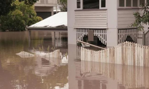
Overnight, 113mm of rain fell on Brisbane Airport, almost 150mm on the Gold Coast and a whopping 200mm on Nambour in the Sunshine Coast.
Almost 2000 customers were affected by power outages on the Sunshine Coast, utility Energex reported. Several main roads were reported to be flooded.
An “inland sea” of floodwater has appeared in the Darling Downs, to Brisbane’s east, with the Jandowae Creek flooding and large parts of the Jimbour Plain submerged, reported AAP.
The rain refuses to let up in south east Queensland with up to 60mm expected to fall on Brisbane today.
Expect downpours, albeit not as fierce, for at least the next seven days which is set to make the flooding more widespread.
“We are on the creek and can report biggest flooding I can remember,” Lee Labrie posted on social media.
“Probably the worst flooding in a long time,” Rob Norman wrote.
There are scores of flood warnings for rivers across both states including many in the Sunshine Coast, the Brisbane River and waterways from the Gold Coast to Bega.
“Recent heavy rainfall along the east coast has left catchments saturated,” said the Bureau of Meteorology in a statement.
“Most catchments have received significant rainfall during the past week and are likely to respond quickly to further heavy falls.”
CYCLONE UESI ‘DANGEROUSLY CLOSE’
None of this is going to be helped by the presence of Cyclone Uesi off the east coast of Australia.
The category 2 storm is currently heading in a south westerly direction and is due to pass directly over Australia’s Lord Howe Island tomorrow morning.
It will shortly be categorised as an “extra tropical” cyclone. But it’s not a downgrade in its strength, rather a change in its structure.
Otherwise known as mid-latitude cyclones in extra tropical storms the strongest winds, instead of being right near the centre of the system, progress further outwards.
Forecaster Accuweather has said the cyclone is now “dangerously close” to Australian shores. It’s likely to be at its nearest to NSW and southern Queensland on Friday.
Uesi’s influence, combined with the slow moving trough, could make for some miserable conditions.
“The rain just keeps on tumbling down,” said Sky News Weather channel meteorologist Tom Saunders this morning.
“We’re looking at severe storms and a flash flooding risk today. There will be a lull on Friday but by Saturday showers and storms return to NSW with the heaviest falls around the coast and ranges.”
Despite not directly hitting the NSW coast, Uesi’s effects could still be felt with heavy rain in the north of the state and brisk winds. But it’s the seas that will be the most dangerous.
“The cyclone swell will peak on Friday on the north coast of NSW where waves could average up to 5 meters,” said Mr Saunders.
“For central parts of the coast (including Sydney) the peak will be around 3 meters but that is well below what we saw last Sunday when we did have significant coastal erosion.”
Sydney could see up to 45mm of rain today in the city’s west and 20mm in the CBD. A cloudy Saturday will see a chance of showers but that threat will increase on Sunday with more downpours next week.
NSW utility provider Ausgrid has said it hopes to restore power to thousands of homes and businesses across Sydney and the Central Coast by the end of the weekend, after receiving some extra manpower from the state government to clear storm debris.
Almost 30,000 Ausgrid customers remain without power four days after the deluge in Sydney.
“With additional support to clear fallen trees we are aiming to have all customers restored by the end of the weekend. The quicker we clear vegetation the quicker we can get our customers connected,” Ausgrid said in a statement.
HEATWAVE
Up to 30mm of rain is expected in Canberra today, with a break on Thursday, before further heavy falls on the weekend. Temperatures should top out in the high twenties.
It will be dry in Melbourne today topping out at 30C. But Friday could be hot, humid and stormy with heavy rain and further showers predicted for the weekend.
Across the Bass Strait, Hobart will be drizzly with highs in the low twenties and possible showers on Friday and Saturday.
Mostly warm conditions for Adelaide with temperatures reaching 30C on Thursday. Perth will be hot and clear with a top temperature of 36C today and tomorrow but cooling over the weekend.
In the country’s north a heatwave is brewing. While Darwin can expect an afternoon storm today, for the next few days it’s likely to be bone dry with temperatures touching the mid-Thirties.
Northern Queensland is also looking parched with highs of 37C in Townsville before showers return late in the weekend.
Take your Radio, Podcasts and Music with you
Get the iHeart App
Get more of the radio, music and podcasts you love with the FREE iHeart app. Scan the QR code to download now.

Download from the app stores
Stream unlimited music, thousands of radio stations and podcasts all in one app. iHeart is easy to use and all FREE


