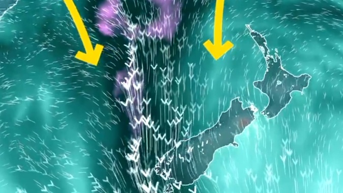
An inbound “atmospheric river” may deliver parts of the South Island’s West Coast one to two times their monthly rainfall in the space of a few days - raising risks of flooding and slips.
MetService has issued a raft of new weather alerts for the South Island, including an “orange” heavy rain warning for much of Westland for Tuesday to Thursday.
Over that period in the region, as much as 600mm to 800mm could accumulate about the ranges - with peak hourly rates of 20mm to 30mm - along with 200mm to 300mm about the coast.
The extreme downpours - also flagged by local Civil Defence groups on social media this morning - may cause streams and rivers to rise rapidly, with surface flooding and slips possible, MetService said in a statement.
“This is a significant heavy rain event with the potential for upgrade to a red warning.”
An orange warning was also in place for Fiordland, north of George Sound, where about 150mm to 250mm of rain could fall on Tuesday, with peak rates reaching 20mm/h to 30mm/h.
Elsewhere, MetService has issued a strong wind watch for Fiordland - where north-to-northwest winds could hit gale strength overnight Monday and Tuesday - and also for the Canterbury High Country, for 24 hours from noon Tuesday.
Heavy rain watches were in place for southern Fiordland, the headwaters of the Canterbury lakes, and in the Grey District and Westland north of Hokitika.
Niwa said the wild weather was the result of low pressure combining with an “atmospheric river” - long, snaking features that are well known to ferry huge volumes of subtropical moisture into regions like the West Coast.
Later in the week, the rain and wind was expected to spread north as the front moved up the country and a series of smaller lows developed.
Wellington and southern Wairarapa could see strong winds by Wednesday.
On Friday, it was possibly rain could reach warning amounts in central areas of the North Island, from Taranaki to Bay of Plenty.
Niwa meteorologist Ben Noll earlier told the Herald the event could prove critical for delivering much-needed rain to the South Island’s hydro lakes ahead of winter - but also for alleviating dryness in places like drought-hit Marlborough.
“The risk, however, is that some of the dry, cracked ground in these regions simply won’t be able to take the level of rain that’s coming - and then you get surface flooding,” Noll said.
“So, we’re potentially looking at one of New Zealand’s busiest weather weeks since the start of the year: it’s been a while since we’ve had a high-impact event like this covering so many regions.”
This story was originally published on the Herald, here
Take your Radio, Podcasts and Music with you
Get the iHeart App
Get more of the radio, music and podcasts you love with the FREE iHeart app. Scan the QR code to download now.

Download from the app stores
Stream unlimited music, thousands of radio stations and podcasts all in one app. iHeart is easy to use and all FREE


