KEY POINTS
- Mayor: "This is a 100-year event, there is a huge amount of rain"
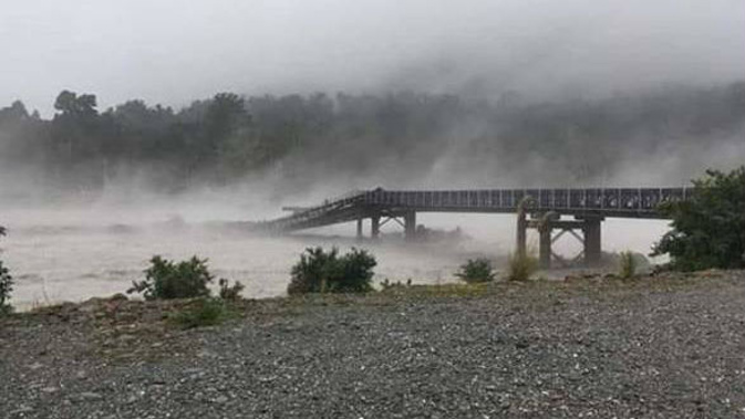
- Waiho Bridge washed out, other roads closed and impassable
- Storm edging north up South Island on Wednesday morning
- Remnants of Cyclone Trevor set to bring more wet weather to NZ next week
A wild storm that has washed out a South Island bridge, closed major roads and schools and forced evacuations is moving further north this morning - while the remnants of a major cyclone may bring more widespread rain for New Zealand.
The West Coast is this morning continuing to be hammered by the autumn storm: A state of emergency remains in place in Westland while Buller is next in line for a battering. Flooding is widespread, with Franz Josef and Haast getting a hammering.
The Waiho Bridge at Franz Josef is washed out - the dramatic moment was caught on camera. The only way south now is by helicopter.
/arc-anglerfish-syd-prod-nzme.s3.amazonaws.com/public/RX4V7L27GVF2DD4CTIHAL4NK6E.jpg)
"I've never really seen the power of the water like it has been today ... this is another level," said UK tourist Oliver Harcus.
He and his partner were stuck in a Franz Josef campground overnight due to flooding.
The flooding hasn't only been restricted to rivers, surface flooding has also resulted in road and school closures throughout the region.
"The roads that we came in on, they're pretty treacherous all the way down," said Harcus.
"There were definitely roads that would not be driveable now, they were just driveable when we passed."
And there appears there will be little respite from the weather, with a cyclone in the Tasman due to bring a new "rainmaker" to parts of New Zealand next week.
"Next week the remnants of Cyclone Trevor team up with another front to bring maybe the best chance yet at rain into northern New Zealand - one to watch," WeatherWatch forecaster Philip Duncan says.
Bad weather is still to come with severe rain warnings in place for Buller from Tuesday night until midday today.
/arc-anglerfish-syd-prod-nzme.s3.amazonaws.com/public/UTMQPTEW4JBYBG2MFM7BWQIQW4.jpg)
Westland District Mayor Bruce Smith said the rain had dropped from about 3am this morning. He expected the state of emergency to be lifted "today or tomorrow".
"The big focus now is working out the immediate things to tend to. The Waiho Bridge is our lifeline, for the 1.1 million tourists we get annually."
The NZ Transport Agency had told him it could be fixed in 14 days, but he had other advice it could be restored in 10.
"I'd be very disappointed if it was not up and running in 14 days."
There were 450 tourists kept in Franz Josef overnight, and they would be allowed to travel north later today.
"We could have released them last night back to Hokitika but there was a risk factor," Smith said.
With the Waiho Bridge out of action the only way south now was "by helicopter".
"It is really unusual to get a 100-year event, right across Westland. Normally it is concentrated in one place, but this was right across, so it has been a really big event," the mayor said.
"The Haast River was at the highest level it has ever been. We had 800mm of rain, I can't remember there ever being that much in my life."
Smith said they were lucky the rivers held their banks.
"In the Haast River it was lapping at the rock walls, flowing over, if there had been any structural problems there could have been some major issues. Additional protection at Franz Josef held too."
Heavy rain heading for North Island
MetService meteorologist Micky Malivuk said this morning the centre of the system had moved north of Hokitika to Greymouth, and the heaviest rain this morning was forecast about north Westland and Buller.
The heavy rain should clear in the South Island by midday, before making its way on to the lower and central North Island.
Hokitika and Franz Josef were the hardest hit over the past 24 hours, both receiving 160mm, Malivuk said.
Westland Mayor Bruce Smith told Newstalk ZB last night heavy rain was at the base of their problems but people remain the focus of the council and Civil Defence.
"This is a 100-year event, there is a huge amount of rain … I haven't seen all of the rivers impacted in Westland at exactly the same time," he said.
Farmers on the south side of the Waiho River have already started to evacuate but the rising river was causing further headaches, Smith said.
West Coast Emergency Management Group said in a media update on Wednesday morning that more than a dozen roads remained closed.
These included the Waiho Bridge which had been completely destroyed, State Highway 73 due to a slip about Candy's Creek, and SH6 between Hokitika and Makarora.
Smaller sections closed included the road south of Haast to Jacksons Bay, South Turnbull Rd in Okuru, south end Arawhata Bridge for 200m, Hokitika Gorge carpark, road to Kokatahi, Sunset Point, and Hans Bay (Lake Kaniere) to Kokatahi via Dorothy Falls.
There were reported power outages in Awatuna, Kaihinu and Kokatahi.
The state of emergency was declared for the Westland District at 5.45pm yesterday.
Earlier, MetService meteorologist Melissa Oosterwijk said Westland and Buller are expected to be the hardest hit.
The heavy rain causing chaos on the West Coast is expected to ease as the front heads up the rest of the country. There are severe rain warnings in place for the ranges near Marlborough, but it is unlikely to hit the urban areas, Oosterwijk said.
Weather Watch say this rain is likely to fall apart as it moves into the North Island on today and tomorrow.
"It's unlikely to deliver enough rain to help seriously reverse the big dry - although some rain will be very welcome," WeatherWatch says.
"But this secondary burst of rain connected with Trevor early next week may perhaps bring better chances of North Island rain."
Schools and roads throughout the West Coast were forced to close on Tuesday and there were a number of evacuations throughout the West Coast.
/arc-anglerfish-syd-prod-nzme.s3.amazonaws.com/public/BZHR7DATGRHIPOJQTBWRO6JJ2I.jpg)
The severe flooding has taken out the bridge over the Waiho River.
"I called a state of emergency, the reason for that is that we've lost the Waiho Bridge at Franz Josef, it's been demolished," Westland mayor Bruce Smith said.
"We've got serious problems in Haast where the water on the Haast River is lapping the stop-banks.
"We've got an issue with the Fox Glacier Bridge where the abutment of the bridge has been washed in underneath, we're unsure what is going to happen there."
/arc-anglerfish-syd-prod-nzme.s3.amazonaws.com/public/W5X4GCV4LNBUJLGJ2ZB6PKULJY.jpg)
Farmers on the south side of the Waiho River were self evacuating yesterday but the rising river was causing further headaches, Smith said.
The Hokitika River was expected to peak on Wednesday morning around 4 o'clock, with the flooding throughout the region described as a "100-year event".
Franz Josef and Haast had felt the worst of the rain with rainfall of 250mm and 160mm respectively in the last 36 hours, according to MetService. Hokitika recorded a rainfall of 50mm.
In comparison Christchurch's yearly rainfall was 600mm, while Auckland's was 1200mm.
By the time the front reached Hamilton and Auckland on Thursday morning it would only brings showers, Oosterwijk said. There were isolated showers in those two cities forecast for today too.
Today's weather
Cloud increasing, chance shower from this morning. Northerlies. 25C high, 17C overnight.
Cloud increasing, chance shower from this morning. Northerlies. 25C high, 18C overnight.
Cloud increasing, chance shower, more likely at night. Northerlies. 26C high, 16C overnight.
Cloud increasing. A few showers. Northerlies. 24C high, 18C overnight.
New Plymouth Cloudy with a few showers, turning to rain late afternoon. Strong northerlies, changing lighter southwest evening. 22C high, 13C overnight.
Napier Cloud increasing, with a few showers at night. Gusty northwesterlies, easing at night. 28C high, 17C overnight.
Whanganui Cloud increasing, with rain from evening. Gusty northwesterlies, dying out at night. 24C high, 13C overnight.
Wellington A few showers, turning to rain afternoon, briefly heavy, clearing evening. Gale northerlies, easing late afternoon, changing southerly overnight. 20C high, 14C overnight.
Nelson Rain, easing early afternoon then becoming fine. Northwest, strong at first, turning southwest at night. 21C high, 13C overnight.
Christchurch Occasional morning rain, then fine spells. Northerlies easing morning, afternoon southerly change. 23C high, 12C overnight.
Dunedin Fine spells. Chance shower, mainly around the middle of the day. Southwesterlies developing around midday, briefly strong. 19C high, 9C overnight.
Take your Radio, Podcasts and Music with you
Get the iHeart App
Get more of the radio, music and podcasts you love with the FREE iHeart app. Scan the QR code to download now.

Download from the app stores
Stream unlimited music, thousands of radio stations and podcasts all in one app. iHeart is easy to use and all FREE


