Civil Defence is urging Aucklanders to keep up with the latest forecasts after a heavy rain watch was issued for the city.
MetService issued the watch for eastern parts of Auckland north of the Harbour Bridge, Great Barrier Island and Coromandel Peninsula.
The watch is in place until 6pm tonight.
This comes as MetService is concerned that heavy rain set to lash Northland today could cause more slips and falls in the region after the amount of rainfall in recent months.
An orange heavy rain warning has been issued for areas north and east between Kaitaia and Mangawhai and up to 70mm of rain is expected to fall.
The warning is in place to 4pm today.
"The amount of rain isn't as high as we would usually issue a warning but you can imagine after the amount of rainfall we've seen there since July to August the grounds are really wet," said MetService metrologist John Law.
There are also concerns that streams and rivers could rise rapidly.
Auckland and Coromandel residents are being also being told to watch out for the deluge.
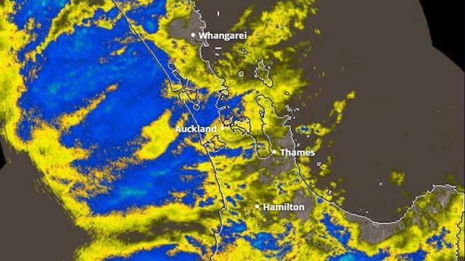
A MetService radar shows that majority of the country is covered by cloud this morning.
- 'A tough time': Farmers forced to dump milk as floods block roads
- Evacuations in Nelson after river breaches banks; weather warnings upgraded for Auckland
Meanwhile, a cold blast is set to bring snow to state highways and alpine passes throughout the country today, with MetService forecasting snow showers for both the North and South Islands.
The heaviest snowfalls are set to affect North Island roads. Between 6cm and 10cm of snow is forecast for the Napier-Taupo Rd (State Highway 5) and the Desert Road (SH1), from 5pm on Monday until 3am on Tuesday.
A heavy snow watch is in place for Gisborne, Hawke's Bay and Taupo, from Matawai to the Kaimanawa and Kaweka Forest Park, for six hours from 8pm Monday.
Law said snowfall in the North Island was due to a combination of moisture from the north and cold air from the south.
Those eastern ranges could see up to 800mm of snowfall.
"Worth keeping that in mind if you're heading out tonight, there could be snow around those ranges," said Law.
In the South Island, residents are in for a wintry day with showers and low-level snowfall.
Law said some of that snow may even be seen as low as sea level.
Waka Kotahi NZ Transport Agency is urging drivers across the country to watch for snow. As well as the North Island roads, warnings are in place for Porters Pass, Lewis Pass and State Highway 1 between Dunedin and Waitata.
In Canterbury, snow showers are set to affect highways until Tuesday afternoon.
Lewis Pass (SH7): Snow is expected on the road from about 4pm on Monday until 6am on Tuesday. Expect 2-3cm of snow to accumulate on the road.
Porters Pass (SH73): Rain is expected to turn to snow on Monday afternoon. Expect 2-4cm of snow to accumulate between 4pm on Monday and 4pm on Tuesday.
Further south, snow showers are also forecast for Dunedin's Northern Motorway (SH1, Dunedin to Waitati) until 6pm on Monday.
The showers will lower to about 100m on Monday. Expect 1-2cm of snow to accumulate at times.
Dunedin motorists have been warned roads will be treacherous today, following a spate of incidents caused by blustery weather which tied up emergency services in the South yesterday.
A MetService spokesman said a cold wintry blast was spreading up the South Island and the next few days would feel like a return to winter, even though it was technically spring.
"I'm hoping people haven't put their winter woollies away yet," the spokesman said.
Roofs ripped from homes in Southland
Wind warnings in Otago and Southland have lifted, but residents are still dealing with the aftermath of severe gales on Sunday.
Power has been restored to most of Southland after widespread outages. Nearly 30 areas across the two regions have had power cuts throughout the day.
Severe wind across the region caused damage to powerlines, and crews have been working to repair the issues since the afternoon.
Only a few suburbs in Invercargill remain without power, which should be fixed this morning.
The strongest wind on Sunday - 127km/h - was recorded inland at Clarks Junction.
Bluff had the worst of the damage, with several roofs ripped off houses.
A number of shipping containers also toppled over at the port.
MetService said the far south bore the brunt of the showers and wind, with gusts of 115km/h recorded at Invercargill.
Trees were down across the region.
Two flights out of Invercargill were cancelled on Sunday and extra care was needed on State Highway 87 between Mosgiel and Kyeburn and SH1 from Waitaki Bridge to Clinton.
The Cardrona and Treble Cone ski fields were closed due to gale-force winds.
- Additional reporting ODT/RNZ
Take your Radio, Podcasts and Music with you