Researchers have untangled one of New Zealand’s most complex fault zones, in a groundbreaking study with potential global implications for earthquake science.
Their just-published findings reconstruct thousands of years of activity in the Marlborough Fault System, which stretches across much of the northern South Island.
It linked New Zealand’s two behemoth, big-risk plate boundary systems – the Alpine Fault and the Hikurangi Subduction Zone – while endlessly absorbing local pressure from “strike-slip” motion, where rocks at the boundary slipped past each other.
Over millions of years, rocks within the system were being transferred from the Pacific plate to the Australian plate, as the boundary itself gradually shifted to the southeast.
Running parallel within it lay four major faults – Wairau, Awatere, Clarence and Hope – which have been active for tens of millions of years.
While they’ve been involved in big events in the past – including a 7.5 event in 1848 that caused widespread damage – intriguingly, none were among the incredible 25 set off by 2016′s massive Kaikoura Earthquake.
Just why, remained one of the biggest questions still facing scientists – yet the new findings, published in the journal Earth and Planetary Science Letters, have taken them much closer to understanding how the system works.
Study author and GNS Science geologist Dr Russ Van Dissen said he and colleagues, from the University of Southern California and University of Sheffield, wanted to know whether the plate motion was always being accommodated in the same way across the system – or if it was being shouldered by individual faults within it, at different times.
/cloudfront-ap-southeast-2.images.arcpublishing.com/nzme/IBCQGCBXARFHRDNYC7E73IJSOU.png)
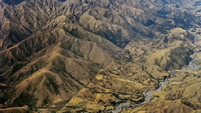
The Marlborough Fault System - linking the Alpine Fault and Hikurangi Subduction Zone - stretches across much of the northern South Island. Image / Wikimedia Commons
The answer lay within tell-tale signs of displacement in exposed river terrace surfaces.
Contrary to long-held assumptions, they discovered it had maintained a steady boundary slip rate over the last 12,000 to 14,000 years – allowing the entire system to “keep up” with hundreds of metres of plate movement.
More interestingly, they found the faults essentially worked together to take up this motion, with some slipping faster than others at different periods.
“It’s like a trade-off: we might see one fault speeding up and another slowing down, but the rate of motion across the system stays the same,” Van Dissen said.
The findings raised the need to consider fault systems as a whole – and could ultimately help change what scientists understand about similar ones overseas, in areas like Southern California.
“Of this type of study, I think this is the first and the best – and it’ll stay the best for a while.”
Beyond mere geological curiosity, the findings had implications for estimating the region’s earthquake risk.
“By knowing there’s more individual variability between these faults, it can help us forecast the seismic hazard of the area more realistically.”
Meanwhile, another new study has shed fresh light on deep-seated heat within the central part of the vast, sunken continent beneath us: Te Riu a Māui/Zealandia.
Drawing on decades of data and observations, GNS scientists mapped the depth at which temperatures below and around New Zealand reached what’s called the “Curie point” - where it became so hot that certain minerals lost their permanent magnetic properties.
As expected, the team found that depth to vary, depending on different geological environments.
“Volcanic areas tend to have a shallower depth for this temperature, because of the presence of shallow magma, whereas beneath mountainous places like the Southern Alps, it’s a lot deeper because the crust is thicker,” study leader Dr Craig Miller said.
He said the results take scientists closer to understanding the magnetic minerology beneath New Zealand, while also offering data for potential new offshore areas of geothermal resource to explore.
Jamie Morton is a specialist in science and environmental reporting. He joined the Herald in 2011 and writes about everything from conservation and climate change to natural hazards and new technology.
Take your Radio, Podcasts and Music with you
Get the iHeart App
Get more of the radio, music and podcasts you love with the FREE iHeart app. Scan the QR code to download now.

Download from the app stores
Stream unlimited music, thousands of radio stations and podcasts all in one app. iHeart is easy to use and all FREE


