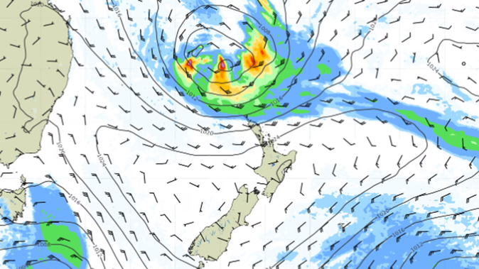
The remnants of Tropical Cyclone Lola will merge with another storm system and pummel New Zealand late this weekend when a massive rainmaker will drench the north of the country.
Strong winds, heavy rain and huge swells are forecast to ravage areas from Northland to East Cape on Sunday and Monday before a week of rain plagues the top of the north.
On Friday and Saturday, meanwhile, freezing temperatures will be felt around the country, with conditions more akin to winter as a cold blast from the Southern Ocean brings snow and frost.
While MetService forecast an 18C high for Auckland for a cloudy and showery Friday and Saturday, it issued heavy snow watches and snowfall warnings further south, with Christchurch tipped to see a 0C low.
It comes as strong wind and heavy rain warnings in place throughout Thursday begin to lapse, after a day where gales cancelled flights in Wellington, blew a truck on to its side in Canterbury and thousands of lightning strikes lit up the country’s skies.
MetService meteorologist John Law said the last throes of Tropical Cyclone Lola, which smashed Vanuatu over Tuesday night and into Wednesday, would merge with another area of low-pressure off Australia and run toward New Zealand.
“It’s looking like we’ll see watches and warnings issued, particularly in those northern areas,” Law said.
“It’s worth keeping an eye on the forecast as we head through the weekend,” with severe gales and heavy rain for Northland, Auckland, Coromandel, Bay of Plenty, Waikato, Gisborne, and Hawke’s Bay from Sunday evening through Monday, he said.
Ocean swells about the Bay of Plenty, Northland and elsewhere could bring wave heights of up to 6m on Monday.
Private forecaster WeatherWatch said what was left of Lola would create a “squash zone” of gale northeasterlies which could threaten power cuts and bring down trees.
“Due to the nature of the large high-pressure zone to the south along with the low to the north, there will likely be a fine line between rain and dry weather - which means forecasts and risk areas may still change a bit in the coming days,” WeatherWatch said.
Lola fell apart 48 hours after it first exploded to life, the forecaster said.
Friday, meanwhile, will see temperatures plummet while thunderstorms, snow and hail could strike Dunedin in the morning.
It is a marked change from warmth which has graced the country over the past few days, with Napier hitting the highest temperature in the country on Thursday at 24.1C.
A heavy snow watch for Fiordland, Southland, Clutha, Dunedin, Central Otago and Queenstown Lakes should lapse by 11am on Friday at the latest, with snowfall expected above 300m.
Road snowfall warnings are in place for the Lewis Pass State Highway 7, Arthur’s Pass SH73, Haast Pass SH6, Lindis Pass SH8, the Crown Range Rd, Milford Rd SH94 and the Dunedin to Waitati Highway SH1. Up to 15cm of snow could settle in places above 800m.
The last road snowfall warning should lapse by 2pm on Friday.
Raphael Franks is an Auckland-based reporter who covers breaking news. He joined the Herald as a Te Rito cadet in 2022.
Take your Radio, Podcasts and Music with you