Forecasters expect to see dramatic weather in the top half of the North Island early this week, as already strong winds cause waves to crash on parts of Tamaki Drive this morning.
A strong wind watch is in force from this evening to Monday afternoon, with high tide around 10.18pm tonight and 10.34am tomorrow morning for the eastern bays.
Metservice has issued a heavy rain watch for Gisborne with a focus on the area north of Tolaga Bay.
"There may be the possibility of thunderstorms as part of the weather system bringing the rain in.
"Rainfall amount may approach warning criteria. Another period of heavy rain is possible on Tuesday, and an associated watch or warning may be issued closer to the time.
"I wouldn't be outdoors unless you really had to. Plan ahead when driving to and from work, drive safely."
The heavy rain watch is valid from 12pm tomorrow to 12am on Tuesday.
Severe thunderstorm watches are also in place for Northland and Auckland in addition to heavy rain warnings, while severe gales are possible in Auckland.
The rain could create surface flooding and slips, and strong winds could snap tree limbs and whip up rough seas along the east coast, according to forecasters.
The current weather system looks to dominate until the end of the working week, MetService's severe weather update says.
"A slow-moving low-pressure system is forecast to lie to the west of New Zealand this week, directing a strong and moist north-to-northeast flow across the country.
"A front embedded in this flow is expected to move eastwards across northern and central New Zealand today and Monday, delivering a period of heavy rain, possible thunderstorms, and strong northeasterly winds to many places.
"Heavy rain warnings and watches are in force for parts of northern and central New Zealand. In addition, a strong wind watch is in force for Auckland. People are advised to keep up to date with the latest forecasts in case any changes are made, or further areas are added."
A severe thunderstorm watch for Northland lasts from 1pm today to 3am on Monday.
Severe thunderstorms could see localised downpours of 25-40mm/h, and patches of torrential rain of more than 40mm/h.
There could also be a tornado risk.
"While possible tornadoes may cause some structural damage, including damage to trees and power lines, and make driving hazardous," MetService said.
"If any tornadoes occur, they will only affect very localised areas."
MetService say a slow-moving low-pressure system over the Tasman Sea is expected to direct a very moist northeast flow over the country during much of the outlook period, bringing rain to northern and central New Zealand.
"For northwest Tasman and for Mount Taranaki, there is moderate confidence that rainfall amounts could still meet warning criteria on Tuesday.
"For parts of Coromandel Peninsula, Bay of Plenty and northern Gisborne, there is high confidence that rainfall amounts will meet warning criteria on Tuesday and Wednesday.
"Finally, for a large area from Waikato across the central high country to Hawkes Bay, and northwards to the remainder of Gisborne, there is Low confidence of significant heavy rain from Tuesday to Thursday."
Heavy rain warnings, strong winds could hit gale strength later this evening
The heaviest rain in Auckland and Great Barrier Island is due from 10pm tonight, particularly north of the Harbour Bridge.
A heavy rain warning is in place from 10pm until 2pm Monday with 80-110mm of rain possible over that time. The city is also under a severe gale watch for the same time period.
The Coastguard was called to several water-related incidents in the early hours of this morning.
An emergency call was made by a yacht near Okahu Bay in the Waitematā Harbour at 4.53am after they were unable to anchor their vessel because of strong north-easterly winds and a damaged rudder.
Pilot Vessel Wakatere and volunteers from Coastguard Auckland came to the yacht's assistance and towed it to Wynyard Quarter.
A yacht also called for assistance at 3.28am after strong winds pulled it from its anchorage in McKenzie Bay and it ended up grounding on Calliope Bank.
Quick actions by the skipper meant the vessel was able to self-rescue, a Coastguard spokesman said.
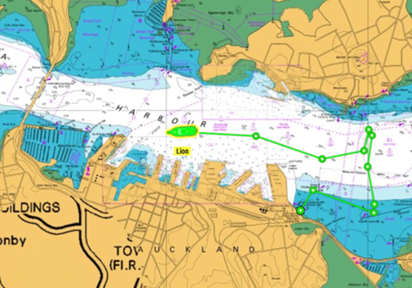
A yacht was unable to anchor near Okahu Bay this morning due to strong winds and a damaged rudder. Image / Supplied
The Coromandel Peninsula and Bay of Plenty west of Ōpōtiki are also under heavy rain warnings for Monday, while Kaikoura, Waikato, Waitomo, parts of Gisborne, Taumarunui, Taupō, parts of Taranaki and Tasman west of Motueka are under heavy rain watches.
Niwa is also warning eastern coastal areas will be buffeted by strong northeasterlies today and tomorrow, with the potential for tree limbs to come down and rough seas to be whipped up.
The rainmaker will also affect the northwestern edge of the South Island, particularly Buller. But the east coast and lower part of the South Island are expected to remain dry, MetService forecasts.
Weatherwatch said the forecast for early next week was for "unstable" weather, with downpours likely and a chance of thunderstorms.
"This is the result of very moist warm air at the surface and cold upper air," the forecaster said.
"The exact placement of these storms at this stage is a little hard to define but anywhere about the upper and western North Island looks to be in with a chance, especially as frontal zones and troughs move through.
"Monday and Tuesday still look to have reasonably strong wind dynamics so a small tornado is also a possibility."
Take your Radio, Podcasts and Music with you