Several low-lying areas of New Zealand could potentially see the first snowfall of the year next weekend as the "first proper winter blast of 2022" lands on our shores, one weather service is predicting.
"In recent days Tasmania, Victoria and NSW have all had snow events on the mountains and ranges with snow levels as low as 300m," WeatherWatch.co.nz noted today.
"NZ has the chance of snow to sea level in Southland and Otago and to low levels in some parts of Canterbury, based on data today."
That means potential snowfall on Saturday in Dunedin, Invercargill, Gore and Queenstown.
But the long-range forecast came with the caveat that a lot could change between now and then, said Philip Duncan, head forecaster for the privately-owned weather service.
WeatherWatch is basing the forecast, in part, on a Southern Ocean storm that is looking possible this week. It could usher in an Antarctic southerly by Friday or Saturday.
"It's too early to lock this in but the data and reliable models are certainly aligning more to bring a wintry outbreak to the country at the end of this week," Duncan said, adding that there should be a clearer picture of what's in store by Tuesday.
New Zealand's national weather authority, MetService, has taken a more conservative approach to the possible wintry blast.
"Next weekend's quite far ahead to be making decisive statements about snowfall forecasts," MetService meteorologist Dan Corrigan told the Herald. "It's just too far out."
MetService has, however, forecasted a front that is expected to bring heavy rain to the West Coast on Tuesday before cutting a path over the North Island on Wednesday.
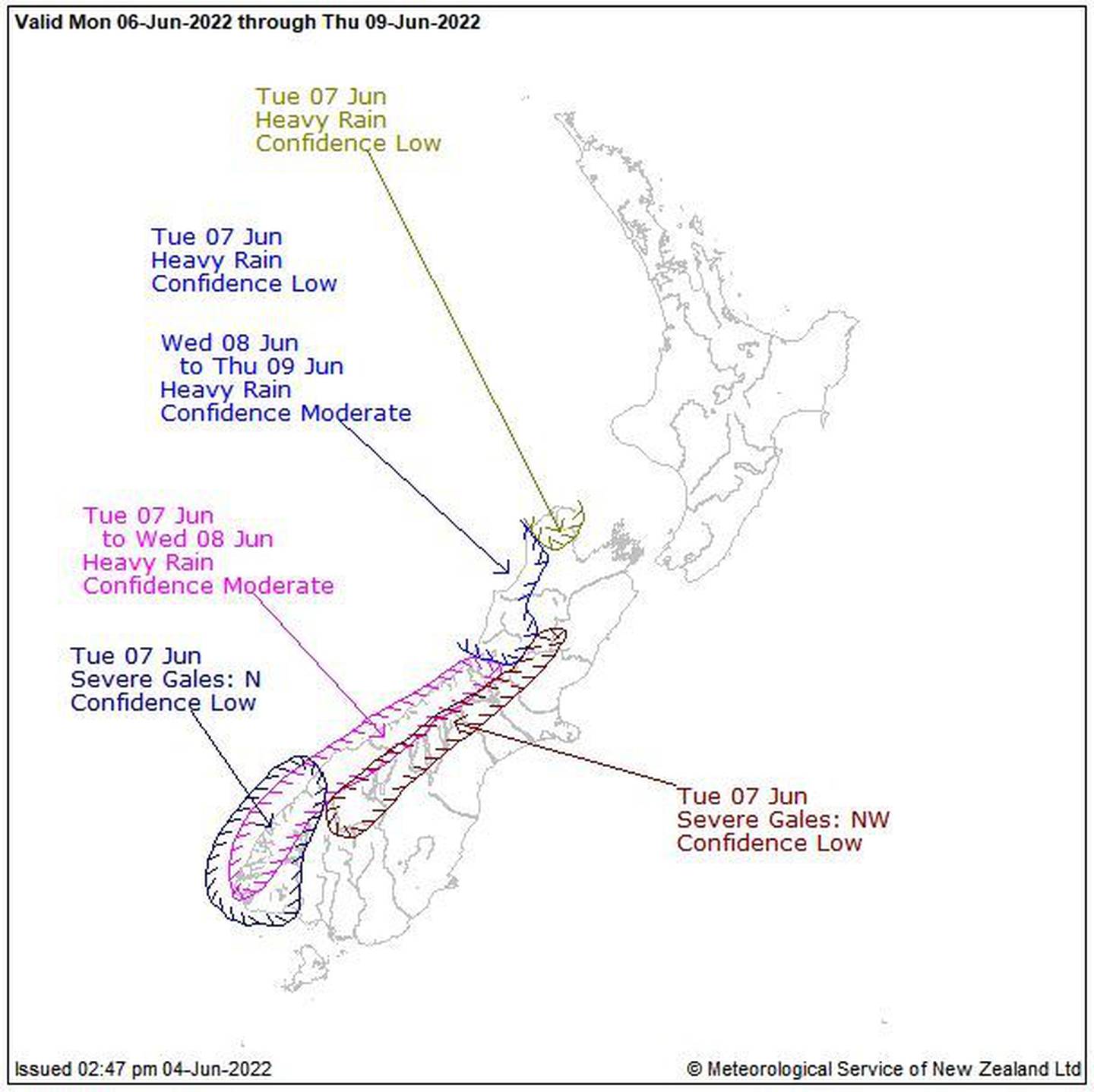
MetService says a trough should move onto New Zealand from the Tasman Sea on Wednesday. Photo / Supplied
"A trough should move onto New Zealand from the Tasman Sea later Wednesday and cross-country early Thursday, followed by another weak cold front late Thursday," MetService said in its daily severe weather outlook. "These fronts and trough are preceded by strong and moist northerlies and followed by unsettled northwesterlies."
The past few weeks have seen milder-than-usual weather, according to WeatherWatch.
"June sees a return closer to normality – however still not entirely normal," the private weather service noted in its long-term ClimateWatch update this past week. "June will lean warmer than average again by 0.5 to 1C nationwide – a trend that has been going for years now.
"But rainfall returns closer to normal in June and across winter. The first half of June looks to be wettest with perhaps more high pressure around the Tasman and northern NZ mid to late month."
La Nina, meanwhile, is still active but is so weak as to not impact New Zealand much and is expected to continue to fade over the winter, WeatherWatch noted. It may return by spring, but that would result in a "quite rare" triple-dip of the weather phenomenon.
- by Craig Kapitan, NZ Herald
Take your Radio, Podcasts and Music with you