A slip on a major highway through the Karangahake Gorge is likely to keep State Highway 2 closed for the rest of the day as more rain is on the way this afternoon.
Torrential rain has lashed Northland, Auckland, Bay of Plenty and Coromandel - and the intense rainfall is set to boomerang back tomorrow after dumping on the eastern North Island tonight.
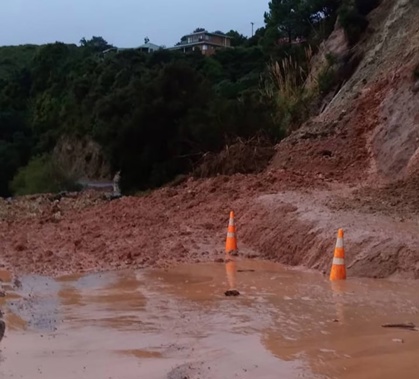
Motorists on SH2 were being told to delay their journey or go another way after reports of a slip in the Karangahake Gorge. In an update on the Waka Kotahi journey planner website, it advised caution in the area with the slip first reported about 12.55pm.
Both lanes of SH2 Karangahake Gorge were expected to be blocked for the rest of the day between Albert St and Bush St after a slip came down.
/cloudfront-ap-southeast-2.images.arcpublishing.com/nzme/AS452NHW75FHPG4C4NJEULRTKU.jpg)
A slip in the Karangahake Gorge is closing State Highway 2. Photo / Paeroa Towing Services
Police were called to the large slip around 12.45pm and clean-up crews are on their way, a spokesman said.
Police were turning motorists around, and contractors were trying to clear the slip. Motorists were told they’d have to use the Thames Coast Rd SH25 or SH29.
Tuesday is set to see a reprieve in the weather in Auckland, the last chance to hang any washing out to dry before heavy rain sets in for the rest of the week, MetService said.
It comes as fresh slips, fallen trees and washouts have blocked roads around the Coromandel, including State Highway 25, where downpours have been heaviest.
278mm of rain has been recorded in the Coromandel Ranges since 12am Sunday, MetService meteorologist Dan Corrigan told the Herald.
Up to another 70mm could fall in Coromandel later today, Corrigan said, as the storm tracked east.
An orange heavy rain warning remains in place in Coromandel until 6pm this evening; another remains until 2am tomorrow for Bay of Plenty west of Kawerau, including Rotorua.
A heavy rain watch was issued for Bay of Plenty from Kawerau to Te Kaha where rainfall amounts might reach warning criteria.
Bay of Plenty east of Te Kaha and Gisborne north of Tokomaru Bay has an orange heavy rain warning until 8pm Tuesday.
While the highest rainfalls remained in the ranges, it still posed a risk to people in coastal areas as streams and rivers swelled downstream, Corrigan said.
He said there were “flow-on effects” of high rainfall in the ranges, including the possibility of further slips.
In Bay of Plenty, west of Kawerau, through to Gisborne, up to 100mm of rain could fall by the end of today, he said.
/cloudfront-ap-southeast-2.images.arcpublishing.com/nzme/W2UOEFKYORG5DOKWVYALBKF3H4.jpg)
Slip blocking Te Kouma Rd in the Coromandel this morning. Photo / Ann Leef
With a slip on SH25, just north of the Raumahanga boat ramp on the Thames coast, Waka Kotahi NZTA was asking motorists to drive with caution and expect delays.
“Carey Rd, Port Charles is closed due to a void that has formed in the road over a culvert approximately 900m from the start of the road. The estimated reopening is late this afternoon,” Waka Kotahi said.
“Te Kouma Road is closed following a slip that has come down blocking the road just past Puriri Rd. The estimated reopening is midday today,” the agency said.
Thames Coromandel District Council said travellers should add extra time to their journey and prepare for delays.
“Our roading crews are clearing debris and fallen trees as quickly as possible.
“We are odds-on for a significant weather event this week so the key messages are stay connected and well informed, and above all don’t take risks,” Thames Coromandel Civil Defence controller Garry Towler said.
‘Sheets’ of torrential rain makes for dangerous commute
The heavy rain and strong winds caused commuter chaos for Aucklanders this morning as the sub-tropical storm moved across the North Island, bringing downpours and strong winds.
Motorists heading into the city centre from West Auckland faced a challenging journey with reports of surface flooding and congested traffic on the motorway.
A woman driving from New Lynn described high winds also adding to the mayhem - as strong gusts drove the sometimes heavy rain horizontal.
“On top of what’s on the road, the wind is driving sheets of torrential rain, reducing visibility. That’s the worst part.”
Lashings of rain started to fall from about 4am to 6am, MetService said, with about 10mm of rain recorded at Auckland Airport between 5am and 6am.
As much as 60mm of rain has fallen on Auckland since Sunday morning, with 63mm recorded at a Helensville weather station and 49mm at Mt Roskill.
As the weather cleared this morning, with few isolated showers expected about the city this afternoon and tomorrow, temperatures were set to remain relatively high.
Corrigan said Aucklanders were in for hot, sticky evenings with temperatures in the high teens.
“You might need to get rid of a blanket or two, just as we’re heading into May,” he said.
Corrigan said the moist air, brought in by a warm low-pressure system from the Tasman Sea, was being stopped from moving along.
“There’s a stubborn area of high pressure out over the Pacific Ocean, over the Chatham Islands, and that’s preventing our weather systems from moving on as they normally do,” he said.
“That’s why we’re getting this steady feed of rain and humidity from the north this week that’s just kind of moving back and forth across the upper North Island.”
Take your Radio, Podcasts and Music with you