Forecasters say the season’s third tropical cyclone could form within days, amid basin-wide ocean warmth across the Pacific.
MetService meteorologist Stephen Glassey said multiple models are hinting at a system developing near the Solomon Islands around the middle of next week, with the current risk considered to be moderate.
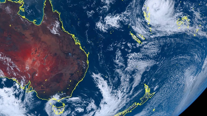
That came with the potential for a weak low pressure system, now positioned just northeast of Fiji, to drift westward into an area considered “favourable” for cyclone formation, with higher sea surface temperatures and light upper-level winds.
The season has already brought two severe tropical cyclones: Mal, which reached category 3 strength in mid-November, and last month’s Lola, which briefly became a category 5 system before its remnants caused widespread flooding and power cuts across the upper North Island.
“There’s no indication that we’ll get a tropical cyclone coming toward New Zealand at this stage, but we are flagging a moderate risk of a tropical cyclone, somewhere around that area, from around the middle of next week,” Glassey said.
Niwa meteorologist Ben Noll said it remained to be seen what influence a system, if it did form, could have for New Zealand - and while wet weather was likely across the North Island in early December, that wasn’t linked to possible cyclone activity.
Meanwhile, he said a globe-circling pulse of rain and thunderstorms called the Madden-Julian Oscillation (MJO) could again prove a cyclone-building factor as it passed through the region.
“Pretty much every time we’ve had the MJO come across the western Pacific from October through November, it’s resulted in tropical cyclone formation – so you’d say the conversion rate is pretty good,” Noll said.
“And indeed, we’re expecting more MJO activity in the west Pacific in early December: so you can start to see that increased risk for a system forming during the first week to 10 days of the month.
“As for exactly where or when, it’s still a bit tenuous – but it definitely looks like the environmental conditions are going to become favourable for activity up there.”
Noll said there was currently an “abundance” of warm water spread across the ocean, with El Niño conditions driving up sea surface temperatures in the east and a vast blob called the West Pacific Warm Pool staying in place above New Zealand.
That could fuel more cyclone activity this season - and Niwa has already forecast an elevated risk across large areas of the West Pacific.
For New Zealand, however, that risk was lower, with a subtropical ridge of high pressure above the country likely to prevent big rainmakers from travelling here with the relentless frequency of last summer.
“However, given that the first two cyclones of the season swung near us, it’s impossible to say exactly what the third one will do,” Noll said, “and you wouldn’t take any option off the table at this point.”
Jamie Morton is a specialist in science and environmental reporting. He joined the Herald in 2011 and writes about everything from conservation and climate change to natural hazards and new technology.
Take your Radio, Podcasts and Music with you