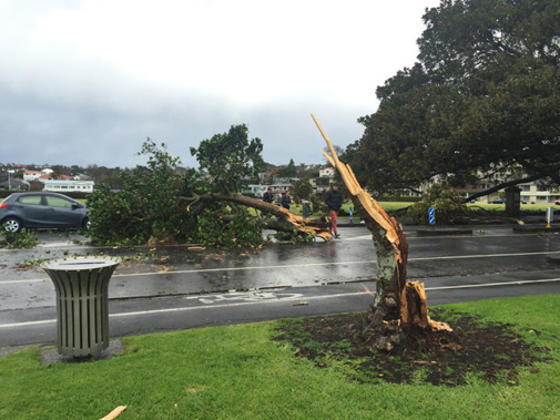
UPDATED 6.34PM: More than 200 homes are still without power tonight after this morning's weather bomb in Auckland.
More high winds and thunderstorms are also forecast for the Bay of Plenty, Northland and Auckland.
Heavy rain's also expected which may cause flash flooding, and there are weather warnings for Wellington and Wairarapa - with snow down to 300 metres forecast.
This afternoon strong wind gusts and mini tornadoes have caused damage in Bay of Plenty.
A mini tornado ripped the roof off a garage in Mount Maunganui.
A couple of buildings in Tauranga city have minor damage, while at Papamoa Beach some houses have been damaged in strong winds.
Police and the Fire Service have received a large number of calls.
Earlier today in Auckland, three people were rescued from a home in Penrose after a 25m tree trapped them in their bedrooms.
It is understood a tornado, described as small and weak, hit Pt Chevalier before blowing across the North Western Motorway about 10.45am
A Manurewa resident said a mini tornado hit their front yard about 11.10.
Snow is now falling near Gore, as the wintry change hits the South Island.
Weather Watch says cold air will move in tonight in the south and then all over the country tomorrow.
Warnings in place
A severe thunderstorm watch is in place for Bay of Plenty.
MetService said a squall line with a brief period of very strong winds, heavy rain and possible severe thunderstorms is forecast to cross eastern Bay of Plenty by 4 this afternoon.
It said wind gusts of over 110 kilometres an hour and a small tornado are possible during this time, mainly near the coast.
MetService warns winds of this strength can cause structural damage, including to trees and powerlines, and may make driving hazardous.
Take your Radio, Podcasts and Music with you