Snow is starting fall as a chilly autumnal blast sweeps up the country bringing freezing temperatures and gales to central and southern New Zealand.
Parts of Otago are now under a light coating of snow with flurries expected this morning and heavy snow falling in higher alpine regions.
MetService meteorologist Mmathapelo Makgabutlane told the Herald the cold front is moving across the South Island from Monday and into Wednesday.
“That’s both day-time temperatures, as well as overnight temperatures. We also see it in terms of possible snowfall, we’re expecting snowfalls at least in the mountainous areas but also in the lower and sort of eastern parts of the South Island we could see the snow level going down to about 400 to 700 metres, which is the first snowfall of the year reaching those levels.”
As well as this, Makgabutlane said there will be a “sharp southerly change” and strong winds along the eastern coastline.
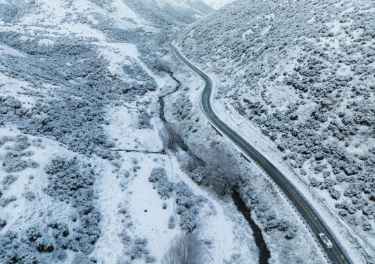
This morning the Crown Range Rd outside Queenstown is covered in a light dusting of snow with the resort township sitting on 6C.
A heavy snow watch is in place for the Queenstown Lakes and Central Otago from Queenstown to Alexandra.
Snow flurries are expected down to 600m with heavy snow falling above 800m.
“Not quite reaching lake level in Queenstown, but for areas that are a little bit more elevated than that we could see snow reaching those areas,” said Makgabutlane.
In Southland, places like Gore and Invercargill could be recording day-time highs of 11 or 12 degrees on Tuesday, she said.
A strong wind watch is in force for the top of the South Island, including coastal Marlborough and the Sounds, Banks Peninsula and Wellington.
Overnight, she told the Herald, some areas could drop below freezing, with forecasts for Alexandra showing a low of -1 degree on Tuesday night.
Wednesday is another cold day for the south, and Canterbury is in store for a high of 12 degrees.
The North Island isn’t immune from the chilly weather, and Makgabutlane said from about midday on Tuesday Wellington could see that southerly change come through.
“Wellington does have a watch for strong winds, and that is from tomorrow [Tuesday] afternoon 1pm and for Wednesday early morning.”
This wind will be ushering in cooler temperatures, which the bulk of the North Island will see on Wednesday.
“We only have a maximum of about 12 degrees for Wellington city, elsewhere we see maximums in the region of about 15.
“We also see those overnight temperatures Wednesday night to Thursday for the North Island starting to drop down to those lower single digits and even below freezing. We see places like Taumarunui overnight Wednesday to Thursday morning at a minimum of one degree that will very likely be the coldest minimum of the year so far.”
Take your Radio, Podcasts and Music with you