Just in time for the Christmas countdown, an incoming subtropical airmass is set to deliver some uncomfortable sticky days – and potentially heavy rain.
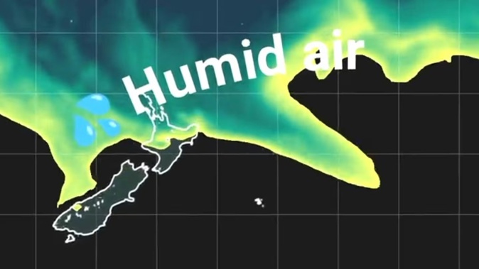
Niwa meteorologist Ben Noll said several waves of humid air were expected over the upper North Island next week, as a low pressure system now developing over the Tasman Sea dragged down moisture from the subtropics.
“If we look to Sunday and the course of next week, humidity levels could be at summer-standard at times – so if you’re stepping outside, you’ll notice it.”
We really began feeling clammy when the air was warm enough to make us sweat - but carried enough water vapour to interfere with that process.
Noll pointed to some of the forecast “dew point” values – the temperature at which, if cooled, water vapour from air would condense onto a surface, and which provided a better indicator of the mugginess we feel than relative humidity.
“When we’re looking at a place like Auckland next week, the dew point will be uniformly above 15C, and at times as high as 18C or 19C,” he said.
“It depends on the person, but once you get to a dew point of around 16C or 17C, that’s where things become a little more uncomfortable.
“And we’re looking at a good three-to-five-day stretch where things are going to feel a little sticky out there.”
With that mugginess came the potential for heavy downpours – particularly along the ranges of Westland from Saturday afternoon through Sunday, MetService reported.
A band of rain wrapped across the North Island bringing heavy bursts of rain and strengthening northwest winds, especially around the southern tip of the North Island.
Conditions were meanwhile expected to be drier around the south of the South Island, while air pushing in from the south could spell a cooler start to the week for eastern areas south of Marlborough Sounds.
For the north, more muggy days could follow over the coming weeks, Noll said.
“As we go through the rest of the month, it does look like we’ll get more opportunities for this humid weather – although it’s early December when we really see this tropical connection.”
While these subtropical patterns were more reminiscent of La Niña climate cycles, Noll said it highlighted the fact that, even amid El Niño, the western Pacific above New Zealand continued to run warm.
“At times during summer, there’ll be times we get these flows from the north – maybe relatively infrequently – and then other times, we’ll be getting drier, less humid air masses from Australia,” he said.
“I certainly wouldn’t be expecting as many of those humid, subtropical days that we experienced last summer – but at some levels, what we see next week will be repeated through the season.”
Niwa is due to release its climate outlook for the December-to-February period tomorrow.
Jamie Morton is a specialist in science and environmental reporting. He joined the Herald in 2011 and writes about everything from conservation and climate change to natural hazards and new technology.
Take your Radio, Podcasts and Music with you