New coastal flood maps predicting how climate change will affect Hawke’s Bay’s coastline in the next 75 years have been released.
About 2000 properties in the Napier City Council area alone have been placed in flood zones as part of the new maps.
The mapping will affect building and resource consents for new developments, and even renovations, for those living within inundation zones.
However, the Napier council says, “this is not triggering a conversation about managed retreat for us”.
The mapping shows areas at risk of being “affected to different degrees” by coastal flooding up until 2100 between Tangoio and Clifton - if no further flood mitigation is done.
Those areas include parts of Tangoio, Bay View, Westshore, Pandora, Napier, Awatoto, Clive, Haumoana and Te Awanga, among others.
“This does impact individual properties,” said Napier Deputy Mayor Annette Brosnan.
“This is really important for our planning. The key areas that the information will be used is in our regulatory departments.
“So inside our building and resource consent teams, when we are considering things like floor levels inside the affected inundation areas up until that 2100 [date].
“Any time someone makes an application for a building consent inside these zones, our team will be looking at what this modelling says for their property and making determinations as part of those consents around things like floor levels.”
However, Brosnan said, “this is not triggering a conversation about managed retreat for us” for any properties around Napier.
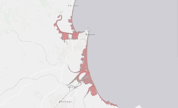
/cloudfront-ap-southeast-2.images.arcpublishing.com/nzme/EAGU3HPLNFC4HFYSG6ZHC5PGAQ.JPG)
A new flood map around Napier shows the impact of coastal flooding, with a 1 per cent annual exceedance probability (a one-in-100-year coastal flood). Photo / NCC
Insurers will be able to use the data, and it will also be used for helping “mitigation measures” with the region’s infrastructure.
Brosnan said exactly what those mitigation measures could be, would be addressed by the committees working on those projects. It is unclear if it will include seawalls.
She said the modelling showed impacted areas could be “affected to different degrees” by coastal flooding by 2100.
The new coastal inundation maps have been prepared as part of a report, Clifton to Tangoio Coastal Inundation, commissioned jointly by the Napier City Council, the Hastings District Council and the Hawke’s Bay Regional Council.
All three councils received the new mapping on Thursday, the same day affected property owners were notified.
“This work shows scenarios up to 75 years into the future, so we can help our community be prepared,” said Napier Mayor Kirsten Wise.
/cloudfront-ap-southeast-2.images.arcpublishing.com/nzme/JR6TSKDZUJECJPCDSHRGLHMQPI.jpg)
A map of flood-prone areas around Napier. Photo / NCC
The new mapping was developed by environmental and engineering consultants at Tonkin & Taylor Ltd and peer-reviewed by the National Institute of Water and Atmospheric Research (Niwa).
It includes predications for a one-in-100-year coastal flood event (1 per cent annual exceedance probability) and a one-in-50-year flood event (2 per cent annual exceedance probability).
The new maps are available through an online portal at gis.hbrc.govt.nz/Hazards/.
A helpful way to search on the portal is to click on the Coastal Hazard tab, then click the Layers arrow (on right side), then tick Coastal Inundation box, then select 2023 model for either 2 per cent or 1 per cent annual exceedance probability.
Council will host two information sessions for anyone with questions at Chapman Pavilion at McLean Park on Monday (3.30pm to 6.30pm), and also on Tuesday at East Pier Hotel (3.30pm to 6.30pm).
Gary Hamilton-Irvine is a Hawke’s Bay-based reporter who covers a range of news topics including business, councils, breaking news and cyclone recovery. He formerly worked at News Corp Australia.
Take your Radio, Podcasts and Music with you
Get the iHeart App
Get more of the radio, music and podcasts you love with the FREE iHeart app. Scan the QR code to download now.

Download from the app stores
Stream unlimited music, thousands of radio stations and podcasts all in one app. iHeart is easy to use and all FREE


