Wild weather is continuing in parts of the country - as strong wind warnings are issued and heavy snow blankets the South Island.
Flights to Queenstown and Invercargill have now been cancelled due to heavy snow.
Air New Zealand has cancelled its flights from Auckland to both places before Queenstown Airport tweeted at 10:45am: "Runway clearing is currently in progress and flights have been cancelled until further notice. The snow is expected all day and is continuing to fall heavily."
Yesterday, an Air New Zealand flight from Invercargill to Auckland was struck by lightning shortly after take-off.
✈️❄️#SNOW update 10:45am: runway clearing is currently in progress and flights have been cancelled until further notice. The snow is expected all day and is continuing to fall heavily. For further flight information please visit our website: https://t.co/ptn9h0QJqQ pic.twitter.com/rPQwjJGczh
— Queenstown Airport (@NZQN) September 27, 2020
Newshub reported Flight NZ 696 was struck. Newshub's travel editor Dan Lake was onboard.
"There was a bright flash of white and a rumbling sound, and the screens and lights flickered a bit. It was just like when you have a power surge at home, but other than that, it wasn't very dramatic at all," he said.
/cloudfront-ap-southeast-2.images.arcpublishing.com/nzme/LZCDZGZSO5AP5FVMLGW66BB2JE.jpg)
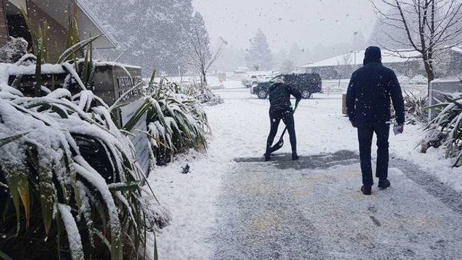
Snow falling in Wanaka this morning. Snow is expected to sea level in parts of the South Island today and tomorrow. (Photo / Supplied)
Air NZ added in a statement: "Lightning strikes are not uncommon - aircraft are designed with this in mind and our pilots train for this scenario."
Snow is expected down to sea level in parts of the South Island today and tomorrow.
Heavy snow warnings are in place for Fiordland and parts of Southland, and snow is forecast for Dunedin, Clutha and Central Otago, Nelson west of Motueka, Buller and Westland north of Arthur's Pass.
MetService is forecasting strong wind in Canterbury, Marlborough, the lower North Island and parts of Hawke's Bay.
Waka Kotahi NZTA senior journey manager Neil Walker said the Lewis Pass (SH7) was likely to stay closed until mid-morning.
All the passes were expected to have snow and the only question was how heavy, he said, while the motorway heading north from Dunedin was likely to be affected in the cold snap.
We've had a some snow to sea level already in the far south, but the cold front West of Fiordland is heading north, followed by a more southerly flow pushing coldest air and snow showers much further inland. https://t.co/NQBonCMXTZ ^RK pic.twitter.com/dq6zG4l2Xr
— MetService (@MetService) September 27, 2020
The message for anyone travelling in the South Island was to be vigilant and check weather and road conditions before they set out.
"Conditions can change at short notice so be really vigilant ... if you can avoid travel that's what we'd be recommending."
/cloudfront-ap-southeast-2.images.arcpublishing.com/nzme/XKJHEZ7SJNDKJP22VT7I2L6KXE.png)
Snowy Queenstown. (Photo / James Allan)
Aucklanders can expect showers, mainly this morning. Strong westerly winds are also on the cards for the City of Sails and a temperature high of 14.1C is forecast.
An overnight low of 11C is expected.
Walker said the concern for the Auckland Harbour Bridge was wind speed, with the strongest gust overnight at 70km/h.
Some lanes on the bridge would be closed if wind gusts reached 80km/h, and at 90km/h they would look at closing the bridge, he said.
"Because we've got that temporary fix on there, if anything does occur on the day we're going to probably take a more cautious approach on closing the bridge."
🎿 If you've planned to hit the sloped for the school holidays next week you' re in luck 🏂⛷️
— NIWA Weather (@NiwaWeather) September 27, 2020
🌬️ A series of strong cold fronts will make their way onto New Zealand on Monday-Tuesday. Check the forecast and for road closures before you travel. pic.twitter.com/vVG3sBuVya
A strut on the bridge was repaired last week after a truck, hit by a strong wind gust, crashed into it.
The agency advises avoiding the bridge if possible, travelling during off-peak hours, using the western ring route or taking public transport.
Auckland Transport will look to replace double-decker buses with single-decker buses for services over the bridge today as a safety precaution, but Walker said there were plenty of seats on other bus services.
'Pretty nasty weather'
Niwa's Nava Fedaeff said the South Island was in for very strong winds throughout the day, and widespread snowfall above 200m tomorrow.
"When you've got those cold temperatures and the wind combined, the wind chill is going to feel like -20 in some places - so very bitterly cold in some places."
Snow could get as low as sea level in places like Invercargill and Dunedin.
Showers blowing onto the South Island from the west. That changes this morning as the flow turns more southerly & the coldest air blows onto NZ, pushing snow showers further inland over Southland,Clutha & southern Otago. Warnings & Watches in place: https://t.co/NQBonCMXTZ. ^RK pic.twitter.com/0eKU2K9GD7
— MetService (@MetService) September 27, 2020
The strong winds coming into the west coast of the country are caused by a rapidly deepening low pressure system, common in the Southern Ocean but not often reaching as far as New Zealand, she said.
Northwesterly winds in the North Island bring a turbulent day for Auckland with gusts from 70-90km/h.
But the strongest winds, with gusts in excess of 100km/h, will be along the west coasts, around Christchurch, and in Wellington in the afternoon.
Road snowfall warnings
Motorists are being warned to stay up-to-date before hitting the road in many parts of the country; as snow showers affect some well used highways.
Desert Road (State Highway 1) is among those affected from 7am to midday today when 1cm to 2cm of snow may briefly settle about the summit, the MetService said. More snow is expected later this evening.
/cloudfront-ap-southeast-2.images.arcpublishing.com/nzme/B7HLMDDFHBELRM3ZFPHULRNGVA.png)
It's a winter wonderland in Queenstown today. (Photo / James Allan)
Lewis Pass (SH7) is set to be affected up until the early hours of tomorrow morning, about 4am, when between 15cm to 2cm of snow may accumulate above 500m.
Other roads on the warnings list are Arthur's Pass, Haast Pass, Lindis Pass, the Crown Range Road, Milford Road and the Dunedin to Waitati Highway.
There are no warnings in force for the Napier-Taupō, Remutaka Hill Road and Porters Pass road.
An update from MetService on the road snowfall warnings is expected at 11am today.
Take your Radio, Podcasts and Music with you