An El Niño climate pattern expected to spell a hot, dry summer for New Zealand’s north-east is looking to peak unusually late – meaning its mix of influences could linger on through next autumn.
Niwa meteorologist Ben Noll says the big climate driver might not reach its full strength until late January, in the thick of summer - while a “weather wildcard” could still leave the door partially open to tropical rainmakers finding their way down here over the warm season.
In New Zealand, El Niño tended to bring drier conditions in the north and east, wetter ones in the south and west - and westerlies prevailing generally everywhere.
Broadly, that’s still what’s on the cards for the country over the next few months, with a switch from south-west to westerly and north-westerly winds later this month predicted to expose New Zealand to more warm air masses from Australia.
Farmers in particularly exposed regions like Hawke’s Bay and Gisborne have long been preparing for the prospect of parched soils as warm westerlies begin to blow-dry away soil moisture.
The potential intensity of this El Niño - the first we’ve experienced in nearly a decade - has already led some meteorologists to draw comparisons with drought-making major events in our past, like 1997-98 and 1982-83.
But unlike in past El Niño summer events, Noll said, we’re seeing the cycle play out in a very different background climate state – meaning its signals aren’t proving quite as clear-cut as before.
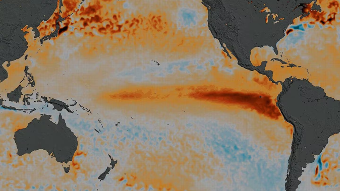
That owed to what Noll called a weather wildcard: a vast swathe of warm water - piled up by three years of La Niña and the ocean-heating effects of background climate change – in the equatorial West Pacific, where another tropical cyclone could form up next week.
Normally, El Niño developed as warmer water amassed in the eastern Pacific, while water in the western Pacific cooled below average.
This tilting of the seesaw then influenced what’s called the Walker Circulation, acting as a focal point for cloud, rainfall, and thunderstorms, and ultimately shaping climate and weather patterns right across the planet.
- Here comes the heat: NZ to get early dose of El Niño summer later this month
- Spring storm: Record heat for east, rain, wind alerts for south, then snow
- Here come the windy westerlies: how El Niño is adding to spring’s bluster
- El Niño incoming: NZ's climate to take 'rapid turn' within weeks
Meteorologists have already observed the set-up of this pattern: notably with a “westerly wind burst” late last month that helped to push the warmest water from the west to central and eastern regions of the Pacific.
Another westerly wind burst was forecast to occur within the next few weeks, which could leave El Niño with a longer tail in 2024.
“It means it’s going to peak later than sooner – perhaps the back half of January,” Noll said.
“At this point, I think it’s safe to say we’re going to bake in El Niño-like patterns right through the first part of 2024, maybe right up to the doorstep of winter.”
Yet, such was the amount of persistent warmth lingering in the western Pacific – where sea temperatures were remarkably still running a degree above normal – the balance hadn’t yet been shifted eastward.
“So, even though we’ve had this discharge of heat further to the east, sea temperatures are actually warmest toward the west – and this is the factor that is causing us headaches in understanding what this El Niño summer is going to look like.”
As it’s proven over the last three years – and through what was the north’s wettest summer in history – the giant patch of warm water above New Zealand provided a potent source of moisture for storm systems making their way down here.
Even amid a strengthening El Niño, we’ve seen subtropical moisture delivered to New Zealand in recent deluges, like that which brought us the watery remnants of tropical cyclone Lola last week.
Thanks to the way in which El Niño has configured atmospheric pressure in our region, Noll said a high ridge to New Zealand’s north should help block subtropical systems from reaching us.
But that might not always prove the case this summer.
“Even though high pressure may hug the North Island for long stretches of time, if this weakens for even two or three days, there’s an outlet there for a system to drop down here,” he said.
“And that all comes back to the fact we have an atmospheric signal that is distinct from past El Niño events.
“We’re getting that El Niño-like flavour maybe 70 or 80 per cent of the time - and that other 20 to 30 per cent is what’s different here.”
Jamie Morton is a specialist in science and environmental reporting. He joined the Herald in 2011 and writes about everything from conservation and climate change to natural hazards and new technology.
Take your Radio, Podcasts and Music with you