Despite most of summer now behind us, New Zealand’s most dangerous fire conditions are just beginning. Why? Science reporter Jamie Morton explains.
Follow our Port Hills fire live updates here.
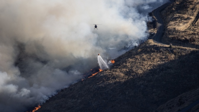
What’s the background picture to the Port Hills fire?
Whatever sparked the Port Hills’ latest big blaze yesterday, background conditions couldn’t have been much more risky.
Fire danger in the area was assessed at “Very High” to “Extreme” at the time the fire broke out, with low humidity, temperatures reaching into the high 20s and flames fanned by warm, gusty, north-to-northwest winds.
Fire and Emergency New Zealand’s (Fenz) most recent seasonal outlook had already singled out parts of Canterbury as a hot spot to watch for fire danger – pointing particularly to those stronger, west to northwest winds.
“These often align to produce days with high temperatures and low humidity that escalate fire dangers significantly, especially in eastern areas, contributing to easier ignition and rapid fire spread.”
Climate scientist Dr Nathanael Melia said the “drought code” in the area registered a value of near 400 yesterday – well above the threshold for extreme fire danger – while relative humidity had fallen to around 20 per cent.
/cloudfront-ap-southeast-2.images.arcpublishing.com/nzme/HQUN56EKQBDXVMPU5EWR3SWO3Q.JPG) A local state of emergency has been declared after a fire broke out in the Port Hills. Photo / RNZ, Charlotte Cook
A local state of emergency has been declared after a fire broke out in the Port Hills. Photo / RNZ, Charlotte Cook
Added to that was “extremely dry” and gusty winds which drove extreme fire spread rates, he said.
“These conditions resulted in immense difficulty in containing the fire as it spread fast up the steep Port Hills and was often able to leapfrog ahead, starting new fires in a phenomenon known as ‘spotting’.”
- Dwelling destroyed in Port Hills fire; blaze still not contained
- "We will get through this": Christchurch Mayor gives update on Port Hills blaze
- Port Hills blaze is nearly seven years to the day after the last
- How did the Port Hills fire start?
This extreme fire behaviour made fighting at the main fire front far too dangerous, he said, as ground crews could become rapidly surrounded.
At this point, it wasn’t clear what, or who, started it.
“Recent wildfire ignition sources include a camping stove, malfunctioning powerlines, and a metal landscaping blade sparking off rock,” Melia said.
“I renew my call to ban certain activities that may lead to ignition during extreme wildfire conditions, and I encourage relevant parties to investigate plans and legislation along these lines.”
What is New Zealand’s fire danger for the rest of the season?
Niwa’s latest seasonal outlook predicted a shift to more westerly winds between February and April, meaning regions yet to experience drier conditions “should remain prepared for that possibility as this change occurs”.
Fenz’s outlook said the likelihood of El Nino conditions continuing through summer and into autumn could also mean an extended fire season.
“In some areas, the worst fire danger conditions may not occur until late February, March or even April.”
Many parts of New Zealand are already in prohibited or restricted fire seasons.
Fireworks are currently banned in Ahipara township and surrounds, Karikari Peninsula, Ripiro Beach, Mackenzie Basin, Central Otago, Naseby, Upper Waitaki, Lake Ōhau, Otago Lakes and Glendhu Bluffs, Canterbury, Kaikōura, Wellington District, Kāpiti and Wairarapa.
This week, Auckland, Northland and Bay of Plenty also moved to restricted seasons.
Bay of Plenty district manager Jeff Maunder said there’d been very little rainfall across most of the Bay of Plenty in the past two weeks which has dried out grass and vegetation significantly and increased the fire risk.
“There is also little rain forecast for the next few weeks, so vegetation and grass will continue to dry out, further increasing the fire danger,” he said.
“This means vegetation fires will start more easily, spread more rapidly and be more difficult to control.”
“We have the largest block of commercial forestry in New Zealand (over half a million hectares) in the Bay of Plenty plus a million hectares of Department of Conservation land.
“Many of these forestry areas are surrounded by ungrazed grass and scrublands which can transfer fires rapidly to forested areas.”
In Northland, region manager Ron Devlin said high westerly winds were already causing “spike days”, where the fire danger hit the highest level, “Extreme”.
/cloudfront-ap-southeast-2.images.arcpublishing.com/nzme/22GFX5C6GVDGRG6CFE4HYNAJPI.jpg) A restricted fire season is in place for Auckland and Northland from February 14, 2024. Photo / RNZ
A restricted fire season is in place for Auckland and Northland from February 14, 2024. Photo / RNZ
“There is a major risk in our Te Tai Tokerau Northland district of a fire occurring that will be very difficult to control,” he said.
“For the greater Auckland area, weather forecasts show there is very little to no rain in the next seven days with a long-range forecast of warmer temperatures.
“It is also forecast that from February to March, the fire season will have 40 per cent less rain than normal, with a greater wind speed, which means the fire danger will be slightly above normal.”
The most recent large wildfire in Northland was in March 2023 near Cape Reinga, and took eight days to extinguish, at a cost of more than $1.5 million.
A restricted season means no open-air fires can be legally lit unless a fire permit has been applied for and approved by Fenz.
Fenz national wildfire manager Tim Mitchell said fire restrictions didn’t just apply to rubbish fires, bonfires and controlled burnoffs.
“It is important to note a fire covers a broad range of activities involving a flame or heat such as using gas cookers, barbecues and fish smokers.”
Are fires like this something we’ll see more of in the future?
Scion wildfire scientist Shana Gross said fire conditions were gradually worsening, meaning more and more extreme fire days each year.
“The changing climate is increasing the frequency and severity of wildfires, and escalating the risks, not just in rural areas like we saw last week in Lee Valley, but also where people feel more secure like the edges of cities,” she said.
“The Port Hills area is another example of this.
“Overseas this trend is even more advanced with fires burning well into established cities across the globe, including fires that burnt more than 15,000 homes in the cities of Valparaiso and Vina Del Mar in Chile.”
Rural fires already wreak enough damage to cost the economy tens of millions of dollars each year. 2019′s Pigeon Valley blaze and the following year’s Lake Ōhau disaster were two of our most dramatic examples.
Projections indicated notable fire seasons on average increase in length by 30 per cent by the end of the century, and the direct economic cost of wildfires could balloon from around $142m a year today to $547m in 2050.
Canterbury, Hawke’s Bay, Gisborne - but also Waikato, the Central North Island and Northland - each year recorded the highest number of rural fires, while Otago and Nelson and Marlborough had fires that burned across larger areas.
Those trends came down to basic geography: eastern areas were drier as they sat in the rain shadow of mountain ranges, with prevailing westerly wind flows.
They also tended to receive strong fohn winds that delivered strong gusts on top of high temperatures and low humidity.
But the regions most at risk could widen under climate change.
/cloudfront-ap-southeast-2.images.arcpublishing.com/nzme/DYXKTU3ERFDSXBAYIPZCX3OMZM.jpeg) This map shows how the number of "Very High" and "Extreme" fire danger days could grow across New Zealand this season. Source / Scion
This map shows how the number of "Very High" and "Extreme" fire danger days could grow across New Zealand this season. Source / Scion
In already fire-prone places like Canterbury, studies have indicated “severe” danger days could balloon from 30 to 40 days to 40 to 50 days in future.
But the more dramatic shifts would be seen in greener Manawatū, Whanganui and coastal Otago, where severe fire weather could double or even treble, climbing from five to 10 days to 15 to 20 days.
By 2040, the annual average number of fire danger days would jump from around six to more than eight in Kaitaia, eight to 12 in Auckland, nearly 17 to nearly 33 in Wellington, 39 to 45 in Christchurch, six to 14 in Kaikoura, and five to 18 in Dunedin.
Researchers have also found the types of fire crews would confront could also change.
Cases of extreme fire behaviour have so far been seen in big events like Pigeon Valley, but also unexpectedly in smaller ones, including a blaze that devastated 90ha near Hanmer Springs in 2016.
Over time, dangerous characteristics like “fire whirls” - something scientists happened to create in a world-first experiment near Twizel last year – could occur in more parts of the country.
One recent modelling study, co-led by Melia, also found the same extreme conditions that led to Australia’s “Black Summer” could form in parts of New Zealand – and more frequently than first thought.
Jamie Morton is a specialist in science and environmental reporting. He joined the Herald in 2011 and writes about everything from conservation and climate change to natural hazards and new technology.
Take your Radio, Podcasts and Music with you
Get the iHeart App
Get more of the radio, music and podcasts you love with the FREE iHeart app. Scan the QR code to download now.

Download from the app stores
Stream unlimited music, thousands of radio stations and podcasts all in one app. iHeart is easy to use and all FREE


