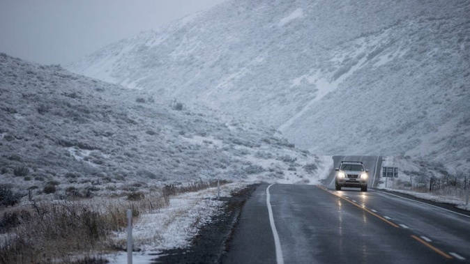
The chances of snow to sea level in the South Island appears to be increasing with MetService now reporting it could be possible next week.
A spokesperson for the forecaster said a cold, dry airmass is expected to move over the south on Monday bringing low snow and southwest gales to the Southland and Otago regions.
"With this polar blast snow as low as sea level is possible for the lower South Island on Monday as cold air muscles its way north," they said.
According to Blue Skies Weather and Climate Services, a southwesterly airstream will spread over Canterbury on Monday and become progressively colder as a trough of low pressure deepens east of the South Island.
On Monday afternoon, snow showers are expected to lower to 500m on the Canterbury hills.
Three to five centimetres of snow may accumulate above 700m, while a few centimetres may fall above 500m.
"Snow may fall just low enough to make Alpine passes marginal late on Monday but significant falls are not expected. Travel on higher parts of Banks Peninsula may be impacted by snow later on Tuesday."
On Tuesday, the forecaster is predicting, a period of showers will spread along the coast during the afternoon and evening with snow showers possible to near sea level on Banks Peninsula.
But there is only a small chance of snow flurries across the eastern suburbs and Port Hills of Christchurch city, they said.
"A few centimetres of snow may briefly accumulate on the Banks Peninsula above 200m."
According to Metservice, a rain-making front is expected to cross the South Island on Friday then gradually over the North Island during the weekend.
Rain watches and warnings are in place for the entire west coast of the South Island as the front moves north from Friday evening.
A heavy rain warning has been issued for Buller, Westland south and north of Harihari, the Canterbury headwaters about and south of Arthur's Pass, the headwaters of the Otago lakes and Fiordland.
A strong wind watch is in place for Wellington, Wairarapa, and the Marlborough Sounds as well as the Canterbury High Country.
"Due to the front stalling over central New Zealand on Saturday persistent rain can be expected over western areas between Taranaki and Buller before eventually shifting further north."
The spokesperson said it looks like another wet and windy weekend for Wellington is on the cards.
Take your Radio, Podcasts and Music with you