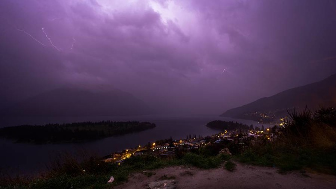
Fierce thunderstorms are marching up the South Island, unleashing a staggering 10,000 lightning strikes in just two hours.
The spectacular storms, which are working their way up the West Coast, started in Fiordland around midnight and have continued relentlessly, turning night to day for those living in the far south.
On the other coast Dunedin was already sweltering above 20C at 6am as sizzling heat from Australia started to warm up eastern regions before dawn.
Southern night skies are being constantly illuminated as lightning bolts flash 45 times every minute.
MetService forecaster Tom Adams said there had been more than 26,000 lightning strikes in the past 12 hours across the west of the South Island.
The constant barrage has made for a sleepless night for many.
A noisy night on the West Coast. Lightning risk reduces this afternoon - see https://t.co/BZWb7ZPiRd. ^TA pic.twitter.com/aZ7EPPTprJ
— MetService (@MetService) September 24, 2017
Queenstown resident James Allan said it was hard to imagine anyone managing to sleep through the storm in Otago and Southland with hundreds of flashes between midnight and 6am "turning night to day".
@MetService Storms slowly spreading Nth along the SI west coast. Lightning strikes now approaching the 10,000 mark over past 2 hours. ^NZ pic.twitter.com/emq0koZmZF
— MetService (@MetService) September 24, 2017
MetService said the storms would continue to affect the entire West Coast today with rain and wind warnings issued for much of central and southern New Zealand.
Heavy rain is expected to drench parts of the West Coast and Tararua Ranges north of Wellington for the next 36 hours.
People are being warned to watch for flooding and slips, with waterways expected to rise dramatically and driving conditions becoming hazardous.
Adams said lightning and thunder would continue to lash the West Coast for the rest of the morning before starting to ease off a little after lunch.
Strong damaging winds are expected to barrel through eastern regions of both islands for the next two days.
The winds are expected to gust up to 130km/h in Wellington and top of the South Island from dawn until mid-morning tomorrow.
The powerful and damaging gales will be felt as far south as Southland and Stewart Island.
Travel is starting to be disrupted with ferry sailings across Wellington Harbour now reduced because of deteriorating conditions and drivers heading over the Rimutaka Hill Rd warned to watch for strong wind gusts.
STRONG WINDS: #SH2 Rimutaka Hill. Please #TakeExtraCare, especially if you are in a high-sided vehicle or on a motorcycle. ^EL pic.twitter.com/YqBKKki1fn
— NZTA Wellington (@NZTAWgtn) September 24, 2017
A storm warning is in force for Cook Strait with winds of just under 100km/h expected to whip through the channel after lunch.
Last nights flights in and out of Dunedin Airport were delayed and cancelled due to high winds.
Northern New Zealand will today remain unscathed by the ferocious conditions today with balmy temperatures in the 20s.
Today's forecast
Auckland: Morning cloud, then fine. Northwesterly winds. 20C
Hamilton:Cloudy, evening showers. Northwesterly winds. 19C
Tauranga:Morning cloud becoming fine. Northwesterly winds. 21C
Wellington:Rain, gales.15C
Christchurch:Cloudy, strong northwesterlies. 23C
Dunedin:Fine, apart from brief morning rain. Strong gusty winds in morning. 21C
Take your Radio, Podcasts and Music with you