Southern roads are starting to disappear under floodwaters as widespread rain and thunderstorms sweep across the country today, and some of the heaviest falls in northern regions are coinciding with holidaymakers travelling home.
Two hundred people are stranded after the rising water of Silverstream cut off the Whare Flat Folk Festival, northwest of Dunedin, today.
Festival organiser Kathryn Olcott said this afternoon that the ford in Silverstream Valley Rd is closed and festival-goers at the site would be unable to leave until tomorrow morning.
Highways across Otago are now affected by flooding as intense overnight rain is causing rivers to break their banks and spill over roads, making them impassable.
Flooding and slips have closed State Highway 6 between Kingston and Frankton and motorists are being forced to travel 50km/h through waterlogged roads on SH87.
/cloudfront-ap-southeast-2.images.arcpublishing.com/nzme/KLEHX7X3UXNLWKN2NJUQXRPXFI.jpg?width=673&height=505&mode=max)
Floodwaters threaten to surge over Patearoa Bridge in central Otago. Photo / Central Otago District Council
MetService is warning a further 100mm of rain is expected into the night in the already saturated coastal Otago.
Sandbag stations are now being set up in Dunedin with rain continuing to fall in the southern city.
As thunderstorms start to rumble overhead in the North Island, the forecaster says there is a risk of rivers and streams rising rapidly even if there is no rain overhead.
A severe thunderstorm warning was issued for the Far North at 2pm with severe thunderstorms detected bearing down on Kawakawa, Moerewa and Opahi.
MetService said the storms were travelling northeast and expected to lie near Kawakawa, Pahia, Moerewa, Opua and Waihaha by 3pm.
The thunderstorms were expected to be accompanied by heavy rain and the likelihood of flash flooding and extremely hazardous driving conditions.
Water from the rising Waitaki River is now surging over SH83 between Georgetown and Kurow and SH82 between Ikawai to Kurow.
Environment Southland has activated its flood warning systems. The upper reaches of the Waikaia River are currently affected.
Campers across the region are being warned to head to higher ground and motorists throughout the south are advised to drive to the deteriorating conditions.
This afternoon nearly the entire North Island was under a severe thunderstorm and heavy rain watch, with threat of lightning, rumbling skies and intense localised downpours.
The storms are not expected to ease until night.
Earlier this afternoon MetService said there had been 323 lightning strikes over the North Island. This was expected to ramp up as storms developed across the island in coming hours.
MetService has issued a number of heavy rain and thunderstorm watches and warnings for parts of Canterbury and Otago, and ranging from the eastern Tararua District to Northland.
It warned the storms were slow moving and with the large amounts of rain expected to fall, there was a threat of flash flooding with rivers and streams expected to swell rapidly.
Overnight rain had already forced the Central Otago Trotting Club to cancel today's race meeting after floodwaters inundated the carpark and racecourse.
/cloudfront-ap-southeast-2.images.arcpublishing.com/nzme/EBHUV54GLZQMHGPXVOD7TTY7GI.jpg?width=809&height=545&mode=max)
The Takarahi Water Scheme pump in Waitaki is inundated due to flooding across central Otago. Photo / Waitaki District Council
A number of other big events around the region have also been affected by heavy overnight rain including The Gate Lake Dunstan Triathlon and Duathlon, which has been postponed for safety reasons, and the Cromwell Wine and Food Festival, which is now cancelled.
However, the Wanaka rodeo is due to go ahead as planned.
The worst of the wet weather in the north is forecast for central and eastern areas of Northland south of Doubtless Bay and Taupō, eastern Waikato and the Coromandel Peninsula south of Whitianga.
At 7am, showers were already starting to fall across western regions from Auckland to Marlborough and the first thunderstorm of the day was tracking closely behind off the Tasman Sea.
MetService is warning the turbulent overhead conditions will blanket much of the north across the afternoon and evening.
MetService said daytime heating and afternoon wind convergences were expected to produce showers and possible thunderstorms around the central parts of the North Island, from Coromandel Peninsula to Hawke's Bay and the Tararua District after lunch.
At times, there will be intense downpours of up to 40mm of rain in an hour.
It warned of the risk of flash flooding, especially around low-lying areas such as streams, rivers or narrow valleys, and slips. Driving conditions are also expected to be hazardous, with flooding and poor visibility during downpours.
The forecaster warns there is even a chance tornadoes and hail will strike in the South Island over south Canterbury and central Otago. However, the risk of such severe conditions remains low at this stage.
It expects the wet weather to continue in the North Island on Sunday, with the possibility of heavy and thundery showers in the afternoon in the north and east, eventually clearing to fine in the southwest in the evening.
In the South Island, rain is forecast on Sunday in the south and west and about the Canterbury high country, and easing in the evening.
Showers are still expected across the country into Monday, but there will be some fine spells for the North Island on Tuesday.
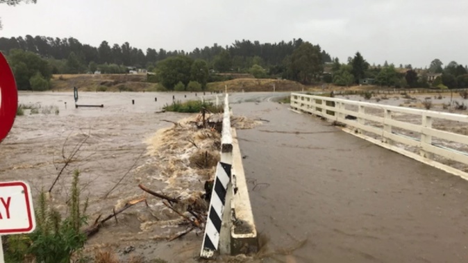
/cloudfront-ap-southeast-2.images.arcpublishing.com/nzme/LQGNKHM7P2CCAJYWEGMZM3HC6Y.jpg?width=689&height=517&mode=max)
Danseys Pass Road is closed due to flooding. Photo / Central Otago District Council / Fulton Hogan
Take your Radio, Podcasts and Music with you