The path to the firewood pile will be starting to get well worn by now, and the bad news is, this cold snap looks like it will persist for a while longer.
Queenstown, in particular, is feeling the effects.
Temperatures at the resort's airport have not exceeded 10degC in the past six days and the most recent forecast shows it could remain in the single digits for the next 10 days.
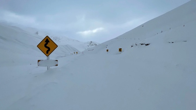
The Crown Range remains closed from the Eastburn Gates through to Cardrona this afternoon. A spokesman for the Queenstown Lakes District Council said an avalanche assessment was completed yesterday, and road crews were working to clear "an impressive amount of snow" from the road from early today.
The alternative route via State Highway 6 and the Kawarau Gorge is open.
"While it might be a bit warmer and drier today, there are still going to be patches of ice lurking out there and plenty of grit too, so drive with caution. Extra care is required in shady spots and when crossing bridge decks."
Meanwhile, the top section of the Tiki Trail will be closed over the next few days due to recent snowfall and icy conditions, QLDC advised today. An alternative route is via the Skyline access road where people can then rejoin the Tiki Trail. Signage is in place.
The Lindis Pass (SH8) has been gritted, but there are still patches of ice around so extra care is required if using that route today.
In Central Otago, the Danseys Pass Road was closed due to snow on the Waitaki side, but reopened this morning. However, the road is restricted to four-wheel-drive vehicles (from the gates past the Danseys Pass Hotel).
MetService meteorologist Lewis Ferris said the average June temperature for Queenstown was 9degC, but it was unusual for the temperature to remain in single digits for so long.
"Usually we'd have a run of southerly winds and then they would turn around to the north and bring a day or two of warmer temperatures before the next southerly arrives. We're not seeing that at the moment."
Ferris said the southwest shift in wind direction was keeping a persistent flow of cool air across the country, alongside a heavy snow watch for southern Central Otago, Clutha and much of Southland and Fiordland today.
He said snow was expected down to 300m, with periods of heavy snow possible above 400m.
Snow amounts may approach warning criteria above 400m, he said.
Cardrona skifield had been expected to open today but has pushed it back to tomorrow. Coronet Peak was scheduled to also open tomorrow.
Winds gusted up to 131kmh in parts of Otago and Southland yesterday, and strong wind warnings and watches were still in force around the region today, where severe west to southwest gales could gust up to 120kmh in exposed places.
The winds were expected to ease off tomorrow and Friday, he said.
Take your Radio, Podcasts and Music with you