Auckland motorists are being urged to prepare for packed roads and slow-moving traffic today as forecasters warn the flood-ravaged city could be hit by another fierce weather system later this week.
MetService has “all eyes on the islands” as a tropical low that may turn into a cyclone threatens to breach New Zealand’s shores in the coming days.
“If this system does pass close to the North Island, it will be another significant weather event potentially affecting vulnerable areas which are still recovering from recent severe weather,” MetService said yesterday.
A potential cyclone is the last thing Auckland needs as residents across the city continue to clean up after unprecedented rainfall sparked severe flooding that inundated homes, triggered numerous slips and claimed the lives of four people late last month.
And with the return to school and work after the long weekend, Tuesday is expected to be a busy day for the Auckland Transport network.
Motorists are being asked to prepare for this accordingly by planning ahead and leaving plenty of time for travel this morning.
AT spokesman Darek Koper said AT will be providing regular updates on its website, so people have the information they need to plan their journeys.
As of last night, 29 roads were still closed or partially closed across Auckland due to the widespread damage caused by the devastating floods.
Slip-ravaged Tāmaki Drive is expected to open with one lane soon, while Ngapipi Rd in Ōrākei, Shore Rd in Remuera and Kemp Rd in Massey have reopened, Auckland Emergency Management said.
/cloudfront-ap-southeast-2.images.arcpublishing.com/nzme/2LUFUM5LURCEDBAQYP4MMH77GQ.jpg)
Workers are clearing a large slip on Tamaki Drive between Okahu Bay and Mission Bay. Photo / Dean Purcell
AEM said work continued yesterday reconnecting the city after slips and floods impacted roads and a bridge was washed away in Rodney.
AT and contractors aimed to have a new bridge on Mill Flat Rd, near Riverhead, fully open by Wednesday. AEM said it was trying to open the bridge to residents yesterday.
“Be prepared for longer journey times due to more Aucklanders travelling around and the remaining damage to our road and public transport network,” Koper said.
He confirmed that scheduled buses will be operating as usual from today however there may be some last-minute cancellations due to the ongoing bus driver shortage.
He advised that people may want to consider walking or biking to school or work, but MetService warns that may not be possible all week as a fresh cyclone threatens to bring more rain to Auckland.
It is expected to hold off today, however, with Auckland likely to see a mainly fine, 24C day with some isolated showers in the west.
MetService meteorologist Jessie Owen said that the upcoming week would bring milder temperatures across the nation and a break from the humid and sticky weather in the north.
However, the finer weather could prove to be brief.
“All eyes are now on the tropics,” MetService said.
A cyclone was likely to develop in the Coral Sea, between New Caledonia and Australia in the Pacific, from a tropical low-pressure system in the next few days.
Windy.com predicts on its website that the storm will likely hit our shores at midnight next Monday, bringing strong gusts up to 50 knots.
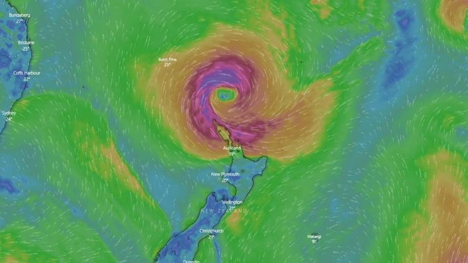
/cloudfront-ap-southeast-2.images.arcpublishing.com/nzme/A57HWE5V3JCYVC6QXUIWC55P64.JPG)
Weather forecast chart from Windy.com showing a Tropical Cyclone over the north island of New Zealand at midnight 13/14. Photo / Supplied
Forecaster WeatherWatch said more slips, more flooding and more road closures are inevitable if this storm directly tracks over New Zealand.
“This likely storm has the potential to bring with it 300mm or more to NZ, so that precise tracking - whether it makes landfall or remains out at sea - is even more critical following recent flooding,” WeatherWatch head forecaster Philip Duncan said.
“It is certainly one to closely watch and many will be hoping it remains out at sea, which is a possibility.”
Hauraki Gulf Weather explained the “convective hot towers punching into the stratosphere” were likely to become a tropical cyclone on Wednesday.
The forecaster said it was “still early days and a lot can change” but called current tracking a “concerning trend for the upper North Island”.
The potential tropical cyclone was expected to “possibly [move] towards the far north of New Zealand” at the weekend, MetService said.
The storm could cause strong winds, heavy rain and large swells on the country’s eastern coasts, should it pass nearby.
“It is important to emphasise that the cyclone’s path is still uncertain as the system hasn’t yet developed.
“We will have a much better idea about the path this system will take, and any related severe weather, in another couple of days once it has formed,” Owen said.
Take your Radio, Podcasts and Music with you