Awakening to the raw soundtrack of roiling ocean breakers and the gentle pitter-patter of a pre-dawn shower, I was up with the seals to strike out along the coastal trail at Cape Foulwind. History runs deep here, as it was where Abel Tasman first dropped anchorage in New Zealand in 1642 and the cape earned its name from the atrocious howling weather that greeted James Cook on his voyage in 1770. It’s also the closest point to Australia.
The sweeping panoramas are stupendous. I gazed north along the coastline to the strikingly sculpted cliff-backed beaches at the northern end of the cape. Omau Cliffs, where hard granite intersects with softer mudstone, glow a golden hue in the sunshine. Once nicknamed the Scarborough of New Zealand, they remain a favourite shoreline haunt in the summer. To the east, the inland ancient marine terraces rise up to the Paparoa Ranges, while patches of pakihi were readily conspicuous. This widely adopted Maori name in Buller denotes stunted vegetation on swampy ground.
On a clear day, Mt. Cook serrates the southern skyline, while the Kahurangi National Park rises up to the north. Scores of weka were nonchalantly grazing in the trackside scrub. Unlike most of New Zealand, Buller is one of the few places where you’ll regularly encounter them. Friendly and flightless, they are fleet-footed. One of them ventured out on to the road just as I was bearing down. I have never seen a bird scramble so frantically, on foot, in a mad mercy dash.
The 90 minute coastal walk from Cape Foulwind to Tauranga Bay passes along the edge of an escarpment, where the granite bluffs serve up monster views of the rugged coastline. I cheated and drove around to the beautiful golden sweep of Tauranga Bay, a surfies haven, taking the shorter track from the car park to the seal colony. The 10 minute walk up the headland leads to the lookout points of the seal colony, draped across the wave-battered rocks, below.
Beyond the shoreline, a rocky outcrop called Wall Island is like a satellite town to seal city, and the thoughtfully mounted free-to-use binoculars, provide magical glimpses of the playful fur seals enjoying some island time. Tauranga Bay is one of New Zealand’s most accessible fur seal colonies and over summer, the place is teeming with frolicking pups. Pointing the car north, I ventured up the highway, past Westport, to Waimangaroa.
I fondly recall my first family holiday to the West Coast when I was seven. We stayed at Waimangaroa and visited the Denniston coal-mine, where a worker gifted me an old vivid blue miner’s helmet. I still have it. Following the signposts, I drove up to the top of the 700 metre plateau, where only a few scratchings remain of what was once a bustling mountain village, a coalmining community living in the clouds. At its peak, Denniston was home to 1500 residents, just over a century ago.
The starring attraction is the Denniston Incline, one of New Zealand’s greatest engineering feats, which opened in 1879. This fantastically steep rail track system, which tilts at 45 degrees, was built to carry coal from the Rochfort Plateau down to Conn’s Creek, 518 metres below. Empty coal wagons were hauled back up the slope by the weight of the descending loaded wagons. It was a counter-balancing triumph and the only way in and out of Denniston until the road was built in 1900.
Not only did it transport coal, but people, furniture and all manner of goods. An old family friend who grew up in the area recalls riding the wagons as a weekend pastime, as a child. The clipboard police from Worksafe would have a fit, in this day and age! The Denniston Incline finally closed in 1967, but many vestiges of its guts and glory remain in situ, including the huge brake drum and some of the wagons at the top of the incline. In addition to taking in the ghost-town wistfulness of Denniston, the far-reaching views across the region and coast, from the lofty plateau are incomparable.
I headed further north to Mokihinui and over the bush-clad heights of the dramatically scenic Karamea Bluff, thickly draped in rimu and matai forests. More expansive vistas of the pounding Tasman Sea unfurled before me, before I descended into the coastal lowlands of Little Wanganui. Purring across the flat terrain, a roadside billboard was emblazoned with the greeting: Karamea – Welcome to Paradise. Lush and velvet green pastures, backdropped by jagged ranges, thickly carpeted in native forest, is my kind of paradise.
Relaxed, embracing and unhurried Karamea amplifies the sense of idyllic solitude. A smattering of art and craft studios grace the main street of the West Coast’s northernmost settlement, no doubt inspired by Karamea’s soul-soothing natural landscapes. On the doorstep of the Kahurangi National Park, as the warm spring sun blazed down, I took the short drive to the Karamea end of the Heaphy Track. A sublime little taster of one of our Great Walks can be enjoyed by taking the Nikau Grove walk.
Starting from the gnarly old swingbridge that traverses the Kohaihai River, the 40 minute walk ushers you into a lush heart-stealing forest of palms, headlined by thousands of Nikau palms. With rigid fronds forming a uniform fluted shape, they’ve long been my favourite New Zealand tree. Another great short walk is the 90 minute return romp to sun-kissed Scott’s Beach. One final experience on my itinerary was a rendezvous with the Oparara Basin.
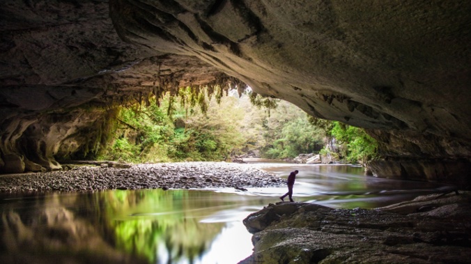
Close to the Heaphy Track carpark, McCallum’s Mill Rd is the route you’ll need to take. This old logging road, narrow, steep, unsealed and winding, is not for the faint-hearted. But the 15km ordeal is undeniably worth it. The surrounding karst landscape is mantled in primeval rainforest and is home to a beguiling network of caves and spectacular limestone arches. From the carpark, an easy 45 minute return leads you to the big-gun attraction, the Oparara Arch, New Zealand’s largest natural arch, spanning 200 metres in length and 37 metres in height.
It’s a celestial spectacle, dry and roomy inside, with stalactites and stalagmites. There’s been talk of “Disney-fying” the arch, festooning it with a coloured light show. Please God, no. This glorious limestone creation towers above its namesake river, which slinks through its wondrous limestone landscape, wrapped in magnificent podocarp forest, particularly kahikatea trees - the food basket of the forest, prized by native birds for its fruit and seeds. The walk along the fertile limestone terraces also features matai, red beech and silver beech trees, towering above a mossy, fern-filled understorey.
Rata, kamahi and rimu are also present in this drop-dead gorgeous valley. The native birdsong is diverse, cacophonous and notably louder than what you typically here. Like the Kohaihai River, the Oparara’s water is a tea-stained, due to the tannin leaching from decomposed leaves on the forest floor. It’s a common feature in forest areas that incur high rainfall. After a retina-burning day of scenic overload, my charming roost for the night was the Karamea Village Hotel.
This award-winning country hotel, wrapped in splendid gardens, is a beloved and fully restored Buller landmark, offering fully-serviced accommodation units and hearty fare. A beacon for hospitality since 1876, it’s a treasure. Whether you’re dining beside the open fire or al fresco, the honest-to-goodness home-cooked cuisine wins plenty accolades. Whitebait, anyone? www.karameahotel.co.nz
For more regional touring tips in this remarkable pocket of New Zealand, head to www.westcoast.co.nz
Mike Yardley is our Travel Correspondent on Jack Tame Saturday Mornings.
Take your Radio, Podcasts and Music with you