UPDATE 12.33PM: Most of the North Island's coastline is at risk of flooding as a sub-tropical storm whips up ferocious seas combined with the biggest tides of the year.
Niwa is warning the approaching storm is bearing similarities to ex-Tropical Cyclone Ita, which struck at Easter three years ago inundating coastal communities across the upper North Island and blowing buildings to pieces on the South Island's West Coast.
Heavy rain warnings are now in place for Auckland, Northland, Coromandel Peninsula, Bay of Plenty, Rotorua, Mount Taranaki, Nelson, Marlborough, and the Kaikoura Coast.
Currently building off north eastern Australia, the low pressure front will hit New Zealand's north on Thursday, dumping 70-90mm of rain on Auckland between midday and midnight, the MetService says.
The Super City is also expected to experience winds gusting up to 120 kilometres per hour.
Strong winds will also buffet Northland, Great Barrier Island and Coromandel Peninsula, possibly damaging trees and powerlines and making it hazardous on the roads for tall trucks and motorbikes.
Waves up to 7m high are expected to hammer all North Island coastlines.
The low pressure front will then travel south on Thursday bringing heavy rainfalls up to 150mm-and-160mm on Bay of Plenty and Mt Taranaki before hitting the top of the South Island in the early hours of Friday.
The front is expected to clear the country by Saturday. The country's forecaster is warning the significant weather system has the potential to bring severe weather to northern and central New Zealand.
Weatherwatch.co.nz head analyst Philip Duncan said the storm would rapidly deepen and intensify before it made landfall tomorrow.
Campers and trampers were warned to be aware of the deteriorating conditions. The storm was expected to bring torrential rain, widespread strong to gale-force winds and dangerous sea and beach conditions around the North Island.
Duncan said models showed the storm was expected to peak early Friday. A wind map put the worst of the winds becoming hurricane force - 120 km/h - for a time at the centre but such winds would stay mainly out at sea.
A turbulent end to the week is on the cards with a low expected to affect the North Island from Thursday & the upper South Island into Saturday. Heavy rain & strong/gale winds are expected with this system - keep updated at https://t.co/hnwmGxU1gR closer to the time ^AC pic.twitter.com/jH7frSHE7g
— MetService (@MetService) January 1, 2018
The North Island is in line for more thunderstorms today when daytime heat will lead to large cloud build-ups and isolated torrential downpours with thunderstorms.
Bay of Plenty and Gisborne, western North Island areas from Waitomo to northern Manawatu are at greatest risk along with regions at either end of the South Island.
MetService says any thunderstorms that develop will be slow-moving and have the potential to produce localised heavy rain or downpours.
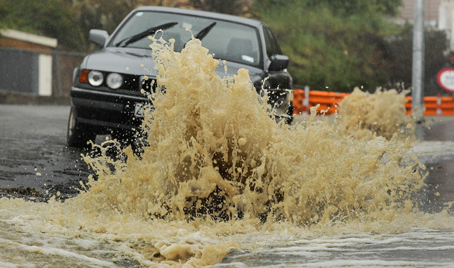
The rain could be so intense people are being warned to expect up to 40mm in one hour in western and central North Island.
The forecaster says this level of drenching could lead to flash flooding and make driving conditions extremely dangerous.
A significant sub-tropical rain+wind storm is still expected to impact the North Island and mid-upper South Island on Thursday-Friday.
— NIWA Weather (@NiwaWeather) January 2, 2018
The model infrared satellite imagery showing the system's origin in the Coral & Tasman Sea and strengthening en route to NZ. pic.twitter.com/GRPnpuKrfu
Duncan said the approaching storm was likely to cause very dangerous marine conditions, bringing strong rips and mountainous seas affecting western and eastern coastlines of the North Island.
He said those near streams should be prepared to move to higher ground should the low produce flooding rains, which is possible in some spots - especially after such a long dry end to spring and start to summer.
Take your Radio, Podcasts and Music with you