Lap up the fine weather this weekend as three days of heavy rain that could see flooding and further slips in already saturated parts of the country are just around the corner.
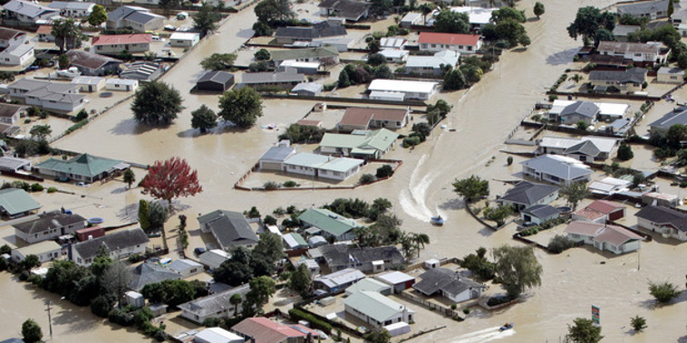
Water levels have dropped in the flood-ravaged town of Edgecumbe, however the town remains on high alert for more rain.
Approximately 1600 evacuees are left not knowing when they will be allowed home to the Bay of Plenty town.
MetService meteorologist Peter Little said the next few days would be mostly settled with a few showers. But heavy rain fuelled by moist subtropical air was set to move over the country late on Wednesday and could stick around to Friday.
Little said Thursday would cop the wettest weather and northeastern areas - from the Bay of Plenty to Northland - would see the worst of it.
"Saturated areas will have some chance to dry out, but it looks like they will get wet again."
A tropical cyclone is developing northeast of Vanuatu. Little said at this stage it is looking likely to avoid New Zealand but there is the possibility it could head to our shores in time for next weekend and the start of the school holidays.
Weatherwatch.co.nz is describing the week leading up to Easter as another serious week for the country with the potential for more significant rain and the risk of further slips and flooding.
Niwa meteorologist Ben Noll said this week's significant weather appeared to be remarkably similar to the previous "Tasman Tempest" storm that saw Auckland and Coromandel inundated by flooding.
"It's fairly similar to the last two but it is unclear where the heaviest rain is going to happen," said Noll.
"It's set up very similar to the Tasman Tempest and the last two large storms."
It was likely to bring big rain to parts of the country even threatening to repeat levels recorded during this week's phenomenal rainfall, Noll said.
"I would say it's not out of the realm of possibility. Some places will see hefty amounts of rain but that depends on the tropical connection and intensity of the storm itself."
He said most of the North Island and upper and eastern parts of the South Island would be affected by next week's deluge. The storm would also usher in another week of sticky, high humidity.
Weatherwatch.co.nz forecasters warned while the storm was not as tropical as the remnants of Debbie it may still be packed with heavy rain and slow-moving enough to cause flooding.
But the Easter forecast looked far more ominous with a second possible cyclone tracking directly towards New Zealand in what would be an extraordinary week of back-to-back storms.
Noll said they were keeping a close eye on the tropics where a disturbance northeast of Vanuatu was expected to form into a tropical cyclone.
Weatherwatch.co.nz said while it was too far out to lock in reliable computer models had picked these storms to form for several days now and there appeared to be a zone around New Zealand suitable for at least two of three lows to merge.
Take your Radio, Podcasts and Music with you