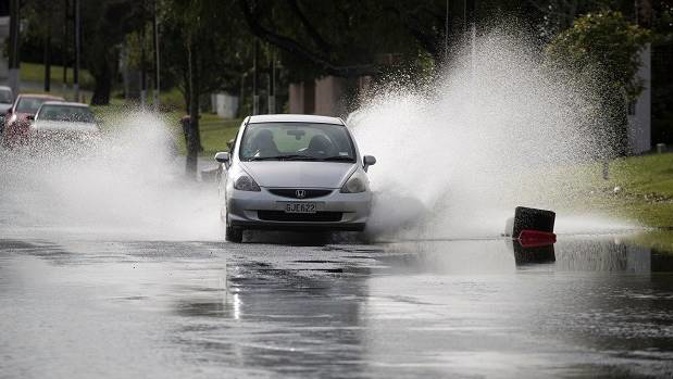
Thunderstorms and heavy rain are battering parts of the North Island this morning marking a wild start to the week.
A low pressure system was moving first on to North Taranaki from the Tasman Sea, MetService meteorologist Brian Mercer said.
Up to 100mm of rain is expected about Mt Taranaki, and 60 to 80mm elsewhere by 11pm.
Taranaki, Waitomo, Taumarunui and western Waikato were under a severe thunderstorm watch, with potential for downpours of 25 to 40mm/h and possibly a small coastal tornado.
Air New Zealand has issued a warning the severe weather could disrupt some flights.
⚠️ Weather conditions may disrupt flights across the upper North Island this morning. Stay updated on your flight here 👉 https://t.co/rXQtFJPdCD
— Air New Zealand✈️ (@FlyAirNZ) June 17, 2018
Showers and rain were forecast across most of the central North Island and top of the South Island today.
Further north in Auckland, Northland and the Bay of Plenty, showers could become heavy late morning, with possible thunderstorms.
A good line of showers and thunderstorms moving in from the west. Although most of the thunderstorm activity is centred around #Taranaki, expect some heavy showers for #Auckland later this morning. https://t.co/7k3nmdWQwx ^TA pic.twitter.com/iMV5ODzhZ6
— MetService (@MetService) June 17, 2018
Temperatures will be mild however, with Whangārei forecast to hit 19C, Auckland 18C and Tauranga 17C. The mercury drops further south, with Hamilton in for a high of 16C and Wellington 13C.
In the South Island, the West Coast is in for a relatively fine day while the east coast will be "quite unpleasant".
TROUBLE BREWING IN THE TASMAN
— MetService (@MetService) June 17, 2018
Convection and surface lows mid-Tasman move over NZ today. Several rainy days + chance of thunder to start the week, except in the far south. Then colder temps from Weds, but rain clearing off for the end of the week. https://t.co/Yjbq0jxdqz ^TA pic.twitter.com/JfHZNtKvC8
"There will be a lot of low cloud most of the day in eastern areas, with patchy drizzle about the coast this morning spreading over the whole east coast through the day," Mercer said.
Christchurch and Dunedin will struggle to make it into double digits today with highs of just 10C.
A wet Monday in store for much of the North Island and very top of the South Island.
— NIWA Weather (@NiwaWeather) June 17, 2018
* A soggy morning commute possible in western areas
* A line of heavy showers in Auckland and Hamilton midday
* A good soaking rain possible for Wellington and Nelson
* Most areas drier late-day pic.twitter.com/8O3JjRdEBO
The unsettled weather will continue through the country tomorrow.
A weak front moves up the South Island, continuing the drizzle on the east coast.
Cold temperatures are expected across the country for much of the week, with highs in the early teens for the North Island and single digits for the South Island.
A cold night in store, with many places heading for the single digits. https://t.co/hnwmGxU1gR ^CD pic.twitter.com/8g7ICWMgSI
— MetService (@MetService) June 17, 2018
A ridge of high pressure is forecast to build on Wednesday in the South Island, bringing periods of fine weather for the latter half of the week.
Meanwhile, the low affecting Taranaki today moves over the northern North Island tomorrow, spreading the heaviest rain there.
Rain will ease by tomorrow afternoon in lower and central areas, and by Wednesday in the Far North.
The ridge of high pressure will build into the North Island by Thursday and Friday, bringing a fine end to the week for most of the country.
Today's weather
• Whangārei
Showers, possibly heavy and thundery, easing in the afternoon. Northwesterlies. 19C high, 11C overnight.
• Auckland
Showers, possibly heavy and thundery, easing this afternoon. Northwesterlies. 18C high, 11C overnight.
• Hamilton
Periods of rain developing morning, some heavy and possibly thundery, easing towards evening. Northerly. 16C high, 8C overnight.
• Tauranga
Rain developing morning, chance heavy and thundery, easing towards evening. Northwesterly dying out overnight. 17C high, 10C overnight.
• New Plymouth
Rain with possibly heavy and thundery falls. Northerly turning southeast overnight. 16C high, 8C overnight.
• Napier
Occasional rain developing morning, clearing evening. Northerlies. 15C high, 6C overnight.
• Wellington
Rain setting in during the morning with possibly heavy falls. Northerlies turning southerly afternoon, then strengthening evening. 13C high, 8C overnight.
• Nelson
Occasional rain developing this morning. Light winds. 14C high, 5C overnight.
• Christchurch
Mostly cloudy with patchy drizzle, becoming widespread afternoon as southerlies develop. 10C high, 6C overnight.
• Dunedin
Low cloud. Occasional drizzle and cold southerlies developing afternoon. 10C high, 6C overnight.
Take your Radio, Podcasts and Music with you