If you thought yesterday's rainfall in Sydney was heavy, welcome to Thursday.
By 9am, the city had reached its average total of rainfall for an entire year - a whole nine months ahead of schedule.
More than 1214mm of rain has already fallen on the city, with even more set to come.
The inclement weather has led to warnings that major suburbs in the city's west, including Liverpool, could flood later in the day as swollen rivers burst their banks. Already, train services have been disrupted near Sydney.
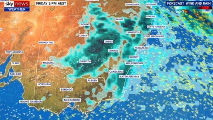
And it's not just Sydney – a vast swath of New South Wales is seeing large falls as far inland as Dubbo and Orange, as well as along much of the coast.
"The rain event has really only just begun," Sky News Weather meteorologist Rob Sharpe said.
"There's still a fair way to go with this event with a lot of rainfall charging into [Australia's east]."
'Serious concern'
The Bureau of Meteorology (BOM) has issued a severe weather warning for heavy rainfall for the entire NSW coast between Newcastle and Bega, near the Victorian border, for Thursday.
At least 100mm is possible in Sydney, the Blue Mountains and down the south coast over the next few days.
"But there's potential for totals of up to around 300mm. So that's why flash flooding is a serious concern," Sharpe said.
The torrential conditions are due to a combination of factors. The La Nina climate driver continues to push warm moist air towards the continent. At the same time, cooler than usual air is high in the atmosphere and that's causing the warmer moisture to rise and then form clouds and rain – lots of it.
"That's our rainmaking event that is moving through the upper system and that's driving the whole thing," he said.
Grim rain record could be beaten today
On Wednesday, Sydney Airport record 111mm of rain, more than 15mm above its entire average monthly rainfall for April in a single day.
Lucas Heights, in the city's south, topped out at 84mm while the CBD weather station, next to the Harbour Bridge, recorded 86mm.
So far in 2022, Sydney's CBD has seen at least 1112mm of rain. The average annual rainfall in Sydney is 1164mm.
That means if just another 52mm falls on Thursday – and double that is possible – the city will have equalled its usual rainfall for the entire year in just three months and one week.
Thunderstorms are also possible but the intensity of the rain should lessen going into Thursday evening and Friday. It's likely the big wet will subside over the coming days – at least for now.
It's much the same story throughout other parts of Sydney, with Penrith in the west also set to see 60-100mm and then between 20-30mm on Friday and spells of less heavy rain through the weekend.
Minor to moderate flooding is possible on the Nepean, Hawkesbury, Colo, Georges and Woronora rivers in and around Sydney with flooding very possible in riverside suburbs such as Liverpool, Milperra and Menangle.
At 6am on Thursday, buses were replacing trains between Thirroul and Waterfall on the NSW Train Link South Coast line due heavy rain at Helensburgh.
Much of NSW set to be smashed
Wollongong could see 70-120mm on Thursday and up to 45mm on Friday; 60mm could find its way down to Bega; up to 170mm could fall on Katoomba over the next couple of days with potentially more than 50mm in Dubbo over the same period.
Blessedly, northern NSW, which has been beset by rain, will be less affected. But rain could still reach places like Byron Bay with falls on Thursday and then 15-35mm on Friday.
Temperatures will be mild in much of NSW hovering around the early 20C mark.
Take your Radio, Podcasts and Music with you