The worst of the Antarctic blast hammering the South Island has passed but it will leave many still shivering tomorrow.
Temperatures will be plummeting as low as 4C in Invercargill tomorrow - but might feel far colder than that as icy southwest winds howl through the city.
Meanwhile warnings of severe gale northwesterlies in Wellington and Wairarapa has seen the Wellington Harbour Ferry cancelled for the rest of the day.
Metlink says replacement shuttles would transport stranded commuters.
Over 2000 residents bore the brunt of widespread power outages across the city, while traffic headaches were intensified after high wind caused a trailer to roll on SH1 Ngauranga Gorge between Tyers Rd and the Newlands off-ramp just after 3pm.
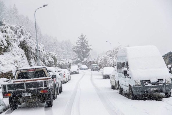
Snow fell on the beaches of Stewart Island and Southland for the first time this year today, as hazardous conditions in the south island saw authorities urge motorists to avoid central roads completely.
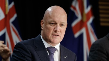
Prime Minister Jacinda Ardern was one of many to have their travel plans thrown into disarray as bad weather swept the south, finding herself stuck in Invercargill.
Ardern's afternoon flight out of the Southland town was cancelled as an icy blast of Antarctic air saw temperatures plummet to the mid-single digits.
Gore and Invercargill saw their lowest maximum temperatures since July this year - at 3C and 4C respectively - while temperatures in the rest of the South Island struggled to rise above 12C today.
MetService meteorologist Lewis Ferris says the bitterly cold snap rounding out August comes courtesy of several cold fronts, followed by an influx of frigid air, bringing snow and single-digit temperatures to many parts of the country.
While the conditions should ease from Wednesday, Ferris said tomorrow morning will dawn especially cold for some.
"Today at Invercargill Airport the maximum temperature was 6.2C and tomorrow morning a maximum of 4C is expected at the airport," he said.
"The low temperatures are aided by the very cold air mist over the South Island, and the presence of snow on the ground really brings down the warmth.
"It's also quite windy there, so wind chill will make it feel bitterly cold tomorrow - in places with snow and forecasted southwesterlies it will get pretty heinous."
Another dusting of snow and wet weather is expected overnight, with black ice on the cards along SH8 from Twizel to Fairlie and SH80 Pukaki to Mount Cook, Mackenzie Country, MetService warns.
Heavy snow has resulted in and out of Queenstown being cancelled or diverted to other parts of the country, while NZTA reported that a number of vehicles have come off the road around Otago and Southland.
Photos of the airport in Queenstown show flight equipment and gear covered in a thick coating of snow, and the backdrop completely white.
A swathe of weather warnings are in place across the South Island, with heavy snow warnings in place for Fiordland and parts of Southland, and snow forecast for Dunedin, Clutha and Central Otago, Nelson west of Motueka, Buller and Westland north of Arthur's Pass.
MetService is also forecasting strong wind in Canterbury, Marlborough, the lower North Island and parts of Hawke's Bay.
Waka Kotahi NZTA senior journey manager Neil Walker said all of the South Island passes were expected to have snow and the only question was how heavy, while the motorway heading north from Dunedin was likely to be affected in the cold snap.
The message for anyone travelling in the South Island was to be vigilant and check weather and road conditions before they set out.
"Conditions can change at short notice so be really vigilant ... if you can avoid travel that's what we'd be recommending."
But Ferris said it was uncommon to see such heavy snow so late in September, well into spring.
"Farmers in Southland will know well that spring snows are common, but we're getting into the latter part of September, past daylight savings so it is getting rarer and rarer," he said.
Meanwhile in Auckland, motorcyclists and drivers of high-sided vehicles were urged to avoid the Auckland Harbour Bridge completely as wind gusts of 75km/h tore through the city.
Walker warned lanes across the bridge would be closed if wind gusts blew 80km/h or higher.
It comes just 10 days after a truck tipped over in freak winds of up to 127km/h, badly damaging a strut on the bridge.
Three lanes in each direction are now open on the bridge, following urgent temporary repairs last week, but it will take weeks for the bridge to be permanently fixed.
A front moving across the North Island will see the temperature drop in the upcoming days, with gusty southwesterlies in Auckland and the temperature dipping to a high of 14C on Wednesday.
Southerly swells are also being whipped up across the South Island and Wellington, with forecasters warning surfers to take extra care.
"We will see some sizable swells, up to a 4m swell with period 14 seconds, which is spot on for the warning criteria in Wellington," Ferris said.
Mid-week conditions will start to simmer down, as a ridge of high pressure sets itself up over the country.
Although things remain on the nippy side, sunny skies and longer days will make the outdoors seem more inviting on Wednesday and Thursday, Ferris said.
Take your Radio, Podcasts and Music with you