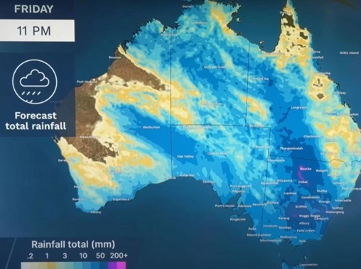
Get set for a soggy slog as the week progresses and into the weekend as possible record-breaking October rain descends, particularly in Australia's eastern states and parts of the Outback.
Sydney could see as much as 100mm of rain over the coming days as multiple fronts bear down.
There are several current minor to major flood warnings across southern Queensland, inland New South Wales and northern parts of Victoria. The wet weather will just exacerbate that.
"It's going to be pretty grim," said one forecaster.
The first wave of rain is set to hit the east coast on Wednesday and that will be followed by at least three further fronts. Sunday could be the wettest day.
"The environment is primed for a significant rain and storm outbreak," said Sky News Weather meteorologist Alison Osborne.
Potentially record breaking Outback rain
On Tuesday, that rain band is working its way east across central Australia, including parts of the Northern Territory and inland Queensland, NSW and South Australia.
"Wednesday will be a heavy day with potentially record breaking rain for October in towns like Bourke.
"And this is turning things pretty grim for flooded catchments with heavy rainfall expected," said Osborne.
On Wednesday, Bourke is looking at 45-60mm of rain and Dubbo up to 20mm. The rain is then set to linger in this inland areas for days. Bourke may see up to 120mm of rain by Sunday, Dubbo 100mm and Tamworth 60mm.
As Wednesday draws to a close, coastal areas such as Newcastle and Sydney and Batemans Bay will then start to see showers.
There will then be a short pause before more pulses of rain start rolling in from the west and the tropics into and across the weekend.
Sydney, eastern NSW looking 'fairly dangerous'
One system could park itself in the Tasman Sea off the NSW coast, bringing even more rain and winds for the state.
"At the moment it's looking fairly dangerous for eastern New South Wales including Sydney," Osborne said, although she stressed the forecast could change in the coming days as the track of the fronts becomes clearer.
Tuesday is the day to put the washing on the line in Sydney with clear skies and highs of 22C.
Up to 20mm of rain could fall in the city from Wednesday afternoon with slightly less rain on Thursday and a few showers on Friday.
But as the weekend comes around, the moisture cranks back up – with up to 25mm on Saturday with possible thunderstorms and 15-35mm on Sunday.
If anything, Wollongong and southern NSW could see even more rain than Sydney.
It's soggy but more manageable in the state's north.
In Newcastle, rainfall totals will likely be lower than Sydney during the week but there's every chance the weekend will be a washout.
Canberra could clock up 30mm of rain on Wednesday and the grey, wet skies will just keep on going into and across the weekend with highs of 15-19C. Anything from 60mm to near 100mm could come down in the capital between Wednesday and Sunday.
Southern inland Qld set to be soaked
Brisbane will see showers but may miss out on the worst of the rain. It will see highs of between 23C and 27C for the coming week and lows in the mid-teens. Rain will be possible most days with heavier falls, approaching up to 10mm on Sunday.
It will be much more unsettled in southern inland areas, however.
Cunnamulla, for instance, could see storms on Tuesday and heavy falls on Wednesday and Saturday. Up to 100mm of rain could fall. Further north, Mt Isa could see 30mm midweek.
It's cloudy in Melbourne for Tuesday. On Wednesday some heavy afternoon and evening falls are on the cards with up to 15mm coming down before clearing on Thursday.
A high on Wednesday of 16C will rise to 21C on Thursday with lows of between 10C and 13C.
The rain then comes back on Friday with another 15mm potentially falling with the weekend mostly moisture free.
Head inland however and those rain totals ramp up. Wodonga is wet and stormy from Wednesday onwards with perhaps a brief sunny interlude on Saturday. Expect 60-85mm to fall between Wednesday and Sunday. Even Mildura could see some heavy falls particularly in Wednesday.
Tuesday will be wet in Adelaide with 10-20mm falling. That should be the worst of it but scattered showers can be expected for the rest of the week. Temperatures will peak at 20C on Tuesday and then 25C on Thursday with mid teen lows.
Hobart will miss much of the heavy rain, although showers will pass through and up to 8mm could fill the gauge on Friday. The mercury will be around 15C, peaking at 20C on Friday and sinking to 7-12C overnight.
But it will be a lot wetter on the northern Tasmania coast. Devonport is looking at 35-65mm between Thursday and Friday.
It will be mostly sunny in Perth with warm days of 20-26C, but chilly nights dipping to 8C. Wednesday is likely to be the wettest day of the week with around 10mm falling. The weekend should be mostly sunny.
Darwin, meanwhile, will be stormy with around 10-20mm of rain possible each day this week and highs in the mid-thirties.
Take your Radio, Podcasts and Music with you