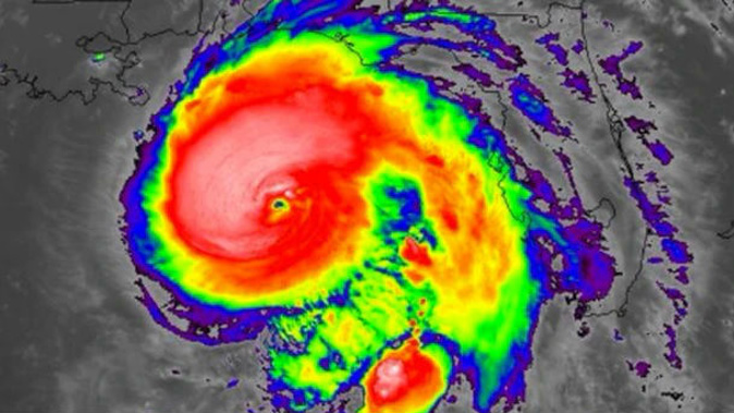
Hurricane Michael rapidly gained strength Tuesday night, threatening to become the most intense hurricane on record to strike the Florida Panhandle.
The storm, now an extremely dangerous Category 4 hurricane packing 130-mph winds, is predicted to make landfall Wednesday afternoon with that same intensity, an event that has never happened in records dating to 1851.
As the storm intensified Tuesday evening, forecasters on Twitter described feelings of sickness and dread.
I honestly have sick feeling in my stomach as I watch and contemplate what to expect tomorrow as #HurricaneMichael intensifies. May be dealing with a strong Cat 3 perhaps Cat 4.....This is not drama or hype, this is simply a meteorologist w/25 years of experience concerned
— Marshall Shepherd (@DrShepherd2013) October 10, 2018
Only a few times in my career at The Weather Channel have I been struck with a total feeling of dread prior to an event... Sandy.... April 27th.... Harvey... & now you can add #Michael to that list. All you can do now is hope people are taking this as serious as they should.
— Mike Chesterfield (@mchesterfield26) October 10, 2018
This is the real deal. Hurricanes that intensify overnight just before reaching land are the worst nightmare of forecasters and emergency managers. https://t.co/AbatBRrNRI
— Bob Henson (@bhensonweather) October 10, 2018
Both Florida's Panhandle, from Pensacola to Apalachicola, and its Big Bend area are forecast to be hardest hit. Water levels had already begun to rise Tuesday and the storm is poised to push ashore a "life-threatening" surge of ocean water that could inundate more than 523km of coastline.
The storm also will bring destructive winds and flooding rain throughout Wednesday.
Population centres that could witness some of the most severe hurricane effects include Fort Walton Beach, Destin, Panama City Beach and Apalachicola.
The surge, or the rise in ocean water above normally dry land along the coast, could reach 2.7m to 4m, inundating roads, homes and businesses. The National Weather Service warned many buildings could be completely washed away and that "locations may be uninhabitable for an extended period" after the storm.
Authorities plead with residents, who had not followed evacuations order, to leave.
Our local offices, emergency management partners and media in Florida are urging people in evacuation zones to move inland IMMEDIATELY. #HurricaneMichael is coming and you're running out of time! We need your help to get this message out. @FLSERT @fema #FLwx pic.twitter.com/cPUFoeWWJp
— NWS (@NWS) October 10, 2018
While the most severe hurricane conditions are expected along the coast, devastating hurricane effects are forecast to expand considerable distances inland.
"A potentially catastrophic event is developing," wrote the National Weather Service forecast office serving Tallahassee and surrounding areas. The office warned of "widespread power outages, downed trees blocking access to roads and endangering individuals, structural damage to homes and businesses, isolated flash flooding and the potential for a few tornadoes."
/arc-anglerfish-syd-prod-nzme.s3.amazonaws.com/public/67XPTEPOYVHY5H6DTETKZAKENU.jpg)
Damaging winds and flooding rain were also predicted to reach southern Georgia and southeast Alabama on Wednesday.
By Wednesday night and Thursday, heavy rains from Michael are likely to streak into the Carolinas, perhaps bringing more flooding to some of the same areas still recovering from Hurricane Florence.
THE LATEST
As of 2 a.m. EDT Wednesday, Hurricane Michael's peak winds were 209km/h, a Category 4, as it moved north at 19km/h. The storm was centered about 180 south-southwest of Panama City.
At Michael's current rate of advance, tropical-storm-force winds should reach the northern Gulf Coast very early Wednesday, after which conditions will deteriorate. Landfall is projected for Wednesday afternoon.
Storm effects
Storm surge
Michael is projected to strike an area that is exceptionally prone to storm surge because of the adjacent shallow shelf water and the concave shape of the coast. Like a bulldozer, the storm will push a vast amount of ocean water inland, potentially inundating homes, roads and businesses.
Areas to the east of where the storm center tracks will experience the greatest storm surge, and flooding will be worse around the high tides.
Storm surges just east of where the center makes landfall could reach 2.7m to 4m if the storm comes ashore around high tide.
Rain
The Hurricane Center projects widespread rainfall amounts of 10cm to 20cm, from the Florida Panhandle and Big Bend areas north into southeast Alabama and southern Georgia, and isolated amounts of up to a foot. "This rainfall could lead to life-threatening flash floods," it said.
Heavy rain could arrive in southern Alabama and southern Georgia early Wednesday. By Wednesday night and into Thursday, heavy rain will rapidly streak through Georgia and into the Carolinas.
Rainfall of 7.6cm to 15.2cm is likely to affect some of the areas recovering from Hurricane Florence in the Carolinas, which could lead to more flooding. Parts of eastern Georgia and southern Virginia may also receive 7.6cm to 15.2cm.
The rain is expected to reach the eastern Mid-Atlantic late Wednesday night into Thursday before rapidly exiting by Friday, where 2.5cm to 7.6cm is most likely, with locally higher amounts.
Wind
Michael's maximum sustained winds are forecast to be around 209km/h when it strikes the coast. Winds this strong will be confined to the ring around its calm eye, known as the eyewall, and "catastrophic" wind damage could occur in this narrow zone. Here is the damage the Hurricane Center describes associated with Category 4 winds:
Well-built framed homes can sustain severe damage with loss of most of the roof structure and/or some exterior walls. Most trees will be snapped or uprooted and power poles downed. Fallen trees and power poles will isolate residential areas. Power outages will last weeks to possibly months. Most of the area will be uninhabitable for weeks or months.
After the storm strikes land, this eye wall will quickly collapse and winds will weaken.
While hurricane-force winds of over 119 km/h will be confined to a relatively small area, tropical-storm-force winds of 62 km/h to 117.5 km/h will occur over a much larger zone and could result in minor structural damage and many downed trees and power outages. The Weather Service tweeted that tropical-storm-force winds "currently extend more than 300 miles across."
A computer model run at the University of Michigan projects about 2 million customers will lose power, the majority in the Florida Panhandle and southern Georgia.
Take your Radio, Podcasts and Music with you