Several Interislander ferry services have been cancelled because of stormy weather in Cook Strait.
Heavy rain and severe southerly gales are forecast for Wellington today, with waves exceeding 5 metres.
An Interislander spokesman said the last ferry to sail from Wellington will leave at 9am and the last sailing from Picton will be at 10.45am.
Affected passengers are being contacted and rescheduled onto sailings tomorrow.
The bad weather has also forced the suspension of the search for a man who fell overboard from a fishing vessel near Wairarapa yesterday.
Wellington's Life Flight rescue helicopter and boats were looking for the man in waters off Cape Palliser yesterday afternoon.
A Rescue Coordination Centre spokesperson says weather conditions are deteriorating and all vessels have left the area.
A decision will be made later today about whether to resume the search.
Bitterly cold southerly blasts up the country are expected to bring rain to most areas and more snow in the South Island.
The better news is the weekend is looking much more settled, although it will be cold.
MetService meteorologist Stephen Glassey said a burst of heavy rain that affected many areas of the North Island yesterday evening came from a fast-moving low pressure system moving east.
The low had travelled to the eastern side of the country, but another trough was due to arrive in the west this morning, meaning a wet Friday for most parts of the North Island south of Auckland. Temperatures would remain relatively mild however, with most places in the mid to upper teens.
About coastal Waikato, southwest Auckland, Bay of Plenty, northern Manawatū, Whanganui, Taranaki, Taumarunui, Waitomo, and even Golden Bay, there was a moderate risk of thunderstorms during the morning.
These thunderstorms could bring localised heavy rain with intensities of 10 to 20mm per hour, hail, and strong wind gusts of 90 to 100km/h, especially from Taranaki southwards.
The severe weather would start to ease in the upper North Island by this afternoon, being replaced by an icy southerly flow dumping snow in the south this morning.
Temperatures have plummeted across the South Island, with Dunedin down to 8C and Christchurch 10C, and most areas doused in rain or showers.
Police are urging Dunedin residents to be wary of icy road conditions this morning, particularly about the hill suburbs, after MetService warned snow could fall to 200m in the city today.
Southern trampers and hunters are also being asked to rethink any planned trips over the weekend because of avalanche risks.
New Zealand Avalanche Advisory head forecaster Jamie Robertson said the danger was not over even as the weather improved.
"The warmer conditions and the wind-loaded slopes mean that in the days after the storm larger 'loose-wet' avalanches that can run to the valley floor are quite possible."
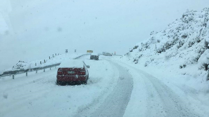
There was a heavy snow warning in force for inland Marlborough and Canterbury, with potential for snow down to 300m, and a dumping of 15-30cm above 500m.
Road snow warnings were in place this morning in the North Island for Desert Rd (State Highway 1) and Napier-Taupō Rd (SH5), and in the South Island for Dunedin to Waitati Highway (SH1), Milford Rd (SH94), Crown Range Rd, Lindis Pass (SH8), Porters Pass (SH73), Arthur's Pass (SH73) and Lewis Pass (SH7).
Glassey said there were no reports in yet of heavy snow but the temperature and snow level would lower through the morning.
The same front could bring strong wind gusts up to 120km/h to Marlborough and Wellington through the morning, and Taranaki later today.
There was also a chance of heavy snow falling above 600m about the central North Island high country including the ranges of Hawke's Bay about the Wairoa District during early Saturday morning.
By Saturday morning the wintry conditions would gradually ease as a ridge of high pressure over the Tasman Sea slowly drifted on to the country, Glassey said.
"Sunday is also looking more settled for most of the country, but it is going be cold."
The ridge of high pressure was forecast to remain slow moving over the country through to Tuesday next week bringing settled weather, however severe frosts and icy conditions on the roads were expected in sheltered inland places.
- Additional reporting: Otago Daily Times
Today's weather
Showers and strong westerlies, both easing in the evening. 17C high, 7C overnight.
Morning rain, heavy for a time, then showers. Brisk westerlies. 17C high, 7C overnight.
Periods of rain, heavy at times, easing to showers afternoon. Strong westerlies turn southerly evening. 17C high, 6C overnight.
Periods of morning rain, chance thundery, then a few showers. Strong northwest, turning southerly late evening. 18C high, 7C overnight.
New Plymouth Periods of rain, chance thundery morning. Strong northerly changing gale southeast afternoon. 16C high, 5C overnight.
Napier Rain at times. Northwest winds change strong southwest this afternoon. 19C high, 6C overnight.
Whanganui Periods of rain, chance thundery morning. Strong southerly change in the afternoon. 16C high, 5C overnight.
Wellington Rain, heavy for a time, easing evening. Strong morning southerly change, with gusts 120km / h in exposed places. 13C high, 5C overnight.
Nelson Showers, clearing to fine during the afternoon. Southerlies developing. 15C high, 2C overnight.
Christchurch Rain, with snow about the Port Hills, easing to showers afternoon. Strong southerlies. 10C high, 3C overnight.
Dunedin Showers, some heavy with snow to 200m, easing evening. Southerlies, strong for a time. 8C high, 4C overnight.
Take your Radio, Podcasts and Music with you