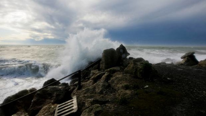
Giant waves - some reaching up to 10m - are set to hit the length of New Zealand's west coast as this week's wild weather continues into the weekend.
A cold front is expected to track northeast across the country today, bringing brief downpours, followed by strong cool southwest winds.
MetService also warned of heavy southwest swells on many parts of the New Zealand west coast today and throughout the weekend which, when combined with strong onshore winds, could create "dangerous surf conditions".
Large southwest swells are expected to affect exposed coasts from Friday through to Sunday, which when combined with strong onshore winds could make for dangerous surf conditions https://t.co/y7sa5NX9NG ^PL pic.twitter.com/V4vMixmHmk
— MetService (@MetService) June 6, 2019
Earlier this week Weatherwatch.co.nz predicted waves today and tomorrow could exceed 10m on west coast beaches.
"Those in Auckland are advised to avoid fishing on the rocks in the west, or being out on the water in the west, over Thursday, Friday and Saturday due to gale force marine conditions and these enormous seas," WeatherWatch says.
"Meanwhile boaties and fisherman are advised by WeatherWatch.co.nz not to use dangerous river bars or harbours later this week like Greymouth or Manukau - or really any western marine entrances to the Tasman Sea - from Thursday to Saturday due to the dangers."
According to MetService there is a moderate risk of thunderstorms associated with the front about northern and western parts of Northland.
"Any thunderstorms that occur will bring brief heavy rain and possible squally wind gusts of 80 km/h.
"Behind the front, a colder unstable south to southwest flow will spread onto central New Zealand with scattered heavy showers and thunderstorms.
"The main risk of thunderstorms is about western parts of the North Island from Whanganui to Auckland and about Kaipara Harbour (especially near the coast) after dawn, reaching Auckland late morning."
In Auckland, morning showers are expected to turn to hail about midday before the sky begins to clear in the afternoon.
According to MetService winds may approach severe gale in exposed parts of Southland, Clutha and Dunedin from this afternoon through to Saturday morning.
There is a strong wind watch in place for Coastal Southland, including Stewart Island, coastal Clutha and Otago Peninsula lasting from 2pm today to 9am tomorrow.
Main centre forecasts today
Whangārei
Rain before dawn, then showers clearing afternoon to fine. Gusty southwesterlies. High 15C, low 11C
Auckland
Showers, possibly heavy and thundery with hail around midday, then clearing afternoon. Southwesterlies becoming strong. High 15C, 11C
Hamilton
Rain before dawn, then showers, clearing from afternoon. Southwesterlies. High 13C, 5C
Tauranga
Early rain, then fine spells. Fresh southwesterlies. High 15C, 8C
Wellington
Cloudy periods. A few showers with a strong southerly change in the morning. Winds easing this afternoon then turning northerly. High 12C, 7C
Christchurch
Showers clearing this morning, then high cloud. Southwesterlies, strong at first. High 11C, 4C
Dunedin
High cloud, and a few showers morning and night. Southwesterlies, strong at times. High 13C, 7C
Source: MetService
Take your Radio, Podcasts and Music with you