Three motorists have been rescued from their cars after being trapped by floodwaters as wild weather batters the South Island - and causes disruptions in Auckland and Wellington.
A front-loader and a helicopter were called to rescue people stranded on the roofs of their vehicles, a Fire and Emergency spokesperson said.
A state of emergency was also declared in Marlborough by deputy mayor Nadine Taylor at 12.20pm.
The Marlborough District Council has advised residents of the Lower Terrace in Renwick to evacuate their properties and stay with family or friends for the next 24 hours, as the stop bank at Conders Bend is beginning to overtop.
Taylor said the declaration would ensure the emergency response team had the resources needed to conduct evacuations, which affected 221 properties in Alma St North, Gee St, Blicks Rd, Brook St North, Inkerman S North, Oudenarde St and Terrace Rd.
An information centre had been set up at Renwick Hall, 27 High St by Marlborough Emergency Management.
Meanwhile, Bartlett's Creek bridge, 20km up Northbank Rd from Renwick, has been washed out so access to the Northbank area west of SH6 is now not possible. About 25 rural properties there are cut off.
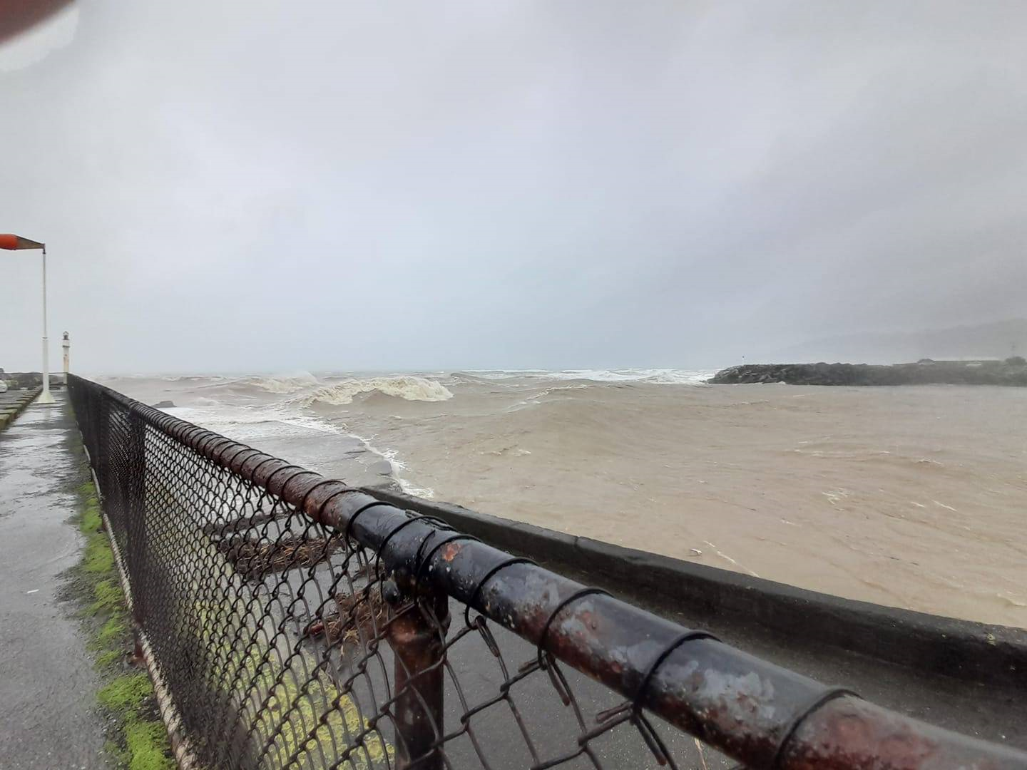
Westport and Nelson have been left isolated as high river levels, flooding, fallen trees and slips close state highways across the top of the South Island, RNZ reports.
The rare "red warning" urging West Coast residents to brace for wild weather has been extended for an additional seven hours as the region deals with flooding, slips, mass evacuations and major road closures.
The wild weather is also causing disruptions in the North Island - cancelling ferry services in Auckland and disrupting 28 domestic flights and blowing roofs off homes in Wellington.
Wellington City Council had by midday received "more than 20 calls to reports of flooding on roads and into private properties since 8am today – and the rain is continuing to fall heavily".
Crews are working to clear away a toppled tree in Oban St, Wadestown, while there have been multiple reports of flooding all over the city – including into shops in Adelaide Rd, Berhampore, the council says.
The MetService-issued red warning - only the third to be declared - for Buller and Westland is now due to end in Buller on Sunday at 3am.
More than 820 people were evacuated from 374 houses in Buller last night. Some residents in the Tasman District have also been forced from their homes.
The weather bomb that hit the South Island's West Coast this weekend - described as a one-in-50-year storm - has closed all roads into the Buller and prompted regional emergency management to declare a state of emergency.
Wild weather is expected to move up the country today - bringing periods of heavy rain to most of the North Island.
The country's weather authority has issued a spate of weather warnings for the country - including a North Island-wide strong wind warning.
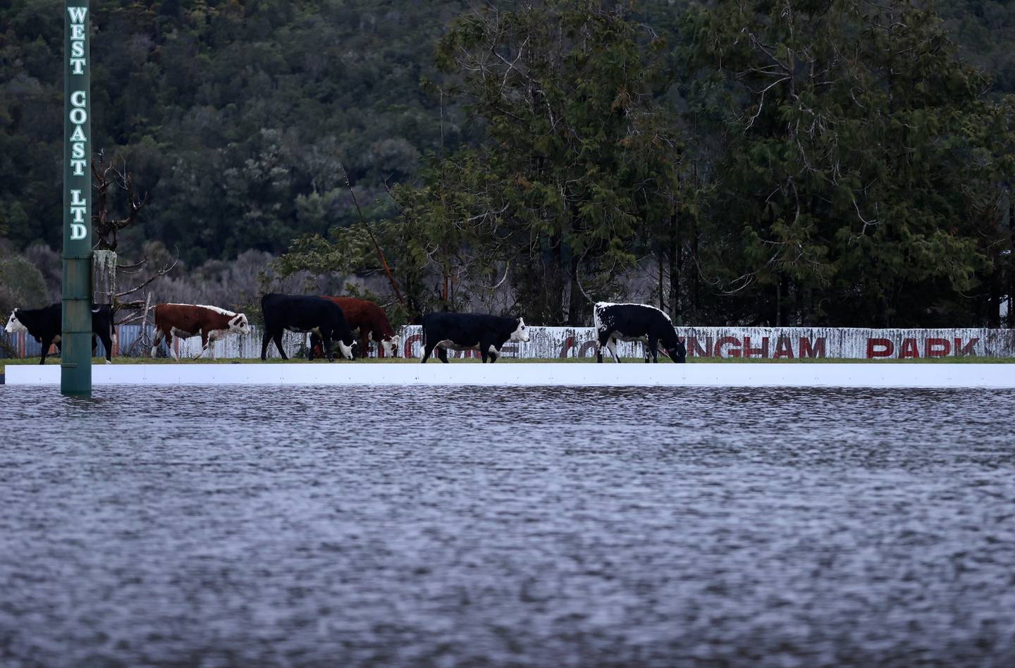
A flooded Wingham Rugby Park in Coal Creek, north of Greymouth. Photo / George Heard
"[It's] at least a 50-year flood event," he said.
There were nerves around the 3.30am high tide with a tidal surge predicted - but both had passed without significant impact, Cleine said.
Emergency response personnel were waiting until daylight to get a better idea of the situation - including when the currently closed roads into the region could be reopened.
State Highway 6 from Westport to Rapahoe and SH73 from Arthurs Pass to Jackons were both closed due to slips.
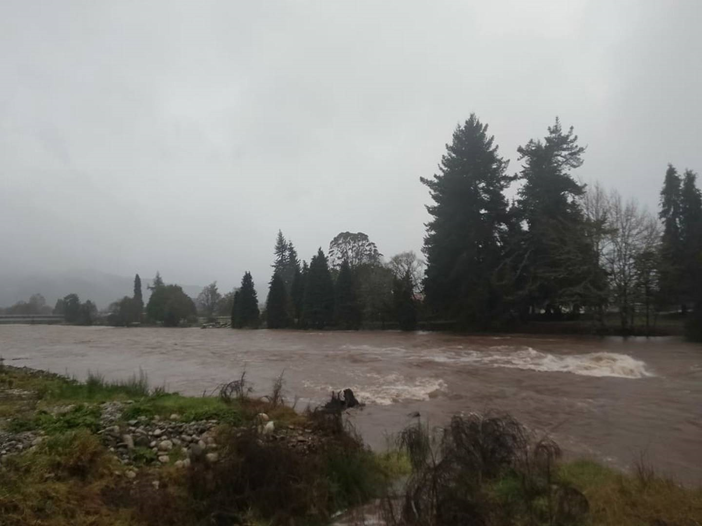
The raging Inangahua River in the Buller District. Photo / Supplied
SH7 from Ikamatua to Stillwater is closed due to flooding, while flooding and multiple slips have closed SH65 from O'Sullivans Bridge to Shenandoah, and SH60 from Collingwood to Riwaka.
In Wellington, Fire and Emergency had 28 weather-related calls overnight and responded to 19.
Shift manager Belinda Beets said many of them involved roofs being blown off.
A large section of a roof came off a house in Newtown. Roofing iron and a sign also came loose elsewhere in that suburb.
Steel was hanging from a roof on an apartment block on Taranaki St in the CBD, and doors were blown out in Ngaio.
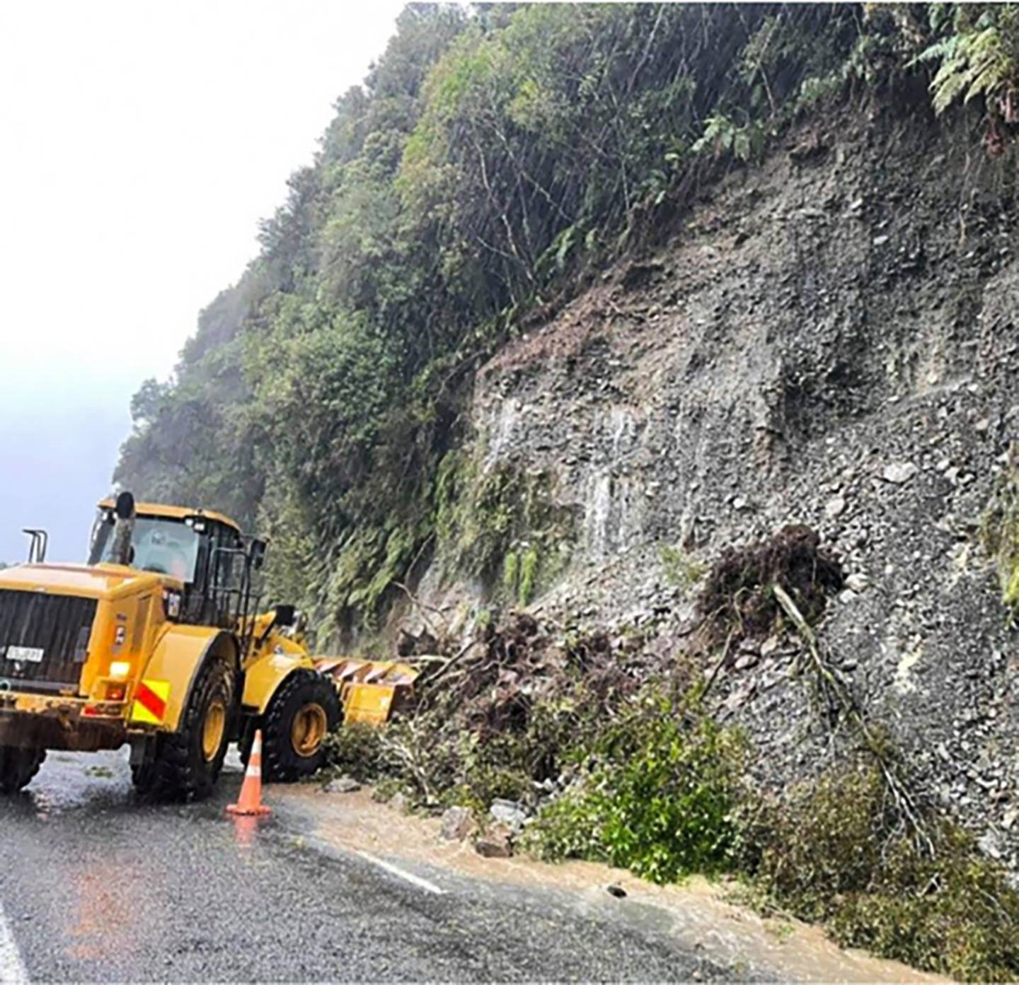
Workers try to clear a slip on State Highway 73 at Rocky Creek between Otira and Jacksons. Photo / NZTA
More than 700 people in Buller were evacuated from low-lying areas to four evacuation centres in the district.
Evacuated residents were this morning asked to "stay away" from their homes, as the risk of moving floodwaters remained.
West Coast Emergency Management this morning said there was still a large amount of water in the ranges that needed to make its way down the Buller River.
"We know you are keen to get home. We ask people to stay away from their homes while the risk remains. We will let you know when it is safe to return home."
Last night the Army deployed 14 personnel and seven vehicles from Burnham Military Camp in Canterbury to assist with evacuations following flooding.
When Cleine visited the centres this morning, people were sitting around playing cards - waiting for more information on the situation.
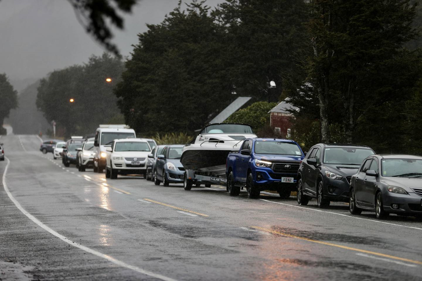
Traffic backs up on State Highway 73 as slips caused by heavy rain closes the road. Photo / George Heard
"We're just reinforcing that message that even though we're really happy with how things are going, we just need another couple of hours to make sure the river has settled down."
In Westport, Fire and Emergency received 12 calls about trees that had blown down.
Shift manager Lyn Crosson said fire crews didn't attend some of those because the council attended instead.
Wild weather on the Blaketown Tiphead, Greymouth. Photo / St John
Weather warnings across the country
MetService has issued a strong wind watch from the Far North to the capital city - in effect until 8pm tonight.
North Islanders were being warned wind strengths could approach severe gale in exposed places.
Up to 200mm of rain could accumulate about Mt Taranaki and up to 120mm about the Tongariro National Park.
Taihape and inland Whanganui are in for a windy Saturday with north to northwest winds expected to be severe in exposed places, with gusts of up to 120km/h.
It is a similar story on the other side of the North Island, with a heavy rain warning in place from 1pm to 10pm on the Bay of Plenty, east of Whakatāne and the ranges of Gisborne.
Heavy rain warnings are also in place for the Tararua Ranges until 6pm in Wellington - and until 3pm in Marlborough.
Take your Radio, Podcasts and Music with you