Meteorologists are warning that a tropical cyclone forming in the Coral Sea and on track to hit New Zealand could cause major impacts for the North Island and unleash a month’s worth of rain in just days.
NIWA meteorologist Ben Noll said the storm would be more than an average low pressure system and would be “quite impactful”.
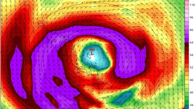
“It’s going to come pretty close to New Zealand, now in terms of the exact track, say just to the west of the North Island or just to the east of the North Island.
“That’s the kind of detail that is going to be refined in the coming days and that detail will actually mean a lot as to which regions see the most hazardous weather,” said Noll.
“I would describe it as above average confidence that the system will move into the New Zealand region.”
International weather modellers expect the storm to reach our shores from Sunday.
Noll said the country, especially flood-ravaged regions such as Auckland, Northland and the Coromandel, could be dealing with a large amount of rain given the system has emerged in the tropics.
“When you’re talking about a system that was once in the tropics you could be talking about a month’s worth of rain or more. That does depend on the forward speed, how fast the system is moving and what part of the country it moves into,” he said.
Noll said there is potential for powerful winds strong enough to do damage.
He also said the storm would cause rough seas despite whether it would track over the country or not.
MetService meteorologist Peter Little said the cyclone would “absolutely” head towards New Zealand but also said it was too early to say if it would track over the country or if it would be further away.
Various weather models currently show that the cyclone’s centre will track over the top of the North Island.
“The system is expected to track south eastwards, there are some differences in how quickly it is brought south eastwards and whether it will be near the country or whether it will be a little bit further away but certainly there is a risk of further heavy rain for northern parts of the country from very late on Sunday into Tuesday,” said Little.
“We’re monitoring very closely obviously because even a small amount of rain for some of the areas recently hit by flooding could cause problems.”
Little said even a small change in the cyclone’s position or intensity over the next few days would have a large impact on where the system would end up.
“A very small change in the next couple of days could end up with a different picture,” he said.
Meanwhile, Hauraki Gulf Weather tweeted that the storm could be historical if it were to form and said it would bring dangerous winds with it.
“All main global models apart from the Chinese brings a strong extra-tropical cyclone into the upper North Island late Monday. With over five days out, things can still change, so this is still early guidance but the trend remains concerning,” said the forecaster.
WeatherWatch said the developing weather trend over the past few days has been concerning. It said more certainty of the cyclone’s path would be known on Friday.
Take your Radio, Podcasts and Music with you