Brace yourselves for the big chill – weather experts are forecasting the "first proper winter blast of 2022" to hit the country this coming weekend.
MetService says a northwesterly flow will bring significant amounts of rain across many areas before turning westerly, with snowfalls expected by Friday.
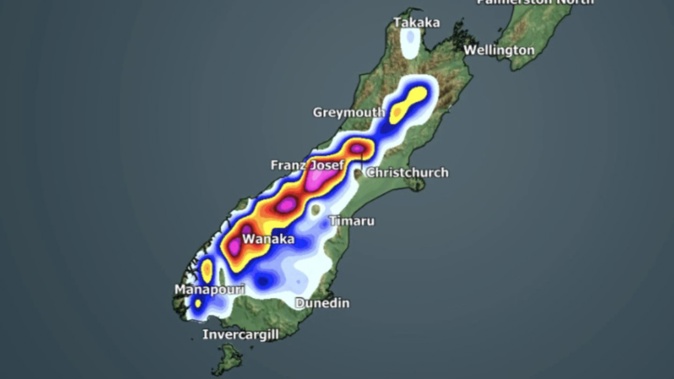
"Conditions are likely to cool significantly over the South Island with snow expected in many mountain areas, especially on Friday," it noted.
"Note that this is likely to be the first heavy snow of the season in these areas and snow may lower to levels where it can cause stress to livestock."
WeatherWatch says there is a chance for snow down to sea level in Southland and Otago, and low levels in some parts of Canterbury.
This means potential snowfall on Saturday in Dunedin, Invercargill, Gore and Queenstown.
It is describing the weather to be the first proper winter blast of 2022.

MetService is forecasting heavy snow in some areas on Friday. Image / Supplied
But WeatherWatch head forecaster Philip Duncan said a lot could change between now and the weekend, and that the forecast was based in part on a Southern Ocean storm that is looking possible this week.
This could bring in an Antarctic southerly by Friday or Saturday.
"In recent days Tasmania, Victoria and NSW have all had snow events on the mountains and ranges with snow levels as low as 300m," he said.
Duncan said it's too early to lock this in but there should be a clearer picture of what's in store by Tuesday.
WeatherWatch.co.nz said the best chance for Antarctic blasts in New Zealand is "when a powerful high lies over Tasmania shaped north-to-south, while a deep low lies south to southeast of Dunedin.
"The two then work together to dredge up Antarctic southerlies."
MetService meteorologist Dan Corrigan said it is still too far out to make decisive statements about snowfall forecasts.
But the service says it is moderately confident of rainfall accumulations reaching warning amounts for Westland and Buller on Wednesday, extending to the Tararua Ranges by Thursday and Friday.
"There is a moderate confidence of snow accumulations reaching warning amounts above about 800 metres for the Canterbury high country south of the Rangitata River and for Otago west of about Alexandra (on Friday)," MetService said.
"There is a moderate confidence of severe northwesterly gales about the Marlborough Sounds, Wellington and Wairarapa, including the Tararua District."
- by Lincoln Tan, NZ Herald
Take your Radio, Podcasts and Music with you