Heave a sigh of relief New Zealand; Cyclone Owen, which has been bashing the Northeast of Australia, is unlikely to impact our weather.
Metservice forecaster Cameron Coutts told the Herald the cyclone would track down Queensland and weaken, not impacting our shores.
However, just because the country isn't going to be hit by the cyclone doesn't mean we're in for good weather.
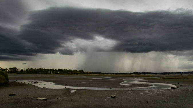
Coutts said much of New Zealand is in for similar weather which has planted itself over the country throughout this week.
"It's basically a repeat of today with most of the country under some risk of thunderstorms," he said.
"The main areas are in the central inland parts of the North Island, from Hamilton down to Masterton almost across to Gisborne and pretty close to the Taranaki.
"In the South Island, it's concentrated in the northern portion of the inland area around south of Nelson down to about Arthurs Pass."
A low-pressure system sitting to the west of the country along with a ridge to the southeast is creating the stationary weather features.
A mixture of day-time heating, wind conversions which are accompanied by colder air at higher levels is contributing to the thunderstorm weather.
More of the same is expected throughout the weekend as the low slowly fills and another ridge moves over the country from the southwest.
Coutts predicts Auckland will continue its trend of typical Auckland weather which can't make it's mind up.
"We're talking about some showers after lunch and there could be a thunderstorm amongst that and not a lot of wind," he said.
"Look at temperatures, sort of heading to the low 20s and on Saturday it's much of the same again, more showers off and on.
"Typical Auckland weather, lots of sunny spells but you could get wet."
Showers aren't expected to hamper the Capital on Saturday, meaning the Black Caps should be able to get underway against Sri Lanka in the first home test.
Wellington will be blanketed by cloud cover in the morning which will slowly degrade away to reveal blue sky as the day goes on.
Friday's forecast:
Whangarei:
A few showers, especially after midday, possibly heavy and thundery. Northerly breezes. High 24C, Low 15C.
Auckland: A few showers, especially after midday, possibly heavy and thundery. Northerly breezes. 24C, 16C.
Tauranga: Showers, more frequent for a time late morning, then becoming fine. Light winds. 23C, 16C.
Hamilton: Showers, some heavy and thundery during the afternoon and evening. Light winds. 24C, 13C.
Napier: Partly cloudy, and a few afternoon showers. Light winds. 22C, 14C.
New Plymouth: Cloudy periods, and an afternoon shower or two. Northerly breezes. 20C, 13C.
Wellington: Cloudy morning and evening, but afternoon fine spells and a shower or two. Southeasterly breezes. 21C, 14C.
Nelson: Cloudy with one or two showers. Becoming fine evening. Light winds. 21C, 14C.
Christchurch: Morning low cloud and drizzle then fine spells. Cloud returning at night. Easterly dying out. 20C, 11C.
Queenstown: Partly cloudy with chance afternoon and evening shower. Light winds. 23C, 11C.
Dunedin: Morning cloud then fine spells. Cloud returns at night. Northeasterly dying out. 20C, 13C.
Invercargill: Fine apart from morning and evening cloud. Light winds. 21C, 11C.
Take your Radio, Podcasts and Music with you