More rough weather is forecast to hit the lower North Island today, with a storm coming from the Tasman Sea.
A number of heavy rain and strong wind warnings have been issued for the bottom of the North Island and top of the South Island.
The latest MetService bulletin includes a heavy rain warning for Hawke's Bay, a region already dealing with storm damage this month after it was hit by a one-in-250-years flood.
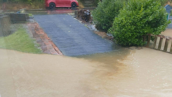
Yesterday, residents of a small Porirua community were evacuated from their homes as flash flooding sent rivers of water running through residential streets.
Close to 15 households were left uninhabitable and locals had to clean up the mud-caked streets after a perfect storm hit the Karehana Bay area in Plimmerton.
The flooding also brought traffic in and out of the region to a standstill on State Highway 1, as water filled up the Plimmerton roundabout area and caused the main route north of Wellington to be closed.
MetService forecaster Aiden Pyselman yesterday warned the deluge was not over. There was another front coming through, bringing more rain.
"Tomorrow there is a storm coming in from the Tasman Sea," he said.
A heavy rain warning was now in place for the Wellington region and Tararua Range, and winds were forecast to reach gusts up to 120km/h.
The warning comes into force this evening, with the capital expected to see local heavy falls that are expected to be so intense there will be a threat of flash flooding and slips.
MetService is warning violent wind gusts could damage trees, powerlines and unsecured structures. It says driving may be hazardous, especially for high-sided vehicles and motorcycles.
Strong wind watches are also in place for Taranaki and Bay of Plenty with southerly winds expected to ramp up to gale force overnight into tomorrow.
MetService said the Wairoa district could expect up to 90mm of rain across tomorrow from 8am with intense downpours. It warned the heavy rain could lead to flash flooding and slips.
A welfare point for displaced residents has been set up at the Plimmerton fire station.
Pyselman said Porirua recorded 49mm of rain between 2am and 11am, while nearby areas recorded between 65mm and 74mm.
Porirua received more than 38mm of that rain from 7am to 11am.
"It's been quite frightening actually because it came up so fast," one woman said yesterday afternoon, still shaken by how quickly the flooding hit.
"It's absolutely terrible."
She was one of the "lucky ones", with water only reaching the doorway.
Further along the road, people found dirty, brown water pouring into their homes as it ran like a river down the street outside, popping out manhole covers and streaming through the undercarriages of parked cars.
Another resident said she lived on a hill, but had been to visit a friend whose entire house was flooded with up to 40cm of water.
Porirua Mayor Anita Baker said she'd "never seen so much water" in the area around Karehana Park.
"That has risen before because it's got a little stream, but never like that. I've never seen it in my time that bad."
Take your Radio, Podcasts and Music with you