Brace yourselves, New Zealand - strong winds and freezing air are set to swoop over the country today, causing ongoing disruption to travel with snow down to sea level in some spots.
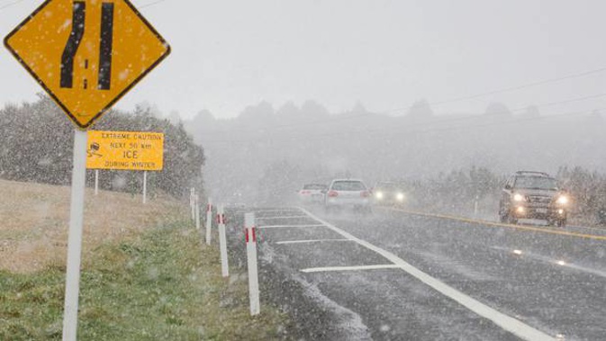
Road closures are expected across the South Island and in the central North Island as the snow sets in, with the first snow showers arriving in Invercargill at about 6am.
It's all part of a Southern Ocean storm that's smashed into New Zealand, bringing dangerous waves, gales and bitter cold.
The cold air is coming straight off the Antarctic Shelf, according to Niwa.
Timaru was the coldest spot in the country early this morning at -0.5C.
As of 7.30am there were no closures in the central North Island but a front moving up the North Island was forecast to bring snow between 9am and midday, and again later in the afternoon.
The NZ Transport Agency warned drivers to expect snow and ice on the Desert Road and surrounding areas, and to drive with care around the Tongariro National Park.
The western coastlines of both islands can expect rain and showers today, including some squally falls with hail, according to the MetService.
Strong winds are also possible in Hawkes Bay and Wairarapa until 11am.
The MetService warned last night that the South Island could see significant disruption to travel today, with snow expected down to sea level around Southland, Clutha and southern Fiordland where a heavy snow warning is in place. Heavy snow watches are also in place in many other parts of the South Island.
Heavy snow may disrupt travel in affected areas and could damage trees and powerlines, the MetService said. Cold could also cause stress for livestock.
The surge of southerlies and southwesterlies wouldn't ease nationwide until Monday evening, Weatherwatch.co.nz said.
Today's weather
Early showers, then rain late morning to early afternoon. Frequent showers from evening. Northwesterlies, changing southwest late afternoon. High 16C, Low 7C
Auckland Early showers, then rain late morning to early afternoon. Frequent showers from evening. Strong northwest, changing strong southwest late afternoon. High 14C, Low 7C
Hamilton Showers turning to rain in the morning, clearing midday. Showers returning evening. Northwest winds, changing southwest by afternoon. High 13C, Low 4C
Tauranga Chance morning shower, then rain midday to early afternoon. One or two showers returning evening. Westerlies. High 14C, Low 5C
New Plymouth Rain, possibly heavy and thundery, clearing late morning as strong westerlies ease. Showers from late afternoon with westerlies strengthening. High 14C, Low 5C
Napier Cloudy periods. Scattered rain late morning through early afternoon. Chance evening shower. Northwesterlies, gusty morning and evening. High 16C, Low 3C
Whanganui Rain, clearing by midday as strong westerlies ease. Frequent showers from early evening as westerlies restrengthen again. High 14C, Low 5C
Wellington Scattered rain, clearing late morning. Showers from early evening. Strong northwesterlies turning southwesterly at times. High 13C, Low 4C
Nelson Fine spells. Rain again in the afternoon. Gusty southwest turns northerly for a time. High 11C, Low 0C
Christchurch Fine spells. Chance evening shower. Southwesterlies, dying out for a time. High 9C, Low -2C
Dunedin Fine spells. Showers return evening with snow to 300 metres. Southwesterlies, strong about the coast at times. High 7C, Low 2C
Take your Radio, Podcasts and Music with you