Heavy rain and thunderstorms are likely for most of the North Island today, with snow warnings also in place for Canterbury and Otago.
Severe thunderstorms were predicted in the early hours of this morning, about western parts of the North Island north of Wellington and about western Nelson, Buller and northern Westland.
These thunderstorms could bring localised downpours of 25 to 35mm per hour, large hail or large accumulations of hail, damaging winds gusting greater than 110km/h.
There is also the possibility of small localised tornadoes, mainly near the coast.
Severe Thunderstorm Watch issued https://t.co/iOKsMBgUIr pic.twitter.com/SaA7Ihmlwn
— Severe Weather Info (@MetServiceWARN) August 10, 2019
Severe weather warnings are in place with heavy rain forecast about the Tararua Ranges until 1pm tonight, and around the Canterbury Plains and foothills and south of the Rangitata river and North Otago until later this morning.
Other areas to watch for heavy rain are Waikato, Waitomo, Taumarunui, Taranaki, the ranges Bay Of Plenty east of Whakatane, Nelson west of Motueka and Buller, and Dunedin.
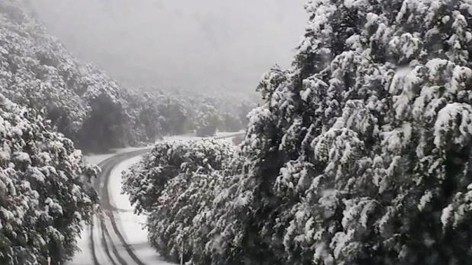
Heavy snow warnings are in place for Canterbury and south of the Rangitata River, North Otago and Dunedin.
Snow is forecast down to 300m with significant falls above 500m.
Road snowfall warnings are also in place for Lewis Pass (SH7), Arthur's Pass (SH73), Porters Pass (SH73), Haast Pass (SH6), Lindis Pass (SH8), Crown Range Road, Milford Road (SH94) and Dunedin to Waitati Highway (SH1).
Road Snowfall Warning issued for Lewis Pass, Arthur's Pass, Porters Pass, Haast Pass, Lindis Pass, Crown Range Rd, Milford Rd, Dunedin to Waitati Highway https://t.co/wH7mYlYSF6
— Severe Weather Info (@MetServiceWARN) August 10, 2019
Metservice meteorologists Melissa Oosterwijk said lightning was recorded in quite a few places overnight, with strikes still being recorded early this morning about the Gisborne Hills and the Tararua Ranges.
"It has been quite an active night for thunderstorms and rain for large parts of the country overnight. A lot of it has eased over the last couple of hours but we are expecting more convection and thunderstorms again today," she said.
"Today we have moderate risk of thunderstorms for a large proportion of the North Island, and a lot of the South Island is expected to get rain but it will probably be heavier on the West Coast.
"However, the snow risk to lower levels is easing this morning, but the rest of the rain and thunderstorms will be quite similar to yesterday."
The bleak weather is looking to carry on into this week, with a trough moving northeastwards across central and northern New Zealand tomorrow, delivering a period of northwesterly rain with heavy falls to many places, followed by a strong and unsettled southwest flow.
This could bring warning amounts of rain for the central North Island and the West Coast, along with gale force north to northwest winds in exposed parts of central and northern New Zealand.
On Tuesday, a strong and unsettled southwest flow will spread across the country, which should remain through Wednesday and then gradually ease on Thursday.
Today's forecast
Showers, especially from afternoon. Some possibly heavy and thundery. Northwesterlies strengthening afternoon. High 19C / Low 11C.
Auckland: Showers, some heavy with possible thunderstorms and hail. Strengthening northwesterlies. High 17C / Low 11C.
Tauranga: A few showers, some heavy and possibly thundery, more frequent from afternoon. Northwesterlies, strengthening afternoon. High 17C / Low 10C.
Hamilton: Showers, some heavy with possible thunderstorms and hail. Gusty northwesterlies. High 16C / Low 9C.
New Plymouth: Showers, some heavy and squally with possible thunderstorms and hail. Strong northwesterlies. High 15C / Low 9C.
Napier: Cloudy periods. A few showers from late afternoon. Gusty northwesterlies. High 19C / Low 8C.
Wellington: Occasional showers, with possible thunderstorms this morning, turning to rain by evening. Strong northerlies, dying out evening. High 14C / Low 7C.
Nelson: Occasional rain, especially from afternoon. Northerly breezes. High 13C / Low 5C.
Christchurch: Cloudy with light rain at times. Southwesterlies. High 12C / Low 3C.
Dunedin: Rain, possibly heavy, with snow to 300 metres at first, gradually easing. Easterlies. High 8C / Low 4C.
Take your Radio, Podcasts and Music with you