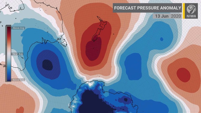
One of the strongest high-pressure systems on the planet is about to move over to New Zealand, bringing freezing temperatures that could plunge as low as -15C in some parts of the south this weekend.
The pattern is expected to coincide with another period of dry weather for Auckland – hardly welcome news for local drought-hit farmers needing rain to battle back from a 240mm deficit.
Niwa meteorologist Ben Noll said the approaching high also came nearly a year after a similarly dramatic system drifted over the country, which pushed air pressure to 1043.2 Hectopascals (hPa).
"Here we are about a year into the future, and we are talking about another tremendous area of high pressure - and what looks to be quite possibly the strongest area of high pressure on the globe - centering itself over New Zealand as we go into Saturday and Sunday," Noll said.
"For the upcoming weekend, it looks to possibly centre over the top of the South Island where the highest pressures will likely be."
Atmospheric pressure is the force of air pulled towards the earth by gravity. The highest pressure recorded in New Zealand was in Wellington in 1889 at 1046 hPa.
Noll said the highest values ever recorded for this month was the 1044.7 hPa measured over the South Island on June 5, 2016.
"The modelling we have for the feature coming this weekend shows it could be in the low 1040s, which puts us in the ballpark of where we could be talking about near record, or even record values, for surface pressure in the atmosphere."
For the South Island, Noll said weekend temperatures could get "very, very cold".
"We are talking about temperatures as cold as -15C in some low-lying areas about the alps on Saturday morning, creating some pretty frosty conditions," he said.
"These are some pretty extreme cold anomalies, so no doubt people will have to watch out for things like black ice."
It would follow a weekend that saw the chilliest nights of the year for some places in the south.
Christchurch saw its coldest and second coldest nights of the year so far on Sunday and Monday mornings respectively, while Timaru got down to -5.3C in the early hours of Saturday, MetService reported.
Pukaki also saw its coldest night, with -6.4C early Sunday.
This morning, it was the north's turn to feel the chill, with Masterton, Galatea and Wellington (at Kelburn) recording lows of -1.5C, -2.5C and 5.3C respectively.
The coldest temperatures recorded over recent years were -9.2C last year (Lake Tekapo, June 3), -10.4C in 2018 (Mt Cook Airport, June 3) and -14.6C in 2017 (Tekapo, July 29).
For Auckland, Niwa was forecasting mostly dry and settled conditions over the next seven to 10 days.
"We are looking at a period of dry conditions, especially for this time of year, when we'd normally expect to see rain every other day," Noll said.
"And when you have a dry spell of five to seven days in June, it will be noticed by people."
Forecasts for the weekend still pointed to the possibility of rain for Auckland: Niwa was projecting around 4mm on Saturday, while MetService was also forecasting rain, with easterlies developing.
"When you get slow-moving features like this, on the periphery can be fronts that stall out, and actually bring rain to some places, despite the pressure being really high," Noll explained.
"I guess there is a chance for that in the upper North Island as we go from Saturday into Sunday."
Overall, however, farmers and growers in the region were still dealing with a rainfall deficit of around 240mm, he said.
"I've heard from farmers that they're doing a bit better following a rain event at the tail end of May, which is good news – but it's important for people to remember that stream flows and dam levels are still pretty low, and conditions for this week coming up are not going to bode well for that."
This morning, Watercare reported Auckland's dam levels were sitting at about 45 per cent capacity, compared with a normal average of 77 per cent for this time of year.
But water consumption levels were encouraging: over the past seven days, Aucklanders used an average 404 million litres each day, which was below the target of 410 million litres.
Watercare has received more than 700 reports of misuse since tough restrictions began on May 16, but hasn't had to issue any fines as there have been no repeat offenders.
Take your Radio, Podcasts and Music with you