All Air New Zealand flights in and out of the country's southernmost airports - including Queenstown - have been cancelled due to the worsening weather.
The national carrier today said the polar blast was causing disruption across much of the South Island with Dunedin, Invercargill and Queenstown flights now cancelled due to the wind and snow.
Twenty-six flights had so far been cancelled over the coming two days.
A spokesperson said with the challenging conditions expected to last through to tomorrow the airline was now working through recovery flights for stranded passengers.
Further travel disruption is expected with the Interislander ferry cancelling all sailings tomorrow and likely to be extended into Wednesday.
A heavy snow watch is now in force for much of the country, stretching from the deep south to the centre of the North Island.
Snow is falling and temperatures are starting to dive as the polar blast touches down bringing snow to sea level in parts of the south, huge seas and gales laced with a bitterly cold -20C windchill.
An enormous cold air mass straight off the Antarctic ice shelf is now hitting parts of the South Island with snow expected down to 100m in southernmost regions.
MetService has now updated its forecast with heavy snow forecast across main centres of the South Island and across the Cook Strait, from Wellington up to the Volcanic Plateau.
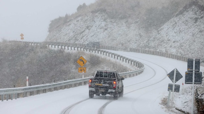
An Otago highway is now closed by heavy snow with motorists being told to find another route.
Forecasters say the cold front will sweep northwards up the country during Monday, opening the freezer door to all of New Zealand.
The latest snow alert, which encompasses two-thirds of the country, will see snow start falling in the North Island tomorrow morning.
A road snowfall warning is now in place for the Napier-Taupo Rd, Desert Rd and Remutaka Hill Rd in the north along with a number of alpine passes in the south.
MetService says snow is expected to lower to 300m in the eastern hills of the capital city from around 10am.
Many of these regions will be hit by fierce winds with MetService issuing strong wind watches for eastern and central regions across New Zealand.
Niwa Weather says there is even the likelihood those in the south will see temperatures plummet to an icy -20C thanks to a "brutal" wind chill adding an icy sting during this week's polar blast.
Wild winds are already posing problems for central New Zealand with trees blown down across a road closing a section of State Highway 50 in Hawke's Bay.
Interislander executive general manager Walter Rushbrook said the situation was being reviewed constantly.
"We are about to get some very rough weather through the strait, and we will not resume sailing until we are confident we can do so safely," he said.
The Kaiarahi 10.30pm sailing from Picton tonight would be the last sailing before the cancellations come into effect.
MetService is warning the severe gales bringing bitterly cold conditions across much of the South Island will cause stress to livestock, and thick settling snow expected to make driving hazardous.
Cold sleety rain is starting to fall in southern regions with heavy snow forecast to fall in Southland and Central Otago.
At 9.15am State Highway 87 between Outram and Kyeburn in Otago was closed by snow and motorists told to find an alternative route north.
Snow and ice on the Crown Range in Queenstown has forced drivers to carry chains and drivers across the Wakatipu Basin and in Wanaka are being urged to watch for rockfall.
This morning Treble Cone was coated in 15cm of snow on the upper slopes and Cardrona has received around 10cm so far. Both mountains were expecting more snow this afternoon.
MetService has issued a swathe of storm warnings affecting most of the South Island, and eastern regions of the North Island.
Road snowfall warnings are now in effect on all alpine passes with up to 8cm of snow expected to fall on worst affected areas.
A warning comes into effect for the Dunedin to Waitati highway in Otago after lunch.
A heavy swell alert has also been issued for Wellington's coastline with 6m swells expected to batter the southern coast from Tuesday morning through to Thursday.
People who live in the affected area are being warned the worst is when the swells coincide with high tide.
MetService has also issued a warning about the severe gales expected to bring bitterly cold conditions across much of the South Island causing stress to livestock, and with snow forecast to affect many South Island roads and passes driving expected to be hazardous.
There are also a number of strong wind warnings being issued across the North Island including the Desert Rd, Hawke's Bay and Manawatū for those driving high-sided vehicles or motorcycles to take extra care.
MetService is warning heavy swells will cause problems around many coasts over the next few days.
Niwa principal scientist Chris Brandolino told The AM Show it would be a "big punch of cold air" from the heart of the ice continent with the South Island bearing the brunt of the storm.
He described the wind chill factor as "brutal" with the temperatures starting to dive into negative territory from after lunch.
Even the capital city would experience negative wind chill of -5C tomorrow on the back of strong gales.
The coldest weather would be experienced tomorrow in the south but even on Wednesday frosts would hit Auckland.
Take your Radio, Podcasts and Music with you