Kiwi holidaymakers could be looking forward to an unusually hot and sticky January as the country is enveloped by resurgent marine heatwave conditions.
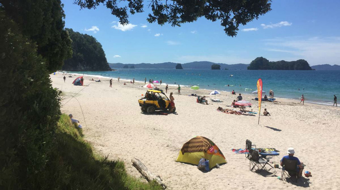
The balmy ocean temperatures, already up to 3C above average in some regions, will be welcome news for thousands of people fleeing the office and flocking to the beach.
But the elevated conditions may also worsen humidity in many places this summer, adding to uncomfortably hot days and nights.
Authorities are also warning of higher fire danger in many parts of the country, after months of rain and vegetation growth.
/cloudfront-ap-southeast-2.images.arcpublishing.com/nzme/BX4TCXIJT5AA3A6SUDOZSFRF2Y.JPG) The balmy ocean temperatures, already up to 3C above average in some regions, will be welcome news for thousands of people fleeing the office and flocking to the beach. (Photo / George Novak)
The balmy ocean temperatures, already up to 3C above average in some regions, will be welcome news for thousands of people fleeing the office and flocking to the beach. (Photo / George Novak)
Water safety experts are also urging beachgoers to take extra care around the ocean, lakes and rivers, with the summer holidays representing the peak danger period for drownings.
Niwa forecaster Ben Noll said sea surface temperatures (SSTs) jumped in the past two weeks with coastal waters now running between 1C and 3C above average ahead of the busy holiday period.
“We’re looking at a moderate marine heatwave signal at present, with the opportunity to become something more severe in coming weeks.”
For beachgoers, a marine heatwave - defined by SSTs being at the upper bounds of historical observations for at least five days - meant noticeably balmier water.
But ocean heatwaves have also fuelled scorching days and nights, wildfires, glacier melt and a host of damaging effects for ocean life.
After seas warmed up over a record-hot November, they cooled around the start of this month, bringing a brief respite after two years of relentless marine heatwave conditions in many regions.
Now, Noll said, sea temperatures were soaring once more.
“It’s really warmed up over the past 10 to 14 days with the arrival of warmer air masses,” he said.
“We’re seeing anomalies in the order of 1-3C above average, pretty much right across the country, but the real hotspots are the west coast of the upper South Island, near places like Westport and Greymouth, where SSTs are tracking at 2-3C above average.”
Similar values were being observed around Tasman and Golden Bay, and further up the country near Manawatu and Taranaki.
“But because everywhere is basically elevated by about a degree, if you’re swimming at the beach, you’ll definitely notice that it’s pretty warm.”
/cloudfront-ap-southeast-2.images.arcpublishing.com/nzme/L3NG6IIHLZCUDMOSZOO6RNZL6A.jpg)
While our seas weren’t yet as unusually warm as they were this time last year, Noll said this year’s heatwave looked to be just getting going.
“As we look ahead, there are going to be some really hot temperatures between Boxing Day and New Year, especially in the west of both islands,” Noll said.
“We can expect to get to a place where the feedback mechanism between coastal SSTs and land temperatures really start to work off of one another, which means warmth can get locked in for extended periods.
“It may even be the case that this warm weather we’re about to get locks us in for a hot, sticky January.”
Niwa’s summer climate outlook predicted above-average temperatures throughout most of the country, with more subtropical northeast winds likely to bring more scorching days for inland and western areas.
For eastern spots, however, fewer northwesterly foehn winds spells fewer hot days – a regional contrast typical of La Niña’s traditional influence over summer.
While SSTs typically peaked mid-summer, past years had shown warmer waters could linger through autumn and beyond.
Just how long this heatwave lasted would dictate what extreme impacts it came with: notably melting ice, tropical fish drifting into colder climates and kelp dying.
Scientists would also be watching for damaging knock-on effects for species deeper in the ocean, like crayfish and sponges, that couldn’t so easily escape the heat.
Marine heatwave conditions recently recorded in Fiordland – where sea surface temperatures have soared to 5C above normal – have proven the most impactful seen.
Scientists were alarmed this year to discover millions of sea sponges there had turned from velvet-brown to bone-white – one of the worst bleaching events documented among sponge species anywhere.
Warmer coastal waters could energise low-pressure systems – meaning heavier deluges - but also contribute to heatwaves and fire danger on land.
With La Nina steering our summer climate once again, Fire and Emergency NZ (Fenz) has predicted fire danger would be higher this season in the north and west of the North Island and the south and west of the South Island, but lower in eastern areas.
“We’ve had warmer than normal conditions, with good rainfall across many areas,” Fenz national wildfire manager Tim Mitchell said.
“It’s great that it’s green but if people don’t stay on top of that growth - and it dries out - it could become a significant fire risk.
“This is particularly dangerous around buildings and homes, as dry grass can help fires spread very quickly.”
But while New Zealand had recently seen a string of record or near record summers, with plenty of moisture in the ground ahead of our warmest weeks of the season, the country wasn’t starting off as dry as last year.
Soil moisture was currently at low levels only in central and coastal Otago, Banks Peninsula and pockets elsewhere in eastern regions.
“The first week of December was cooler than usual, but La Niña temperatures are kicking in, producing above average summer temperatures, overall,” MetService forecaster Georgina Griffiths said this week.
As our planet heats, scientists only predict marine heatwaves to grow longer, stronger and more severe.
Niwa researchers recently warned local average sea temperatures could rise by 1.4C within four decades – and almost 3C by the century’s end.
That would mean that, by mid-century, we could be facing 260 days of marine heatwaves per year – and 350 days by 2100 – compared with the 40-odd days we see now.
Take your Radio, Podcasts and Music with you